US Highway 16 Corridor Study – Public Meeting #3
Welcome
US Highway 16 Corridor Study
Virtual Public Information Meeting and Open House
Welcome to our US16 Corridor Study virtual engagement! The South Dakota Department of Transportation (SDDOT) in conjunction with the Rapid City Area Metropolitan Planning Organization (RCAMPO), City of Rapid City, Pennington County, and the Federal Highway Administration (FHWA) are leading a study to develop a long range-plan for the US16 corridor. Thank you for your participation in our online engagement.
The range of transportation improvement scenarios throughout US16 presented here are ready for public and stakeholder feedback. These scenarios group refined concepts presented at the previous public meeting and represent potential future projects to address long-term transportation needs.
Consultant recommendations of the technically feasible option have also been developed for the US16/Neck Yoke Road intersections and US16/US16B/Catron Boulevard intersections, for your review and feedback. We appreciate your input.
How to Navigate
- Click the arrows on the right of your screen to go forward or the left to go backward. Use the navigation bar on the left side of your screen to revisit any part of the meeting.
Presentation Overview Video
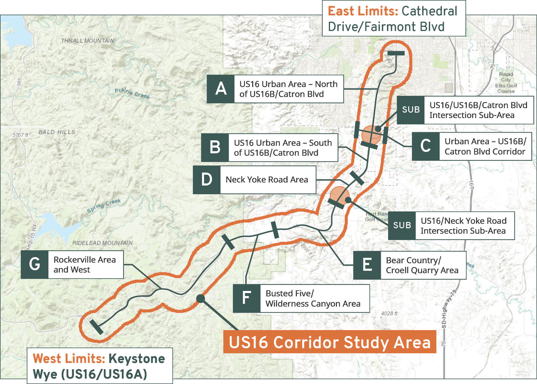
Project Area Map
Click on a segment label to learn more about the scenarios and analysis for each.
 Label 1 Text
Label 2 Text
Label 3 Text
Label 4 Text
Label 5 Text
Label 6 Text
Label 7 Text
Label 8 Text
Label 9 Text
Label 1 Text
Label 2 Text
Label 3 Text
Label 4 Text
Label 5 Text
Label 6 Text
Label 7 Text
Label 8 Text
Label 9 Text
US16/US16B/Catron Boulevard Intersection
Project Sub-Area
Segment Overview
Purpose and Need
The project team shared the preliminary purpose and need statements at the previous public meetings and solicited your input. Preliminary build options for each intersection have been developed to satisfy the identified project needs.
Purpose:
To improve traffic operations and safety at the US16/US16B/Catron Boulevard intersection, and with the goal of supporting the planned mix use urban development that is occurring in the area.
Needs:
Poor traffic operations. The existing intersection is functioning at a level of service (LOS) D for AM and LOS E for PM peak hour traffic. Future 2045 traffic operations are expected to worsen to LOS F. LOS C or above is considered acceptable congestion and traffic operation.
High crash rates. High speed and increased traffic volumes contribute to high crash rates. The high speed contributes to fixed object crashes, merge area crashes, and disregard signal crashes. Of the 88 total crashes, 48 were angle and 32 were rear end.
Rapidly urbanizing land use. The area around the intersection is currently undergoing a transition from rural to urban uses. The Rapid City Comprehensive Plan identifies the area around the intersection as a community activity center. As urbanization continues, the number of vehicle trips to and from the new urban uses will continue to increase.
Intersection Build Options – Download PDF – SPI animation – DLT animation
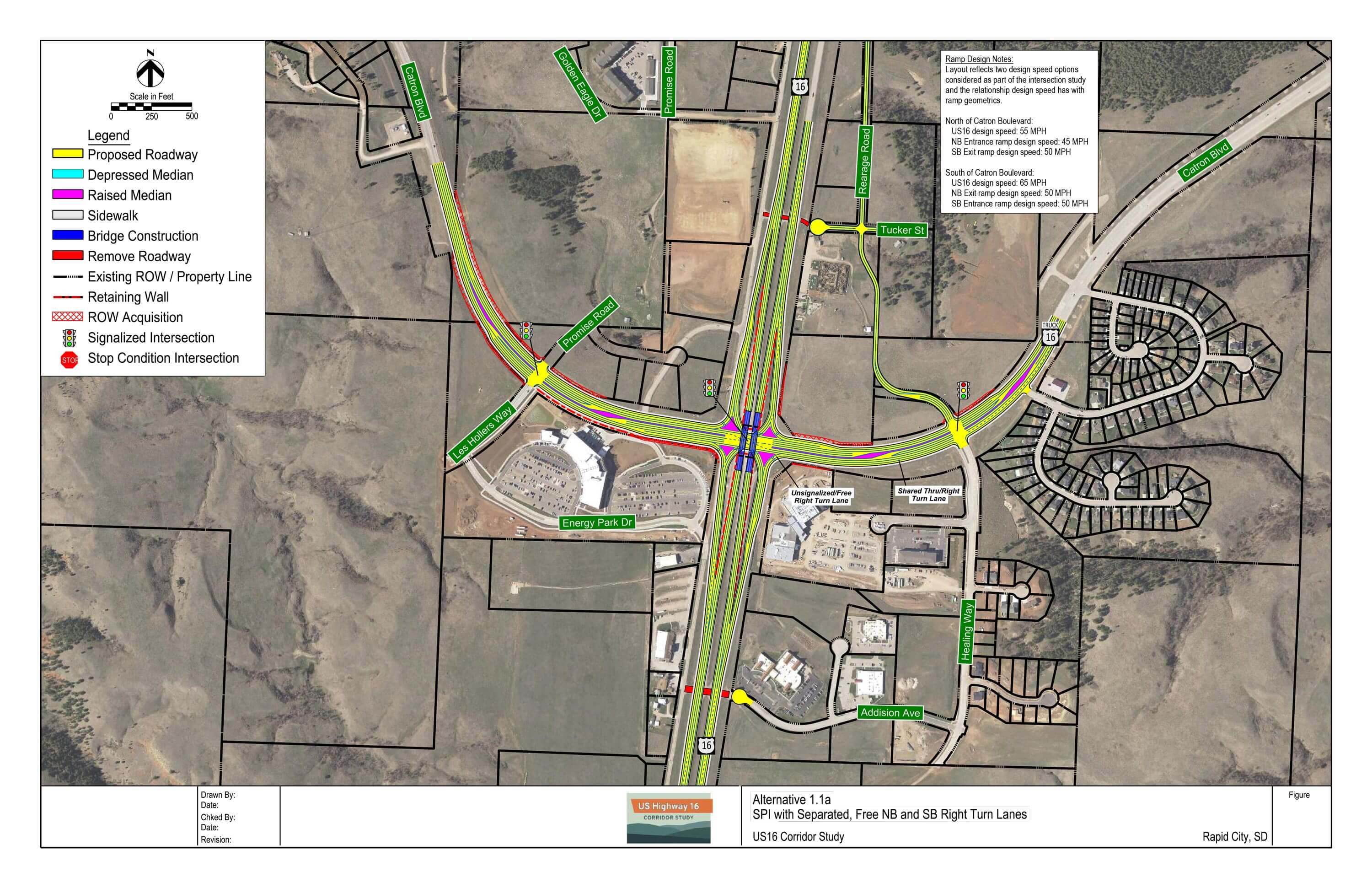
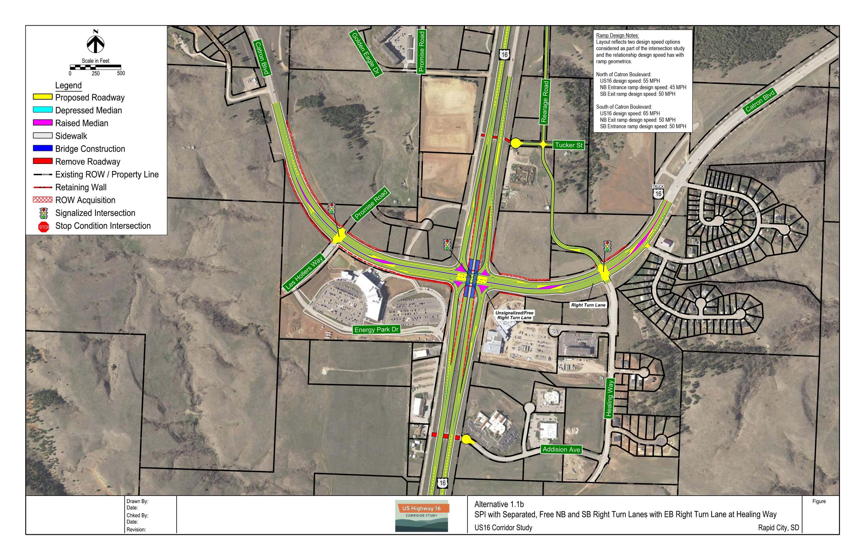
SPI 1.1a: SPI with Separated, Free NB and SB Right Turn Lanes
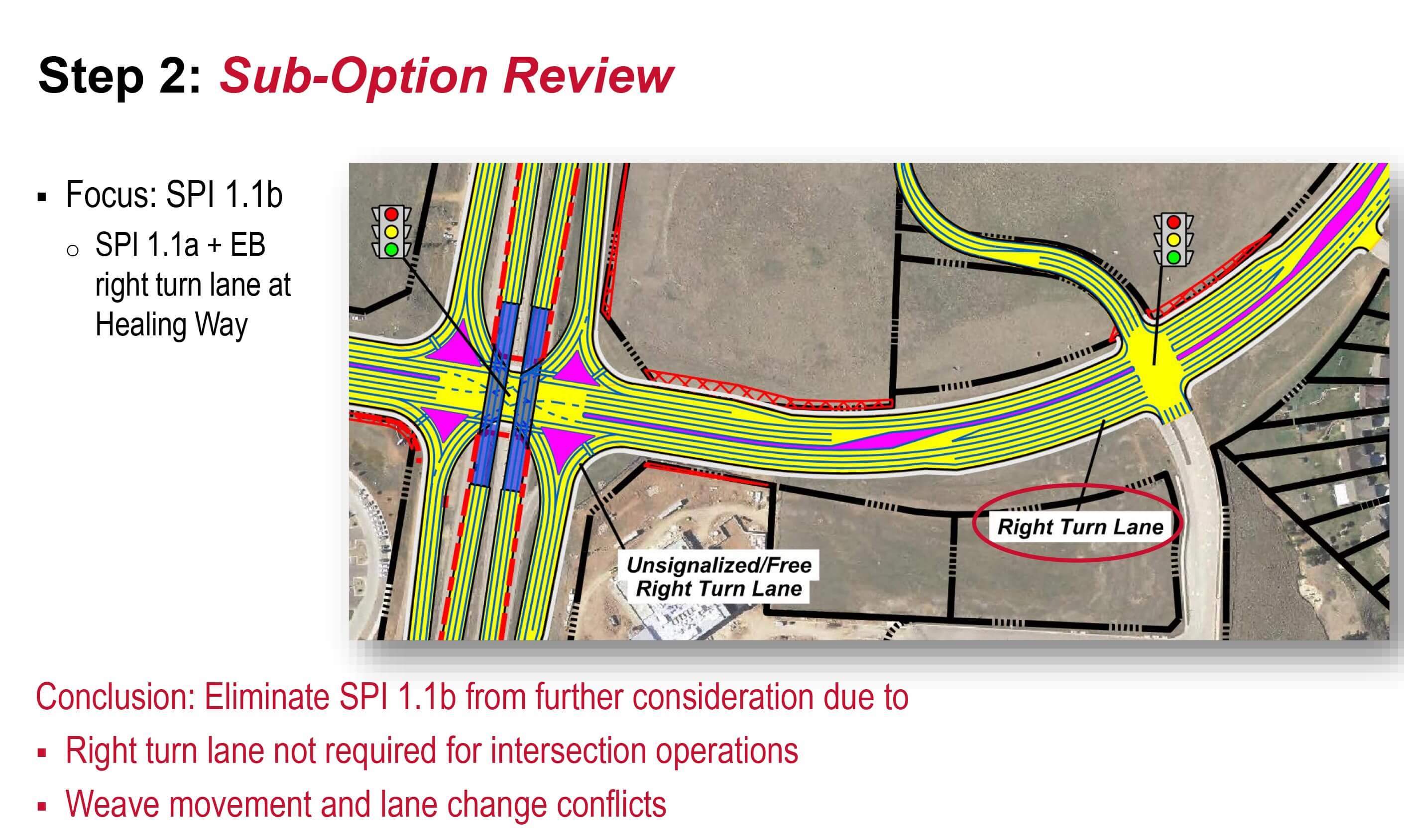
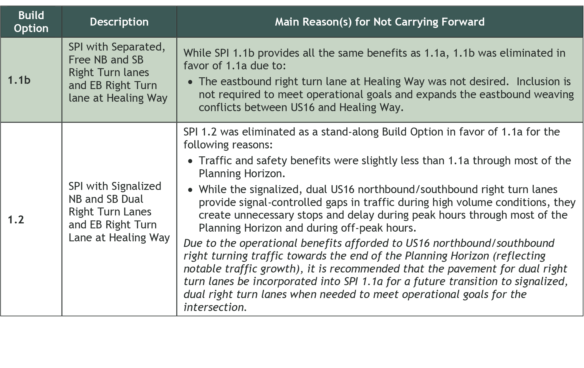
SPI 1.1b: SPI with Separated, Free NB and SB Right Turn lanes and EB Right Turn lane at Healing Way
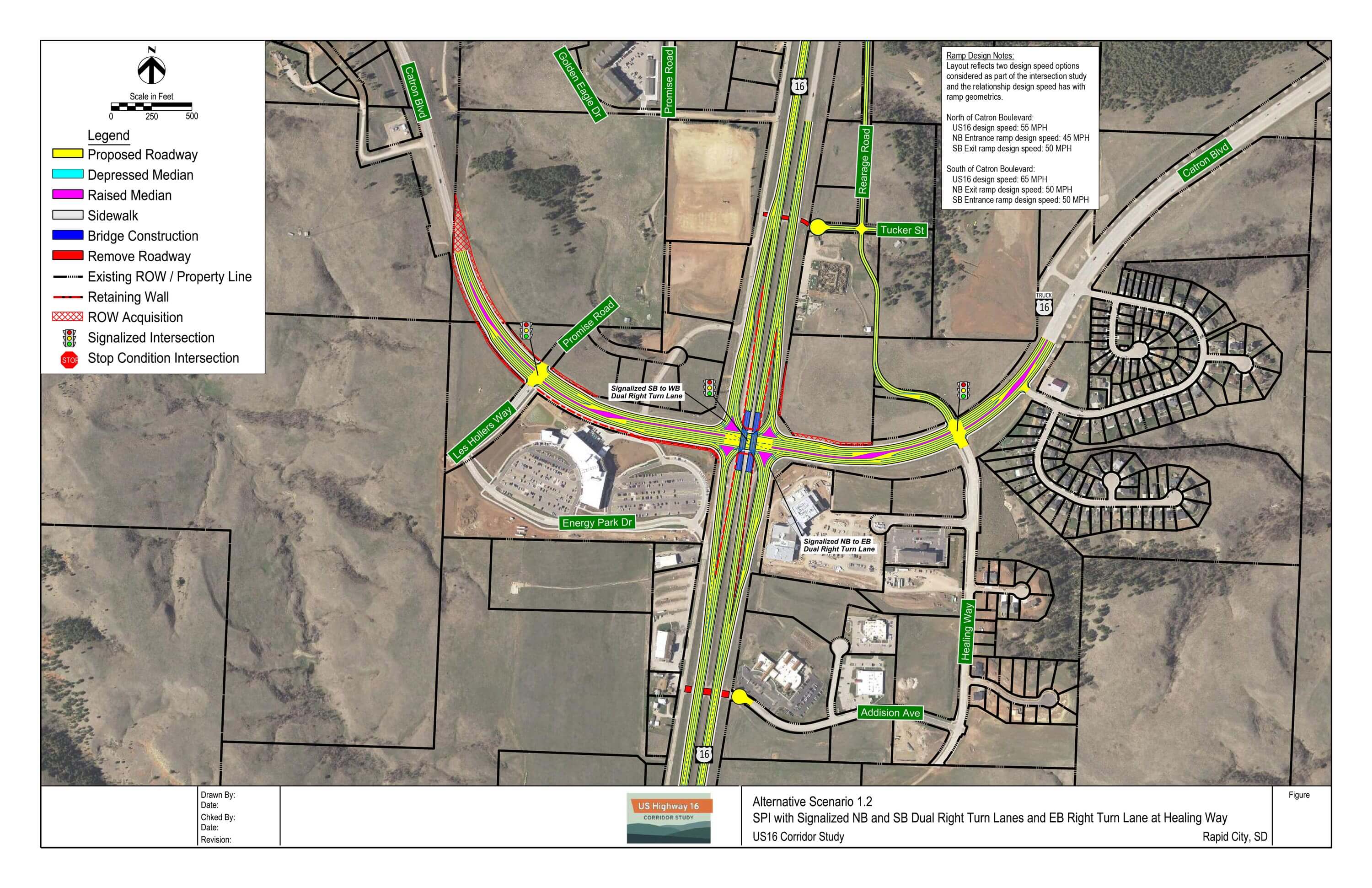
SPI 1.2: SPI with Signalized NB and SB Dual Right Turn Lanes and EB Right Turn Lane at Healing Way
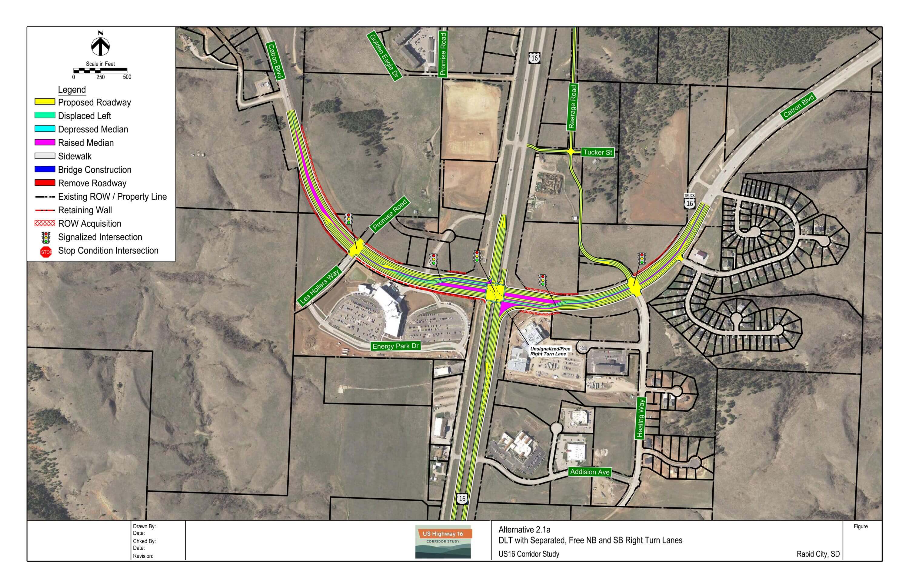
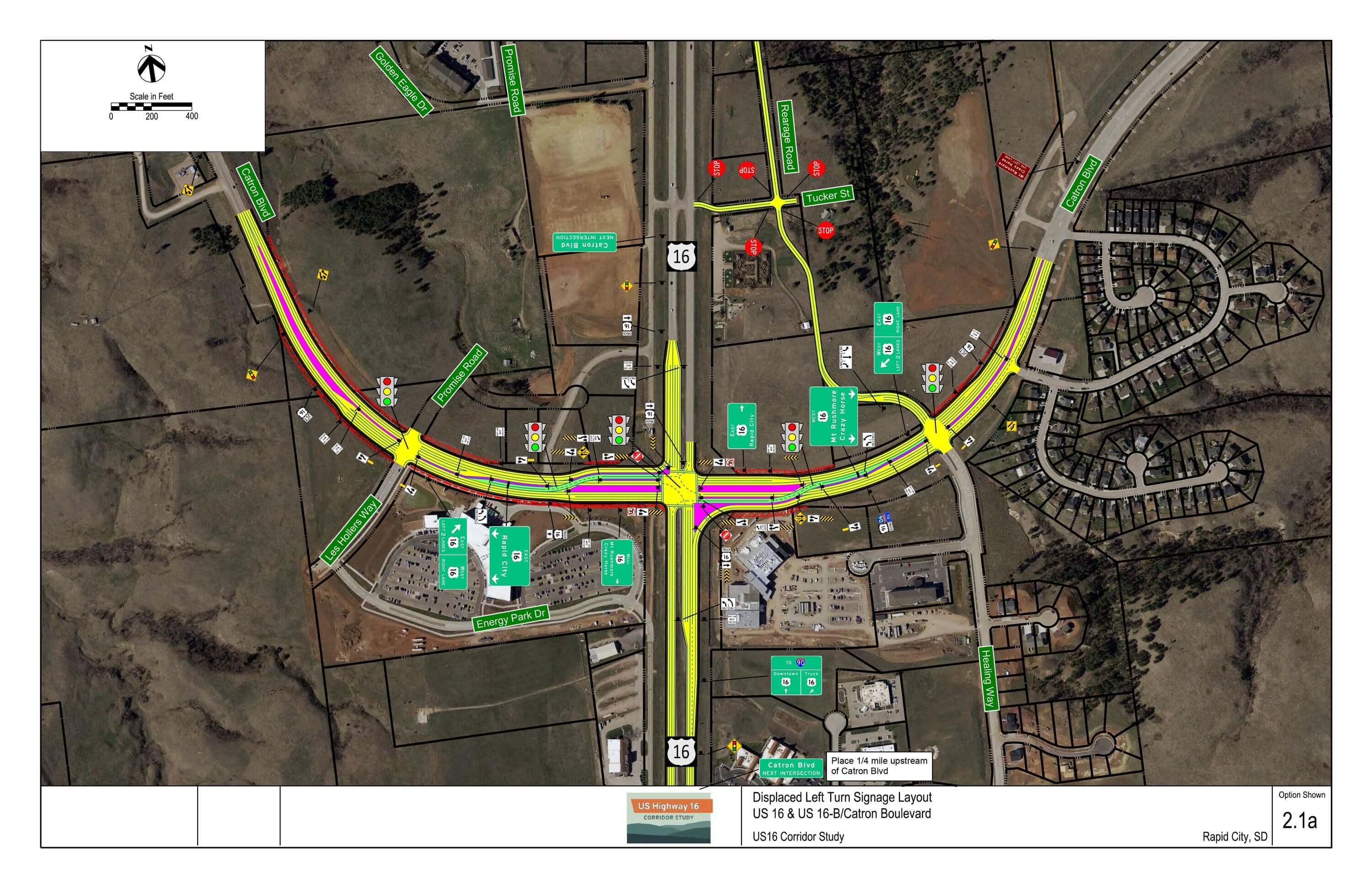
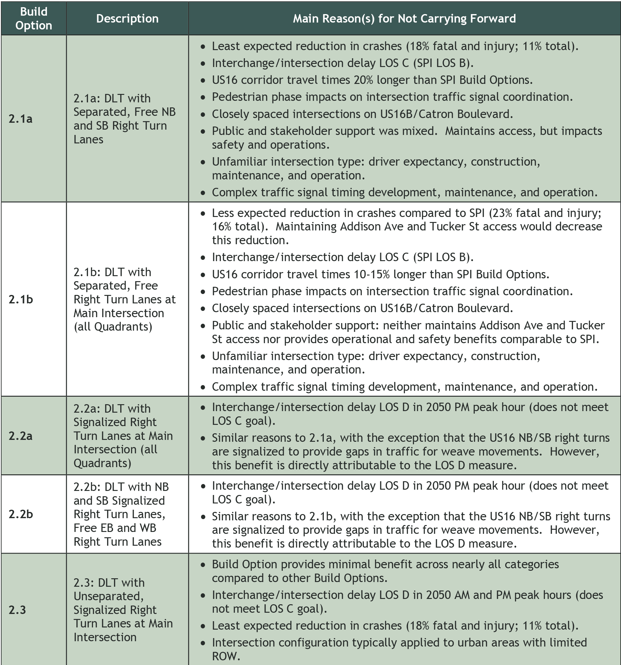
DLT 2.1a: DLT with Separated, Free NB and SB Right Turn Lanes
DLT 2.1b: DLT with Separated, Free Right Turn Lanes at Main Intersection (all Quadrants)

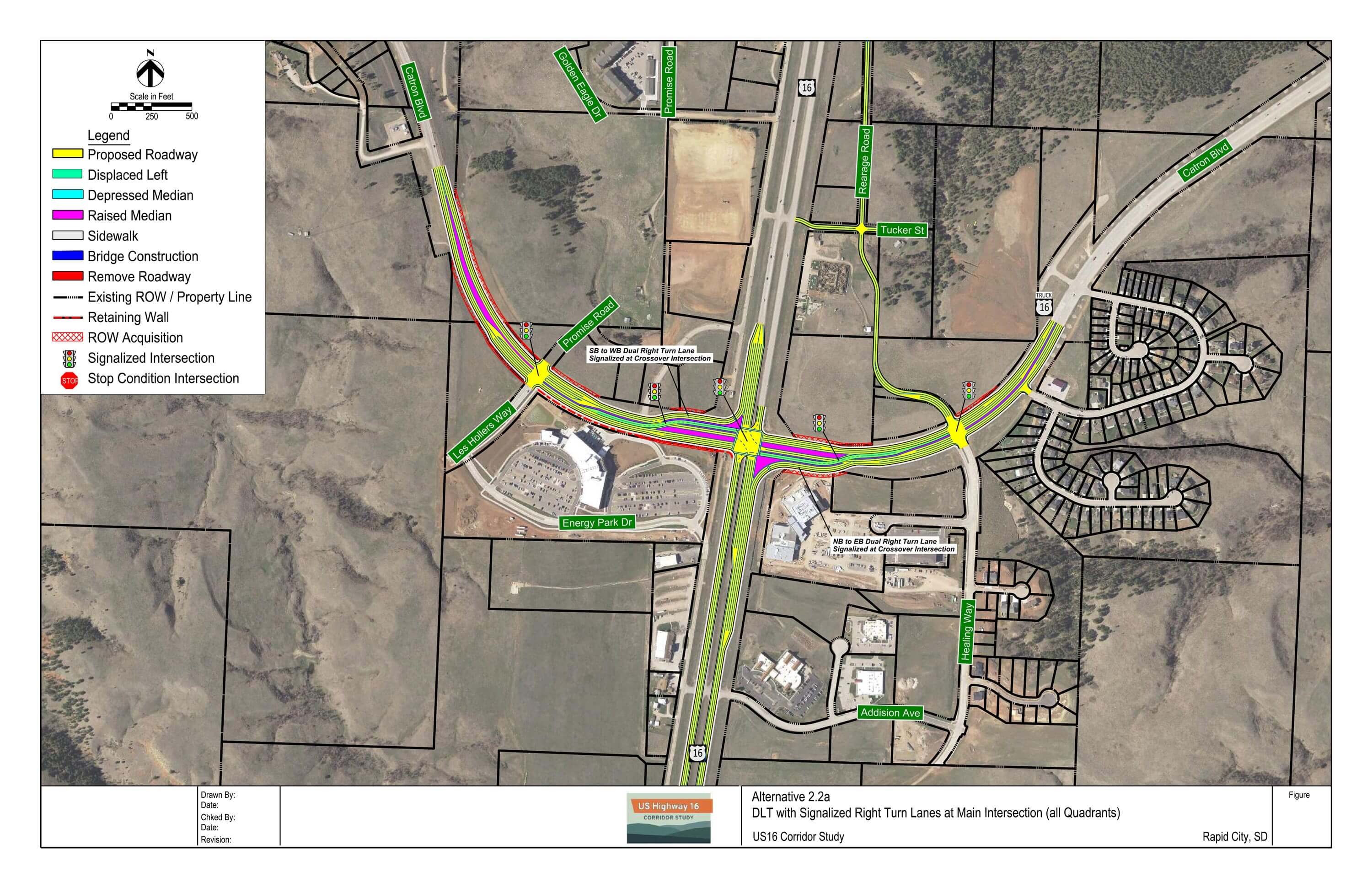
DLT 2.2a: DLT with Signalized Right Turn Lanes at Main Intersection (all Quadrants)
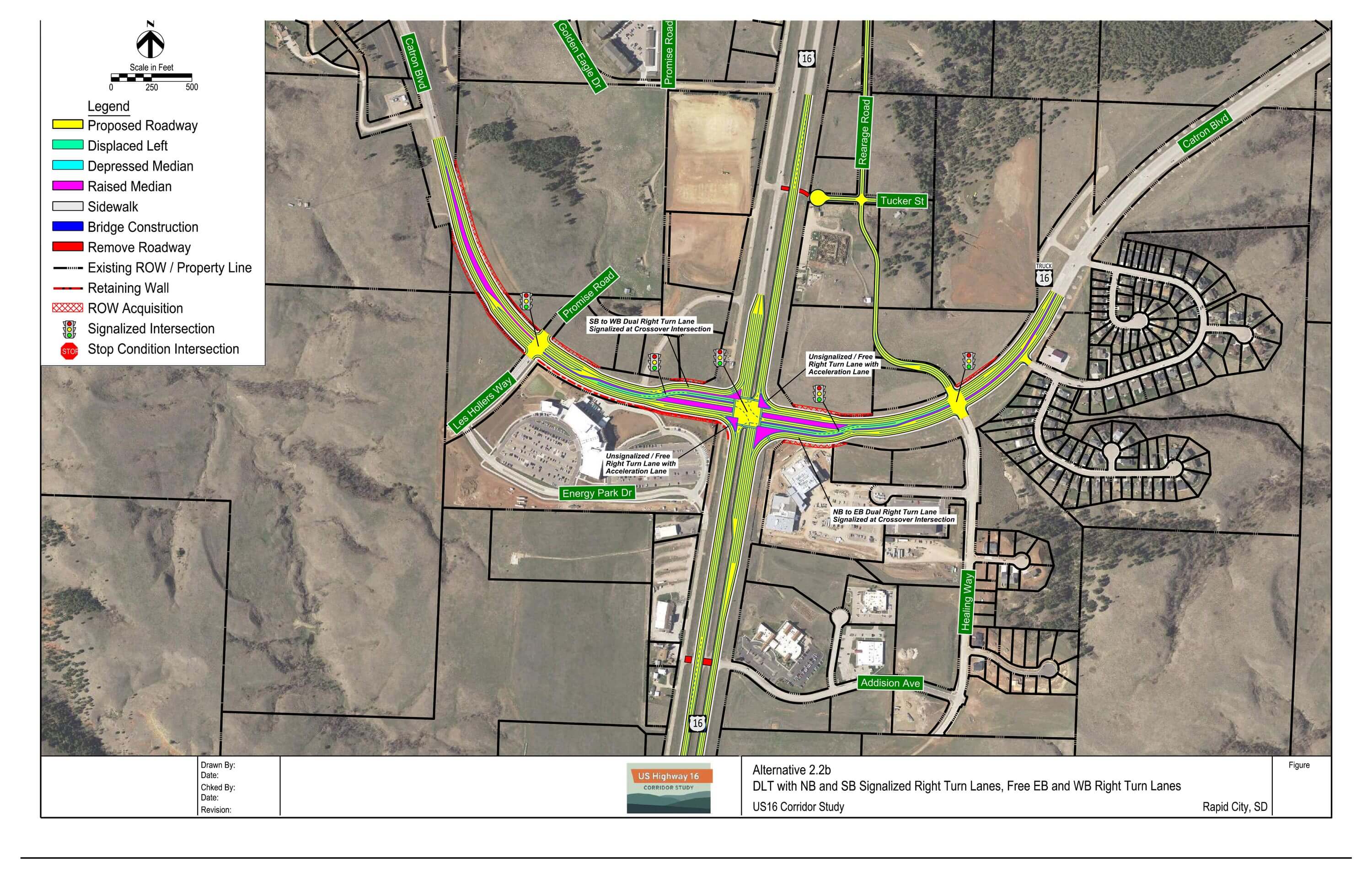
DLT 2.2b: DLT with NB and SB Signalized Right Turn Lanes, Free EB and WB Right Turn Lanes
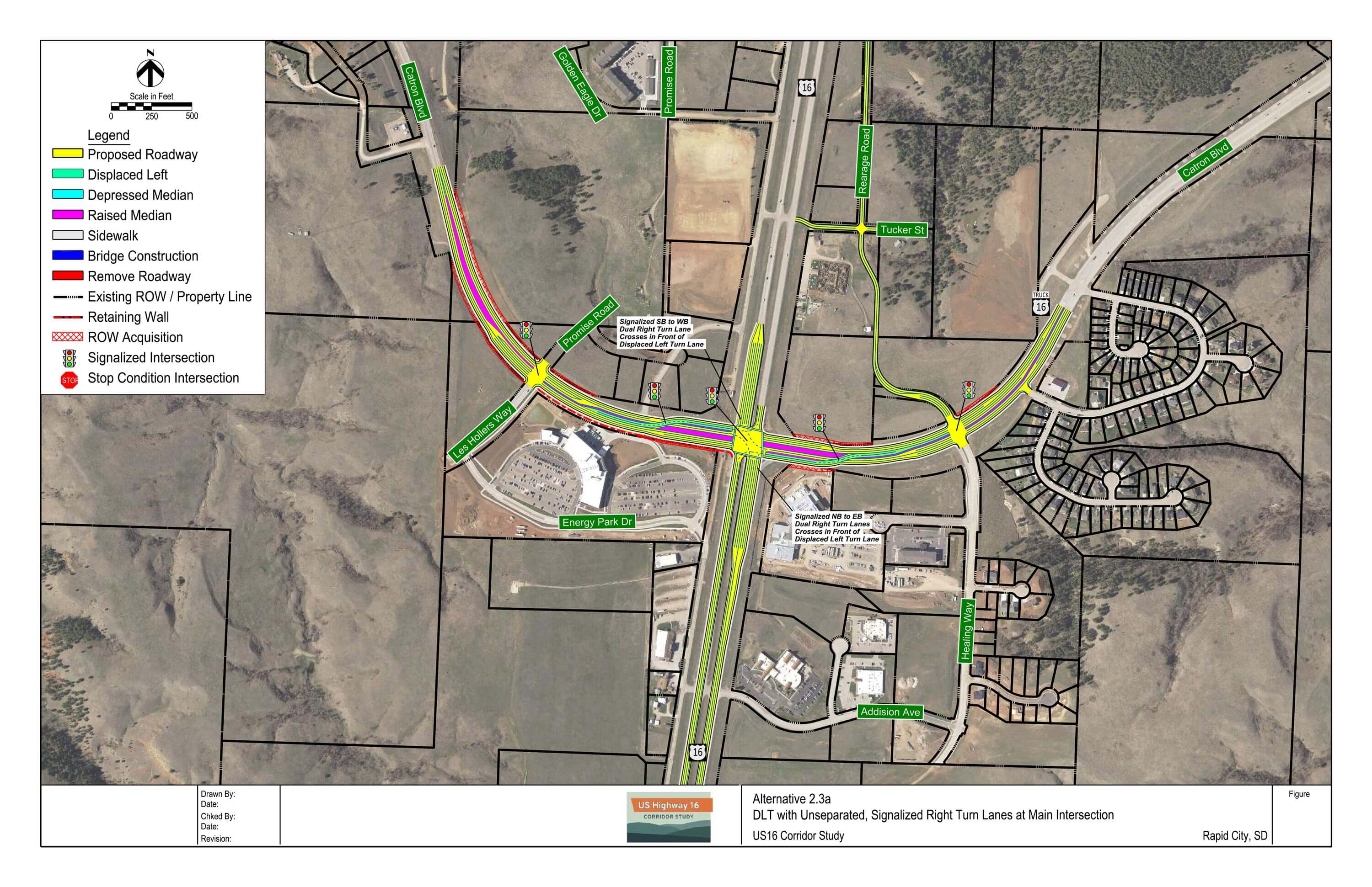
DLT 2.3: DLT with Unseparated, Signalized Right Turn Lanes at Main Intersection
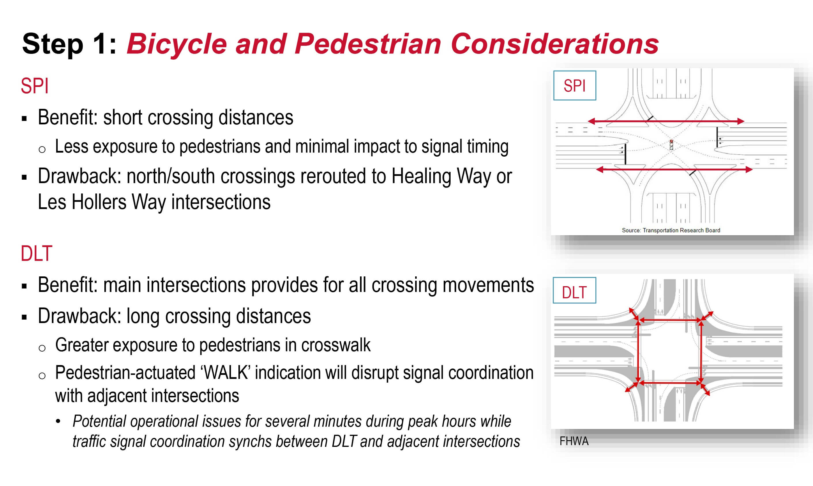
Single Point Interchange (SPI) Key Features
 |
- Grade-separated interchange
- US16 over US16B/Catron Boulevard
- ‘Uninterrupted’ flow on US16
- Signalized intersection on US16B/Catron Boulevard (below US16)
- Provides greatest separation from Les Hollers Way and Healing Way
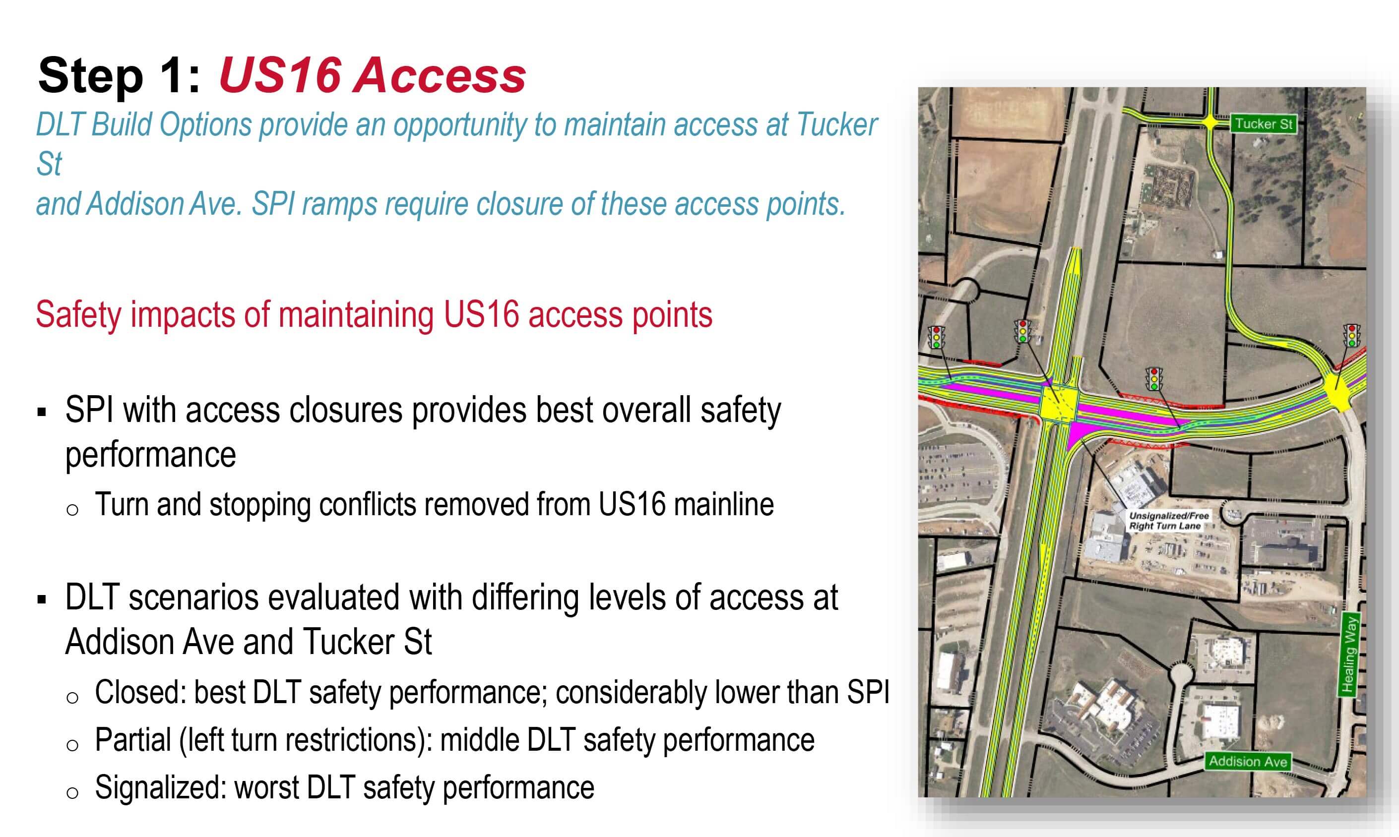
- US16 intersections with Tucker Street and Addison Avenue closed
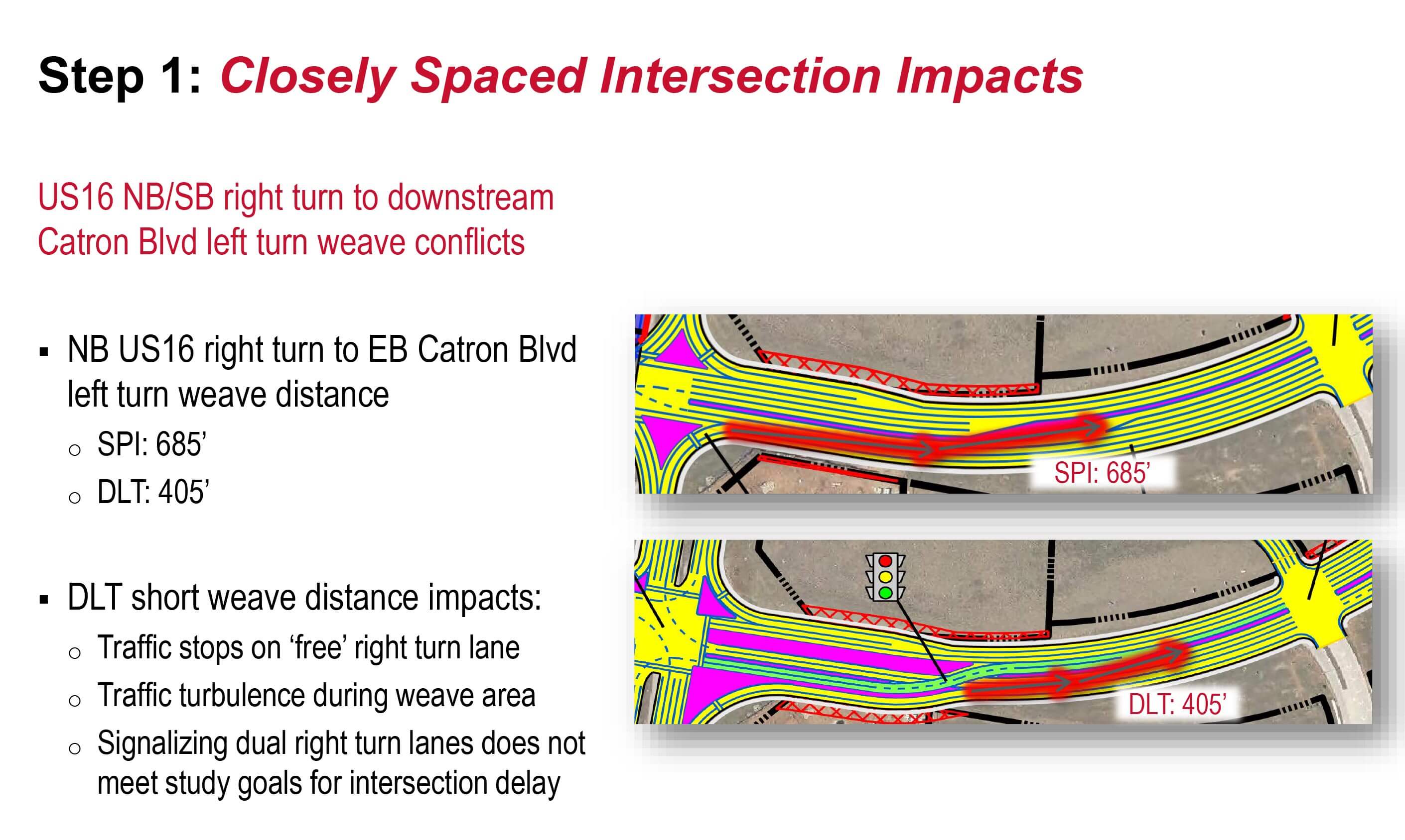
- Primary differences center on treatment of NB and SB US16 right turn lanes at the single point intersection
Displaced Left Turn (DLT) Intersection Key Features
|
- At-grade, signalized intersection
- US16B/Catron Boulevard left turns occur at upstream crossover intersection
- This is a benefit to main intersection signal timing and overall operations
- ‘Interrupted’ flow on US16
- US16 north/south traffic may need to stop at traffic signal
- Provides least separation from Les Hollers Way and Healing Way
- Primary differences center on treatment of DLT main intersection right turn lanes
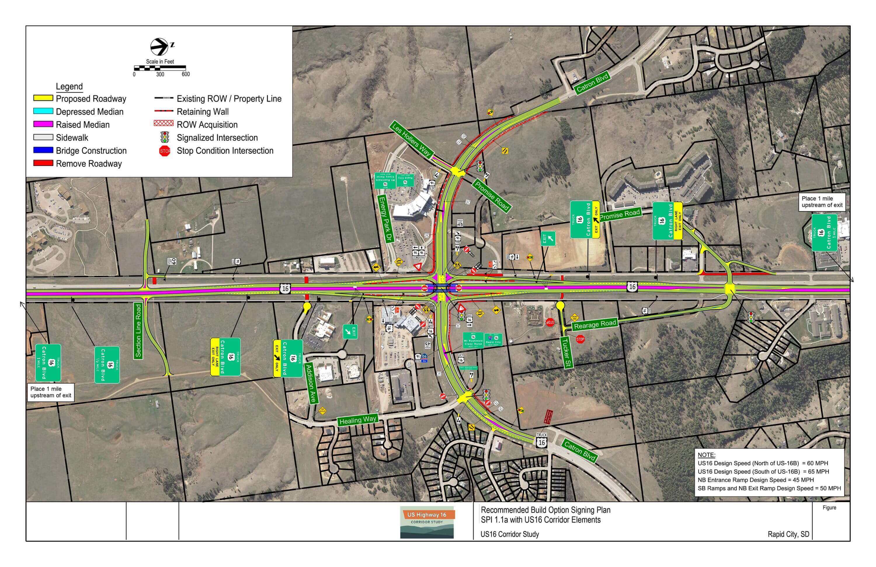
Signing Plans – Download PDF
Conceptual signing plans were developed for both an SPI and DLT intersection Build Option to help assess the ability to sign and potential driver expectancy issues, particularly for tourists who may be unfamiliar to the area.
SPI: US16B/Catron Boulevard signalized intersection spacing allows for guide signage placement between signalized intersections (i.e. Les Hollers Way and Healing Way). This location is in advance of the SPI queues to provide ample maneuver distance in response to the signage.
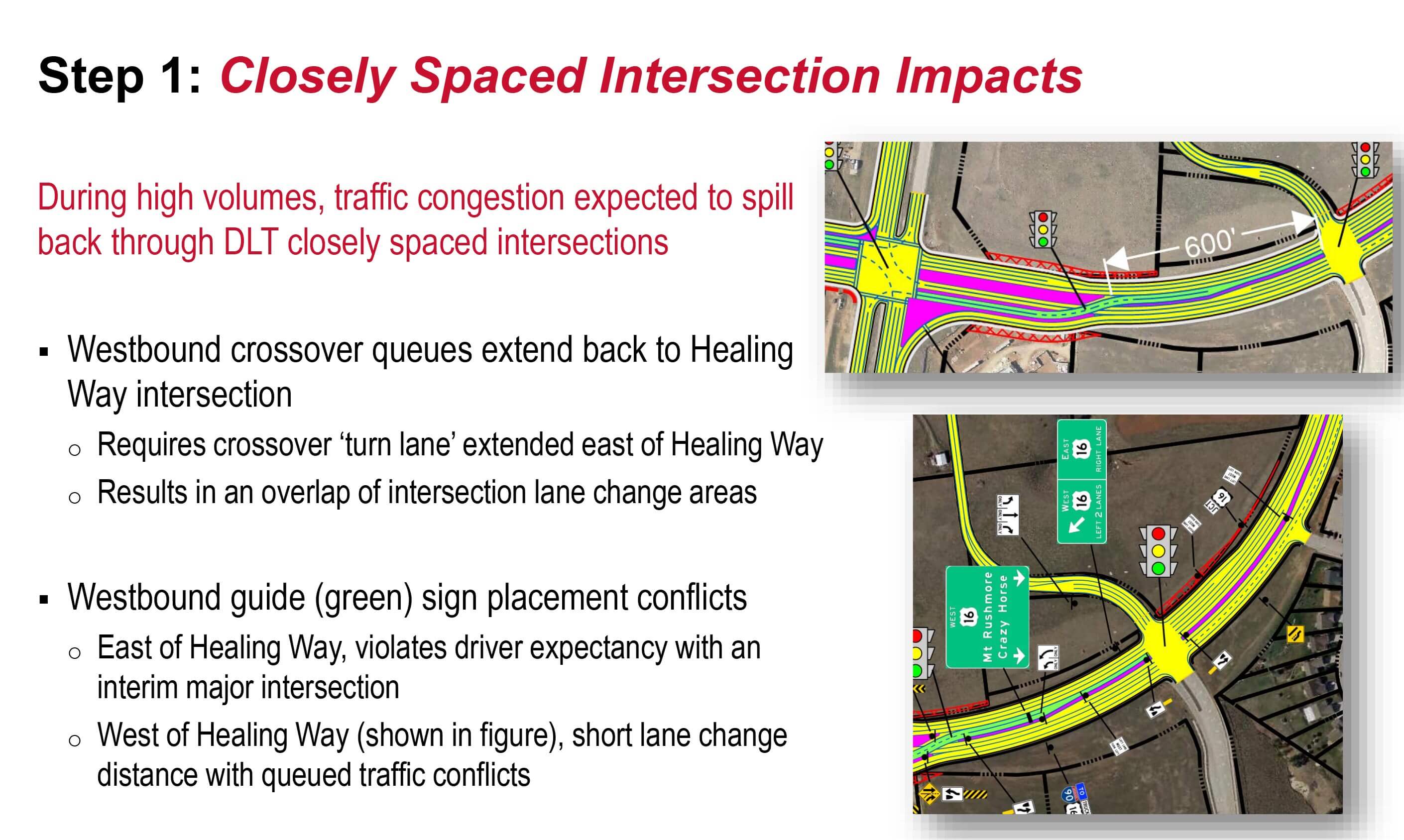
DLT: closely spaced intersections along US16B/Catron Boulevard requires guide signs to either be placed with little advance notification of a required turn at the DLT crossover intersections or located at least one signalized intersection prior. This may create issues with queue blockages extending through the area where guide signage is located, necessitating lane change maneuvers well upstream of the guide sign location.
Environmental Considerations
US16/16B/Catron Boulevard Intersection
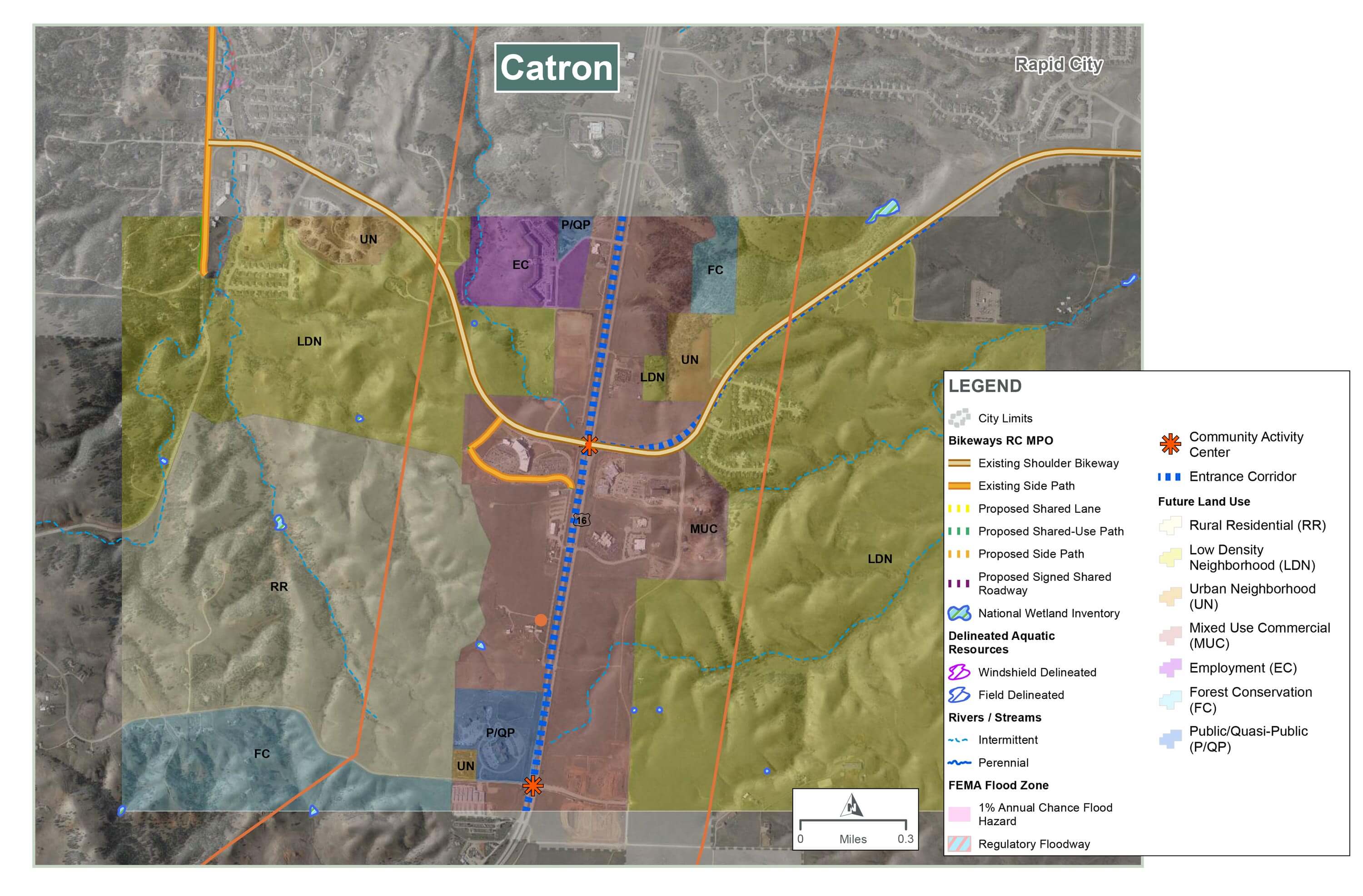
Water Resources:
- No wetlands, streams, or floodplains are present
Socioeconomic:
- Future land use designated as mixed use commercial with several employers
- US 16 is considered an Entrance Corridor for Rapid City
- Bicycle and pedestrian accommodations are being coordinated with Rapid City Area MPO planning efforts
- No environmental justice populations present
Cultural Resources:
- Three historic-age properties need to be evaluated for NRHP eligibility
Hazardous Materials:
- Active underground storage tank (UST) site (Holiday Gas Station)
Noise:
- One area with measured noise above 66 dBA (see map)
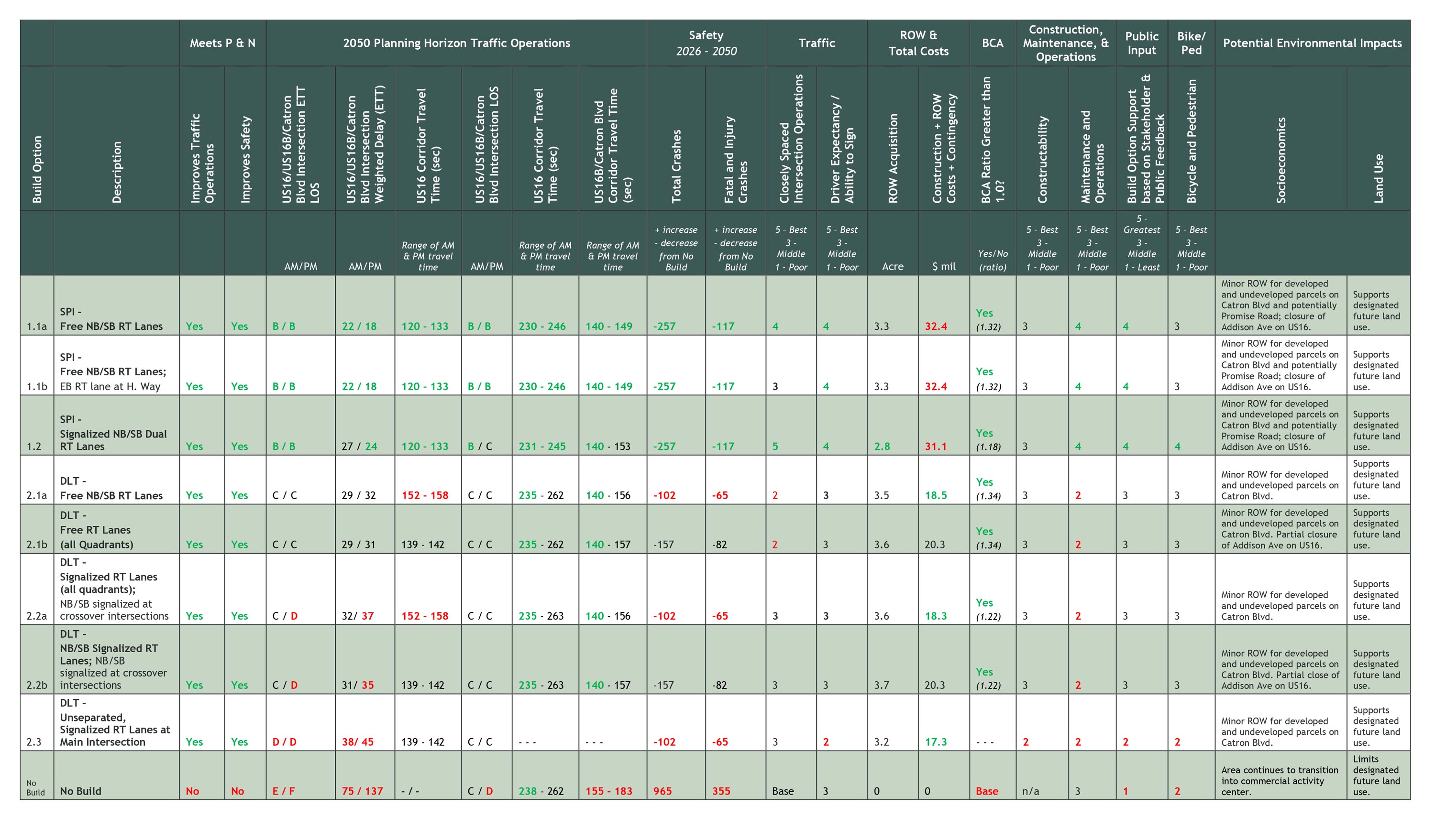
Evaluation Matrix Summary
Each concept was evaluated on how they compare with other concepts in a given category and/or whether they meet study goals. This evaluation is summarized through the following color coding in the evaluation matrix.
- Bold green text indicates a concept measure was favorable compared to the other concepts in a category
- Black text indicates a concept measure was in the middle compared to other concepts in a category
- Bold red text indicates a concept measure was unfavorable compared to the other concepts in a category or the measure does not meet study goals
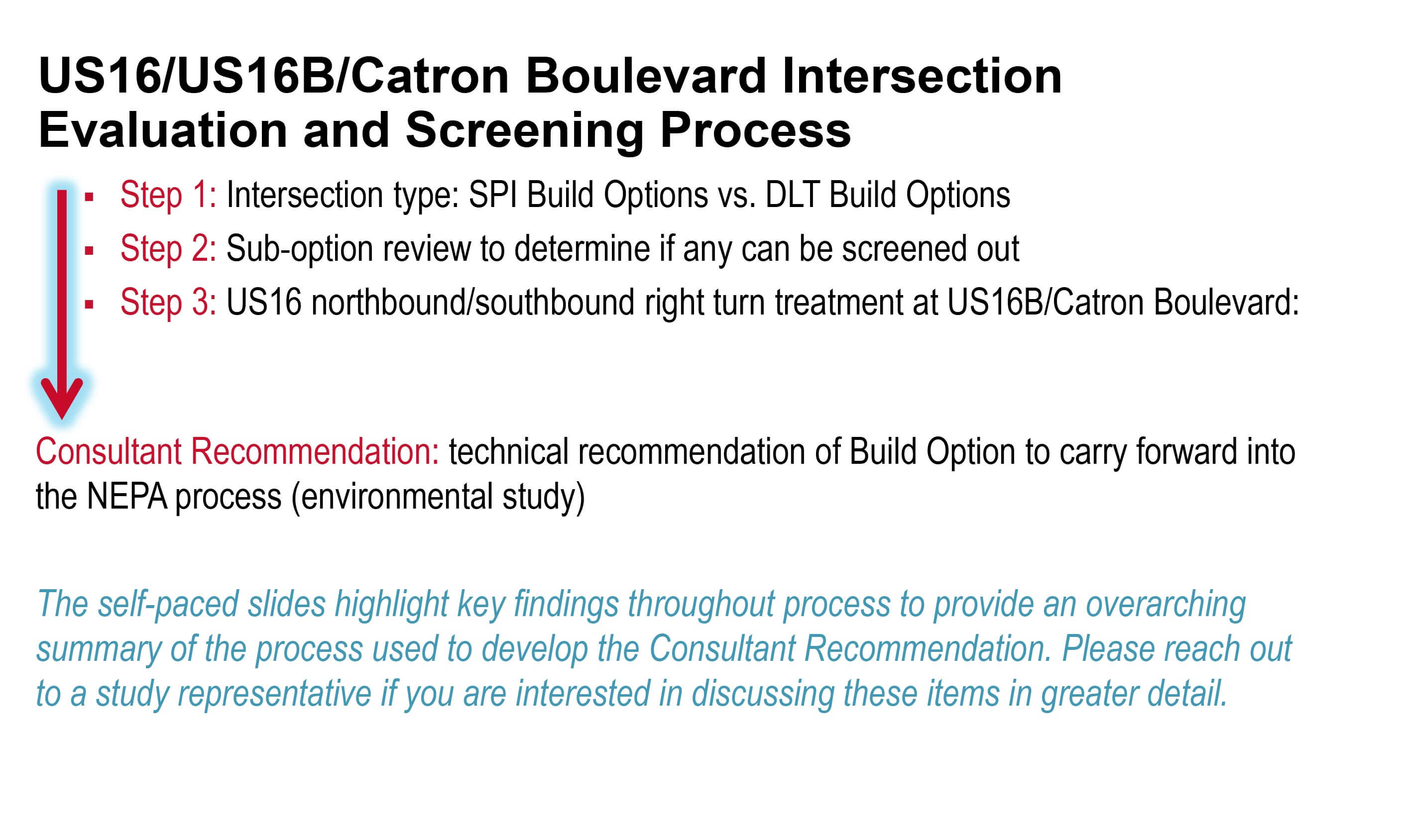
Evaluation and Screening Process Summary – Download PDF
3-Step Process:
- Intersection type: SPI Build Options vs. DLT Build Options
- Sub-option review to determine if any can be screened out
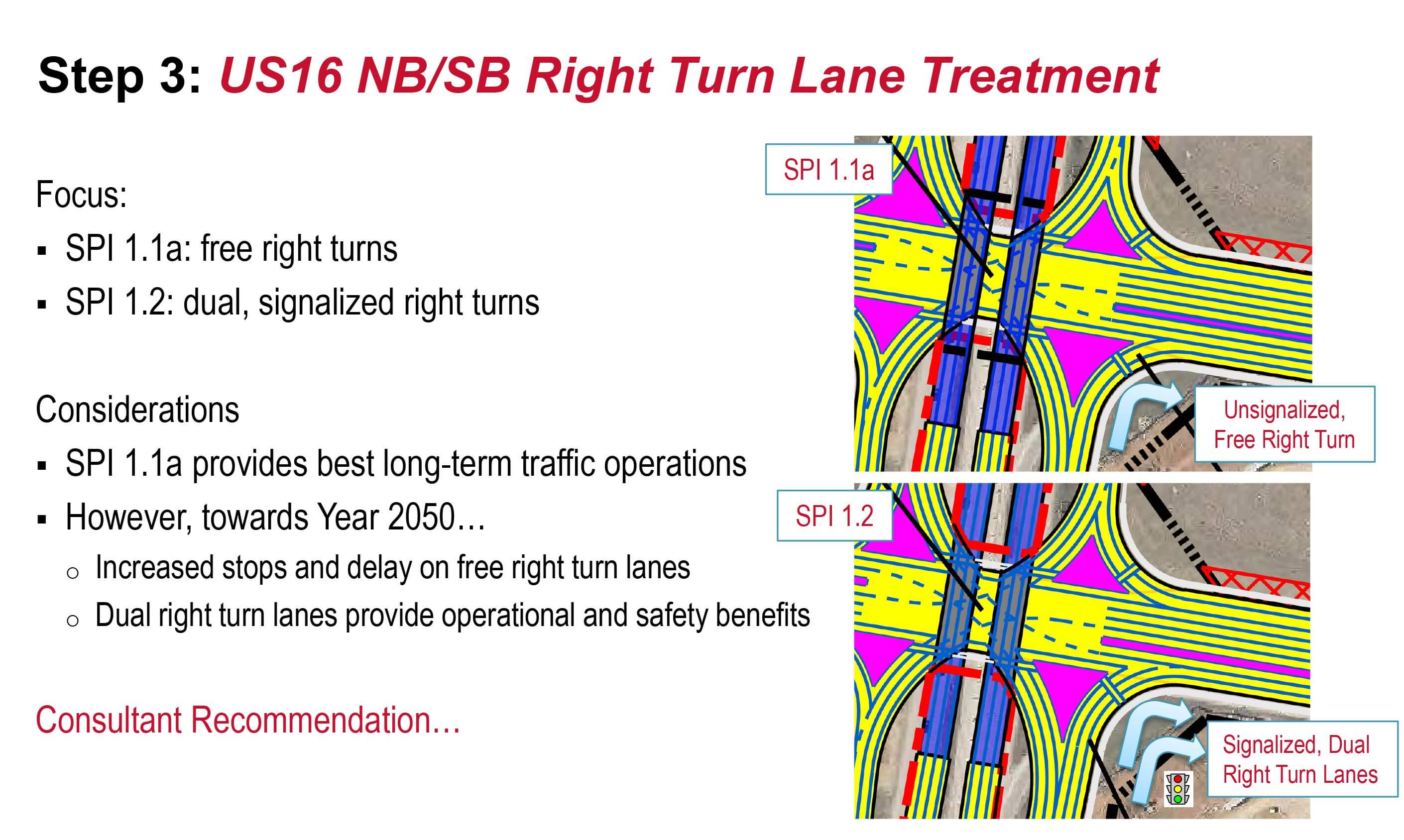
- US16 northbound/southbound right turn treatment at US16B/Catron Boulevard
- Result: Consultant Recommendation. Technical recommendation of Build Option to carry forward into the NEPA process (environmental study).
Overview:
Step 1:
Step 2:
Step 3:
Consultant Recommendation of Technically Feasible Option – Download PDF
Recommendation
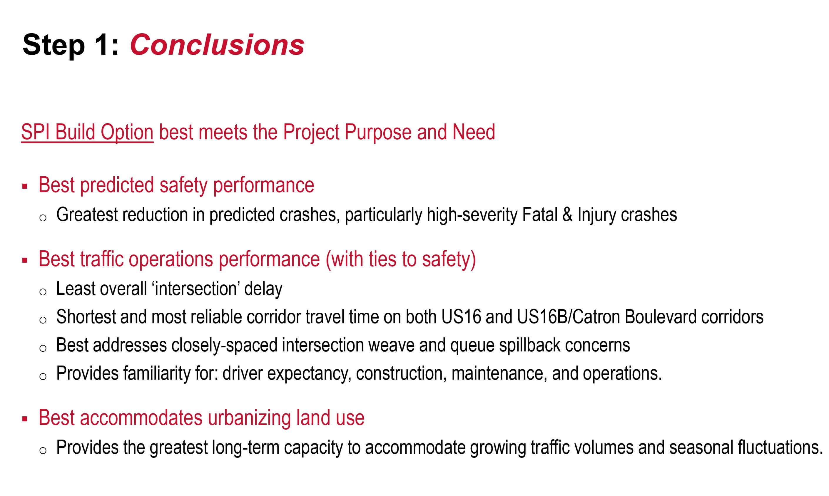
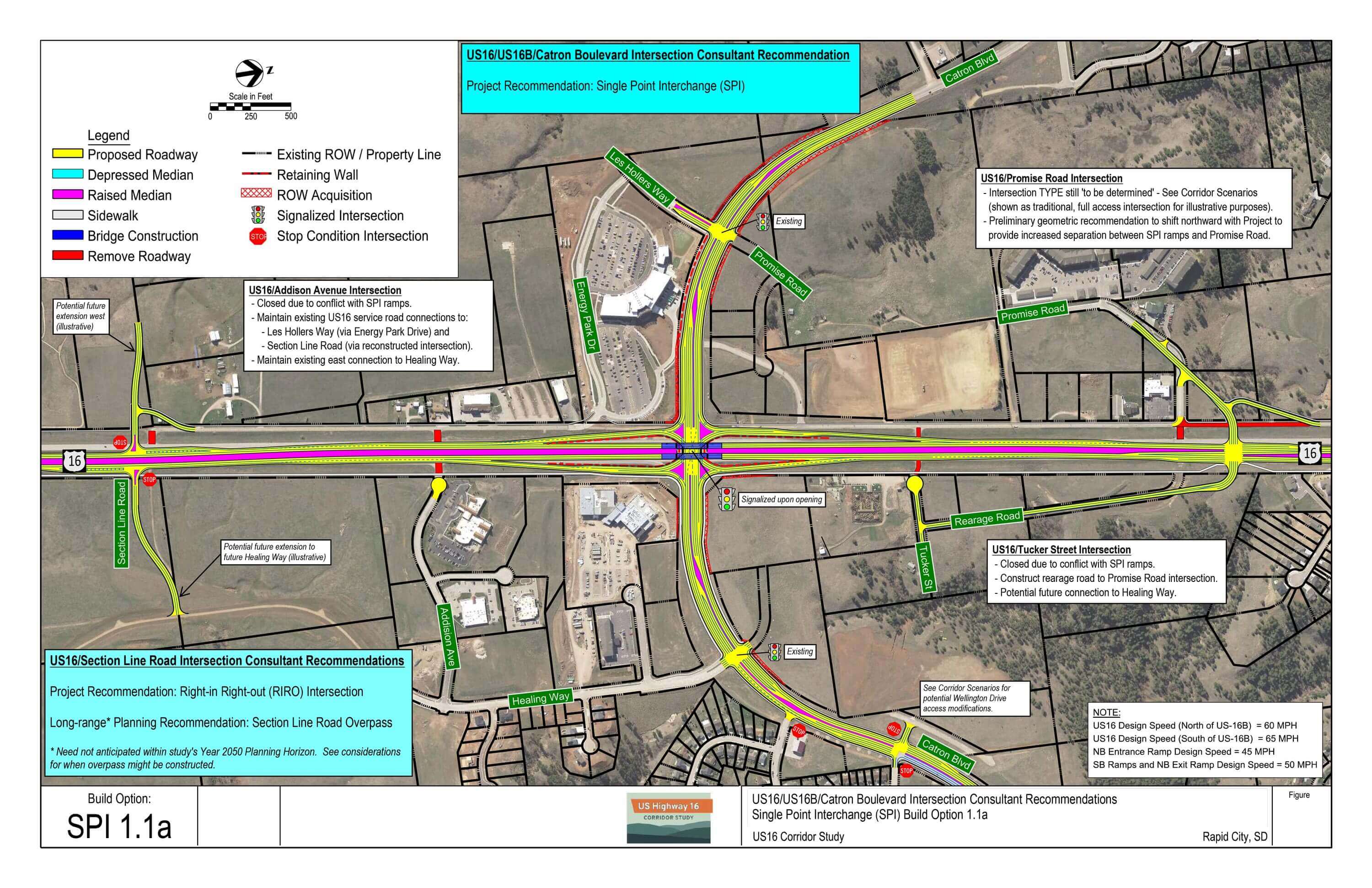
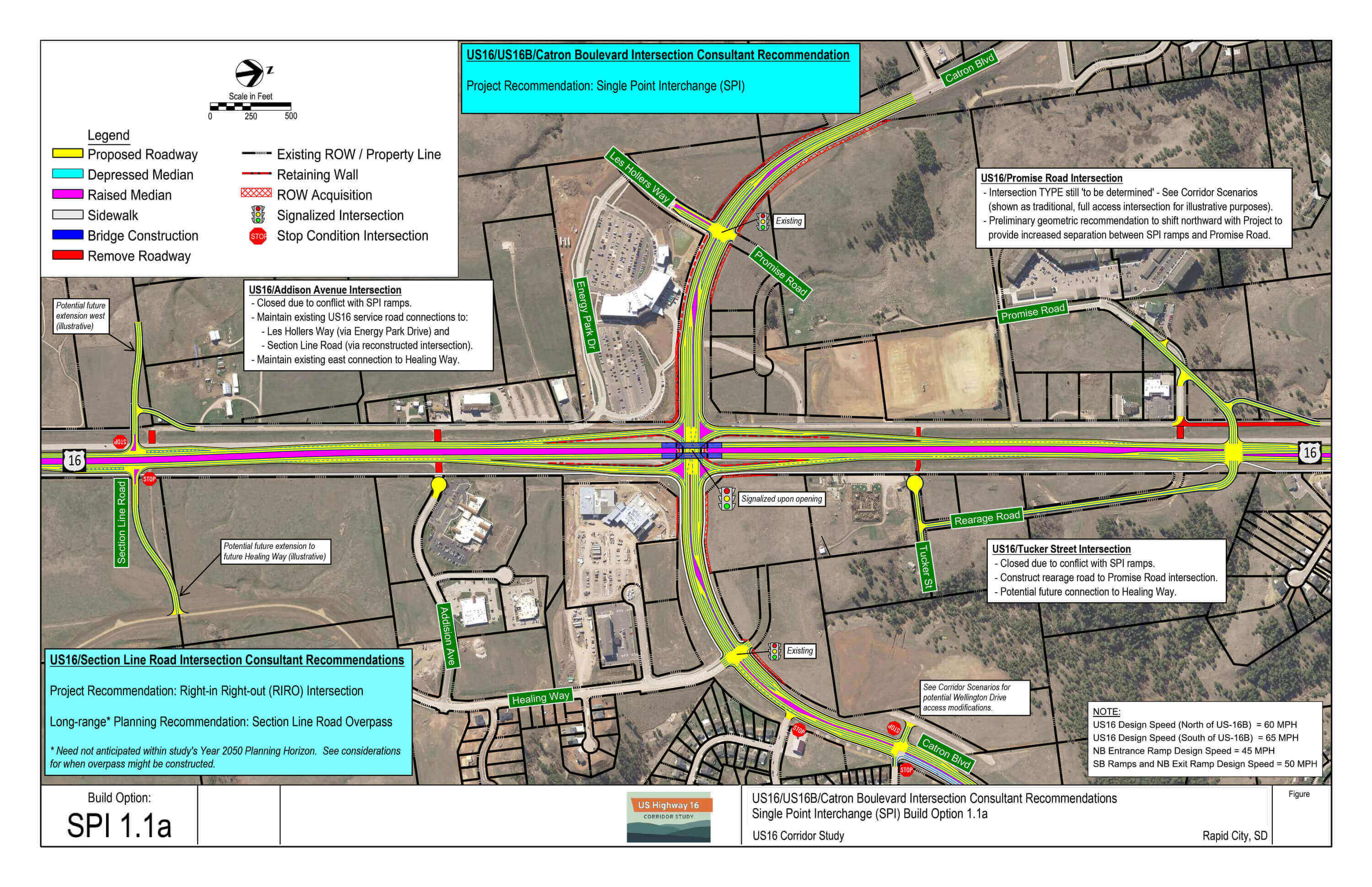
The recommended technically feasible option that best meets the established transportation needs of the US16/US16B/Catron Boulevard intersection is Build Option 1.1a, SPI with separated, free northbound and southbound right turn lanes.
Due to the operational benefits afforded to US16 northbound/southbound right turning traffic towards the end of the Planning Horizon, it is also recommended that pavement for dual right turn lanes shown in SPI 1.2 be incorporated into SPI 1.1a for an easy transition to signalized, dual right turn lanes when needed to meet intersection operational goals.
Key Benefits
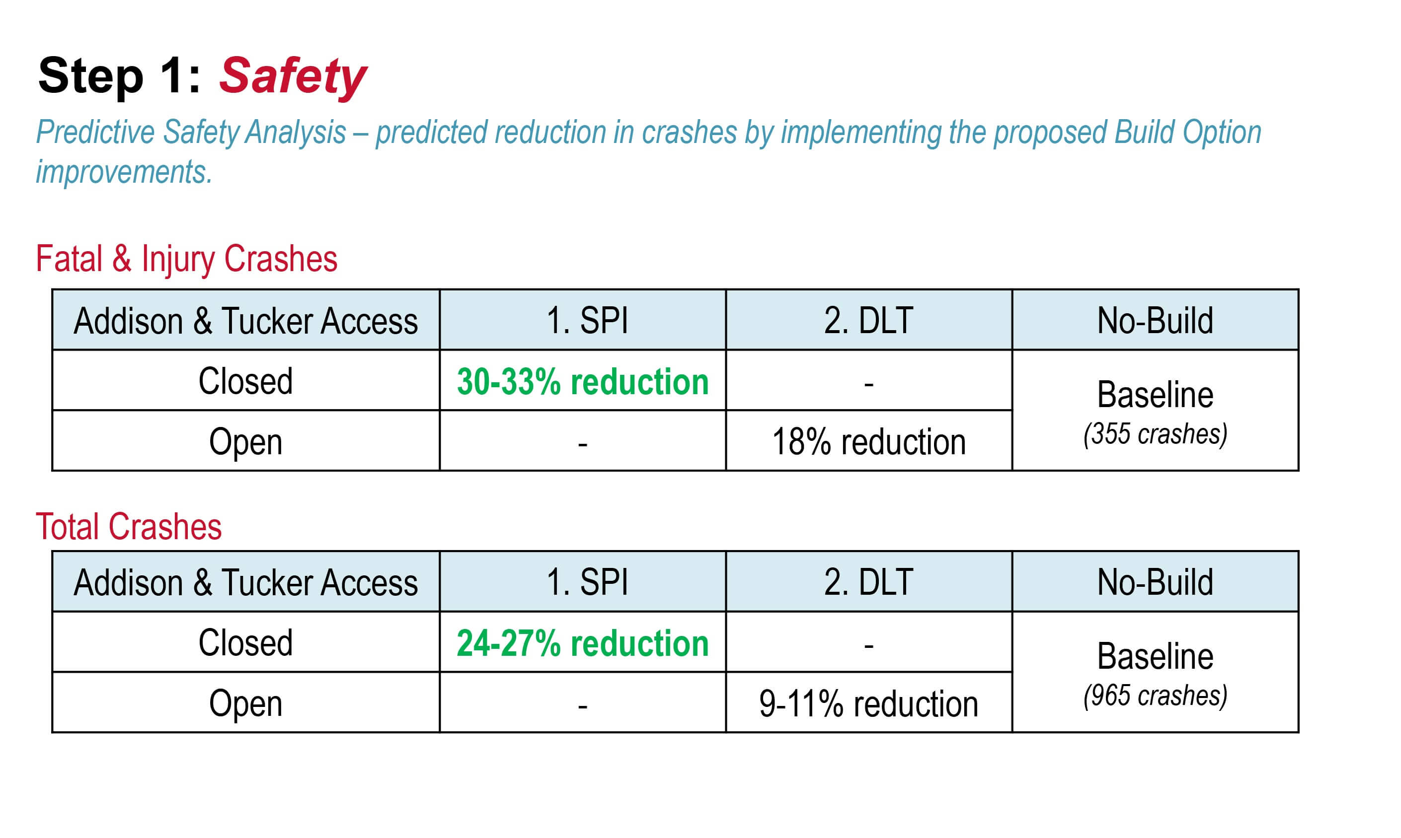
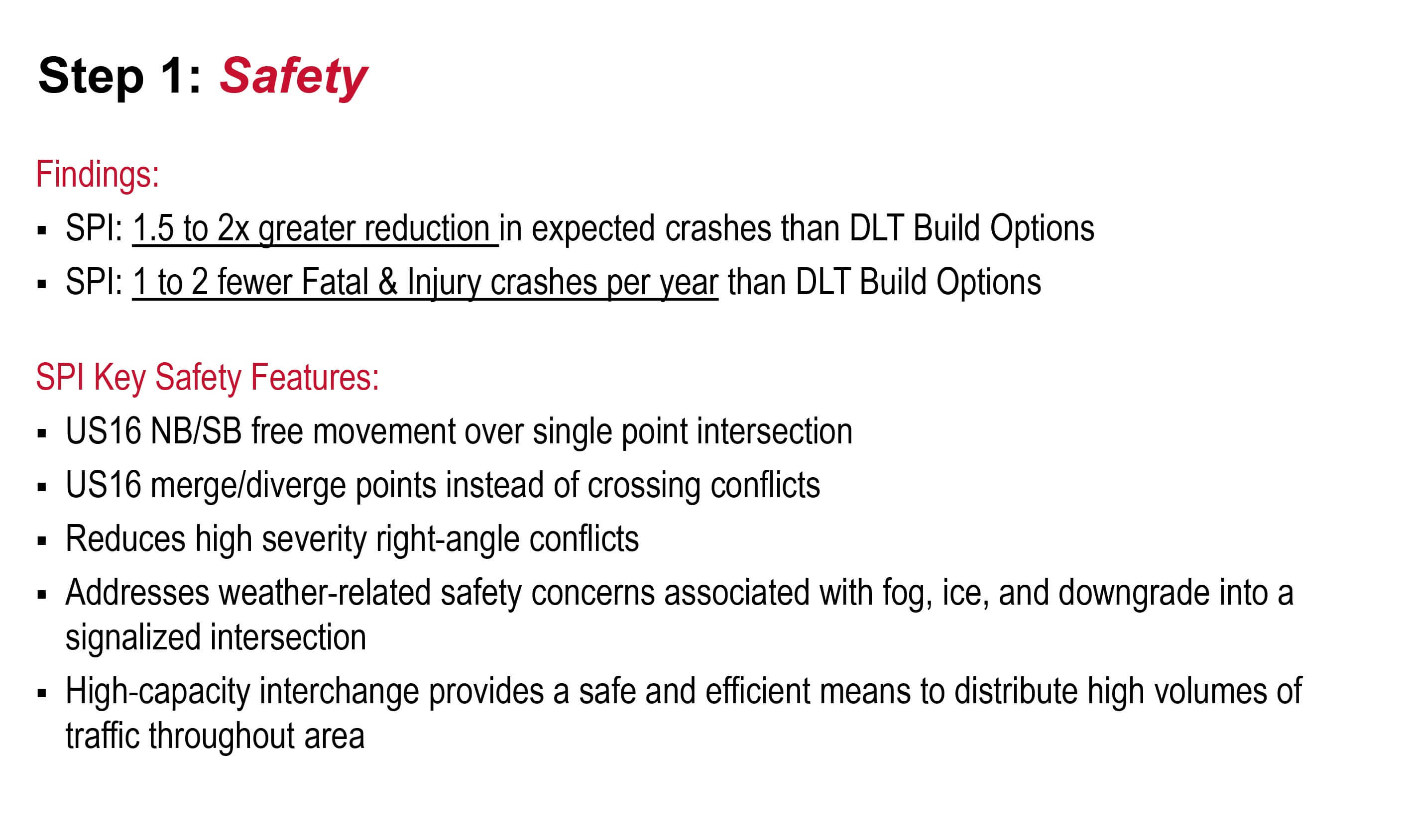
- Greatest expected reduction in crashes (33% fatal and injury; 26% total).
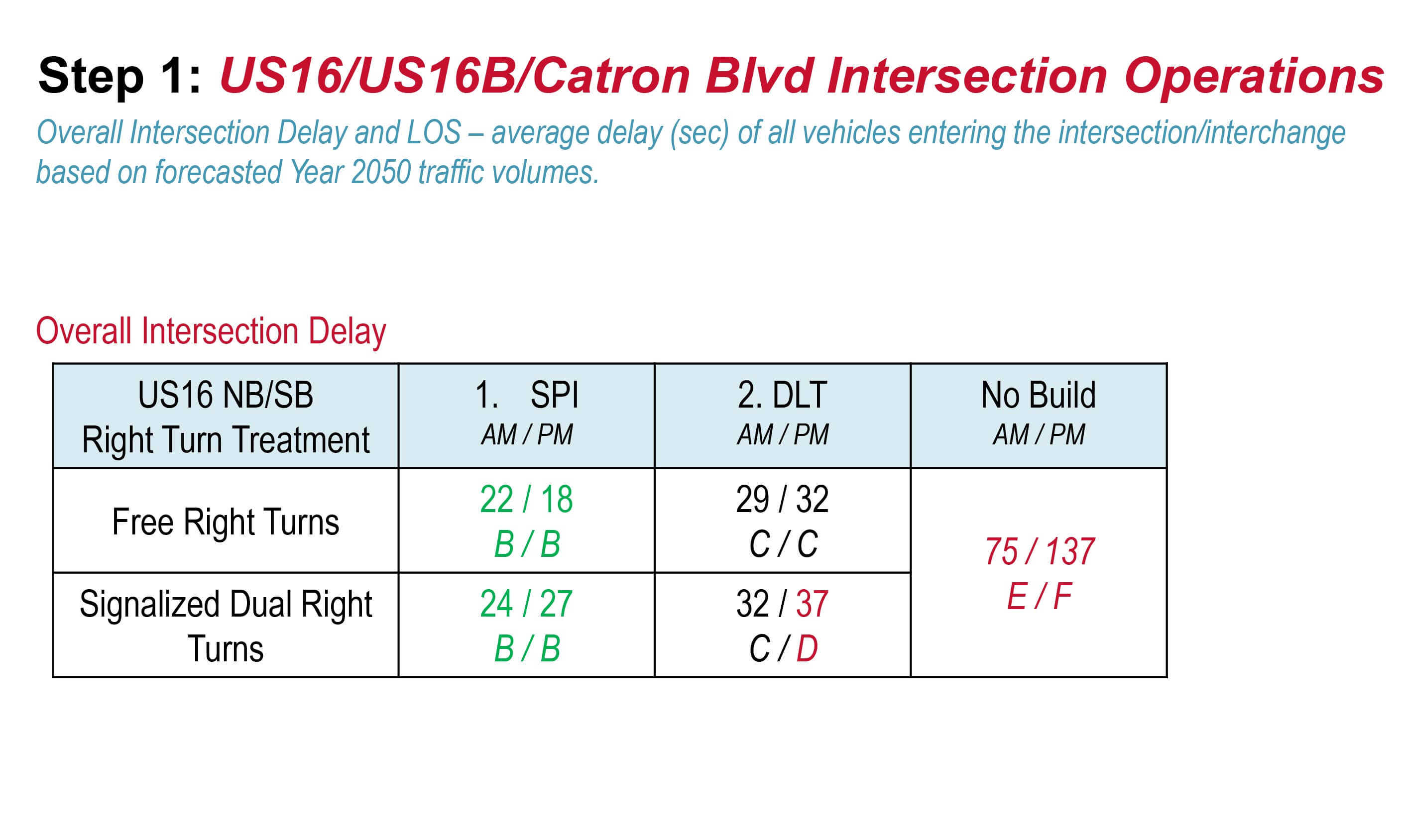
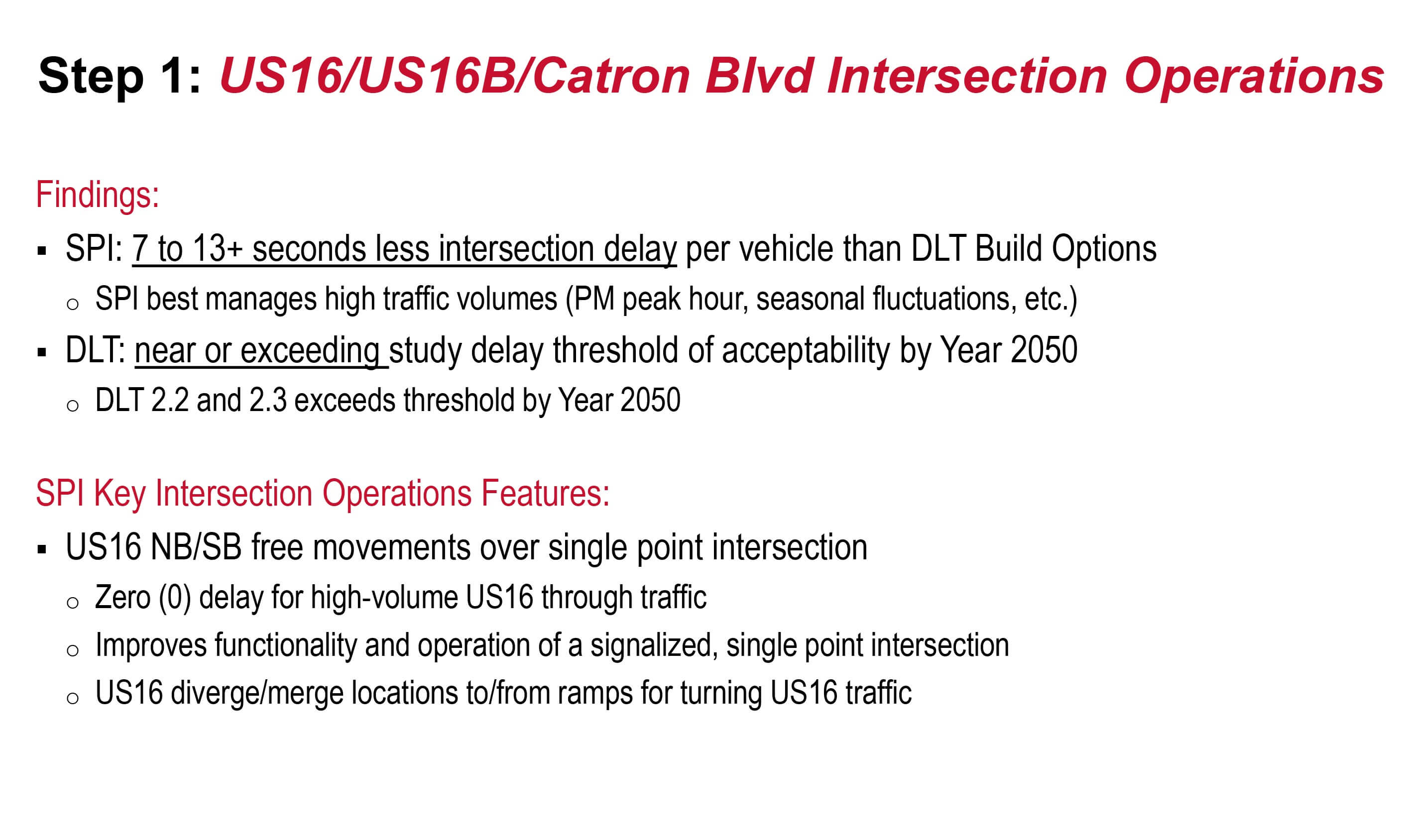
- Lowest overall interchange/intersection delay (LOS B).
- Greatest available capacity to accommodate traffic growth and fluctuations within interchange/intersection.
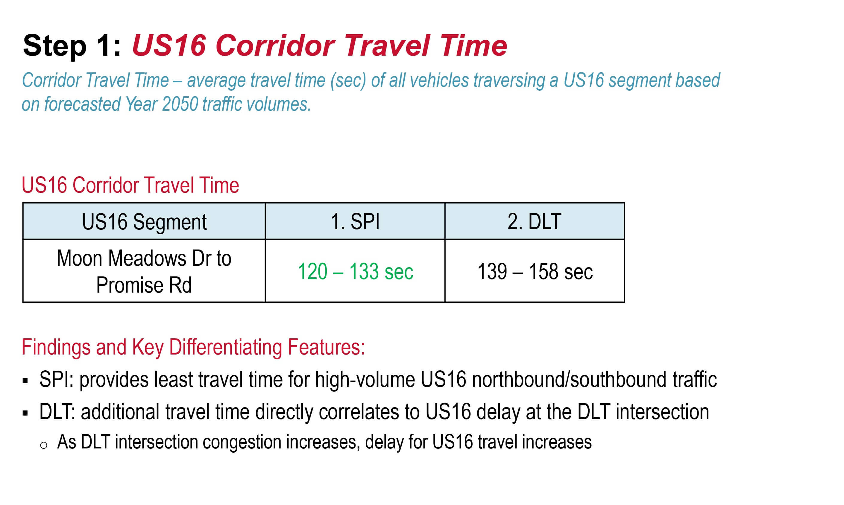
- Shortest travel time along US16 and US16B/Catron Blvd corridors.
- Greatest separation between US16 and next adjacent US16B/Catron Blvd signalized intersections.
- Best addresses US16B/Catron Blvd weave concerns without degrading overall intersection/interchange operations.
- Public and stakeholder support for long-tern traffic operations and safety benefits.
- Familiarity: driver expectancy, construction, maintenance, and operation.
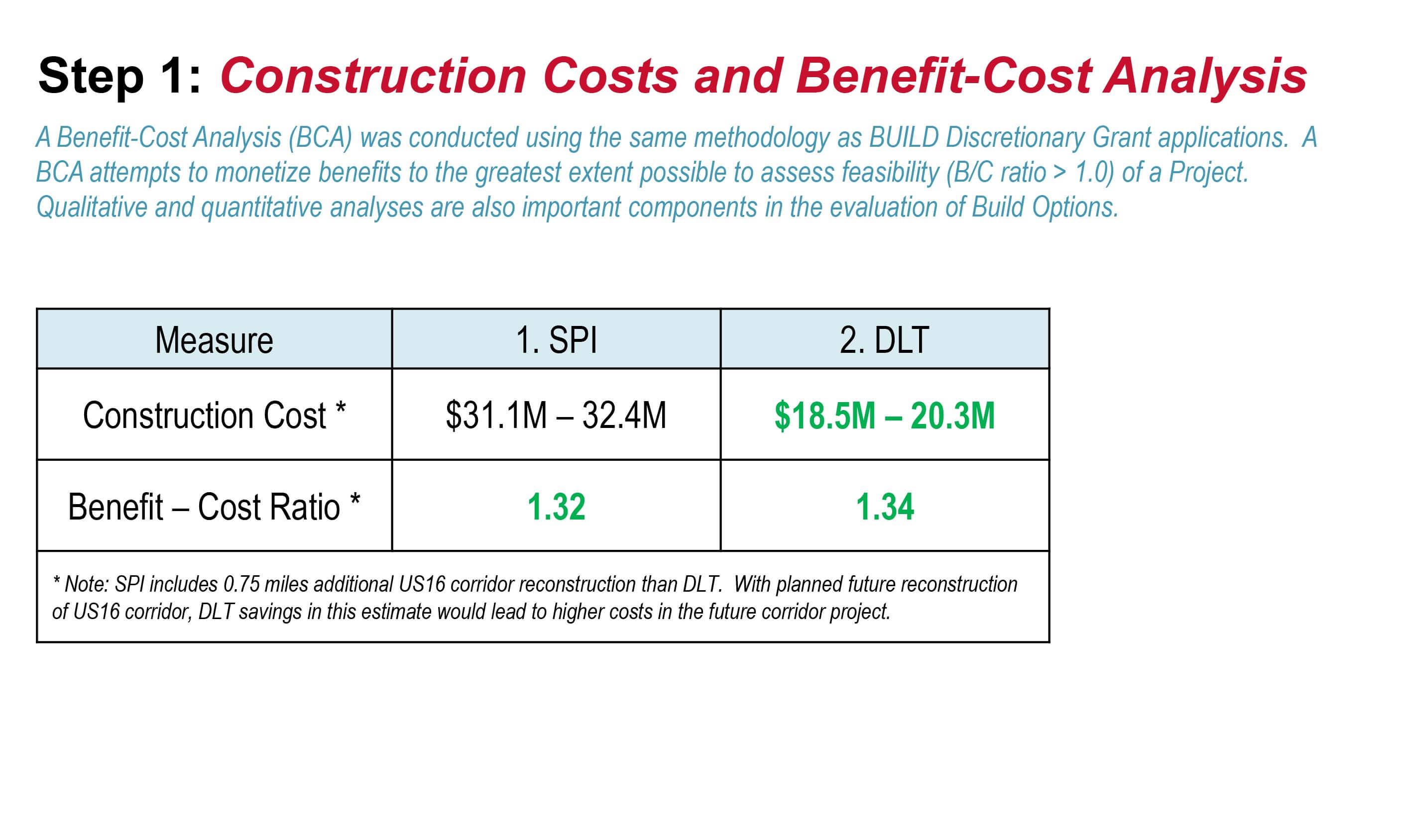
- BCA ratio greater than 1.0 showing that benefits are expected to exceed costs.
SPI Build Options Not Carried Forward Summary Table
DLT Build Options Not Carried Forward Summary Table
US16 Urban Area
Segments A-C
Segment Overview
US16 urban area is applies to the US16 corridor, starting south of the Moon Meadows Drive intersection and extending to the Cathedral Drive/Fairmont Boulevard intersection in Rapid City. Scenarios presented for this segment incorporate the Consultant Recommendation of an SPI at the US16/US16B/Catron Boulevard intersection (planned Fiscal Year 2026 project, identified in 2025-2028 developmental Statewide Transportation Improvement Program (STIP)).
The SDDOT has also identified a US16 corridor project extending north from US16B/Catron Boulevard in their 2025-2028 developmental STIP. A goal of this study is to determine what improvements are needed as part of the planned developmental STIP projects and what reflect a longer-range vision of future projects within the 2050 Planning Horizon.
In addition to the planned US16/US16B/Catron Boulevard intersection planned for Fiscal Year 2026, the SDDOT has also identified a US16 corridor project extending north of US16B/Catron Boulevard. One goal of this study is to identify corridor and intersection improvements:
- Incorporated with the US16/US16B/Catron Boulevard intersection project,
- Incorporated with the programmed US16 corridor project to the north, or
- Are part of a longer-range vision of improvements for future projects within the 2050 Planning Horizon.
Corridor Scenarios – Download PDF
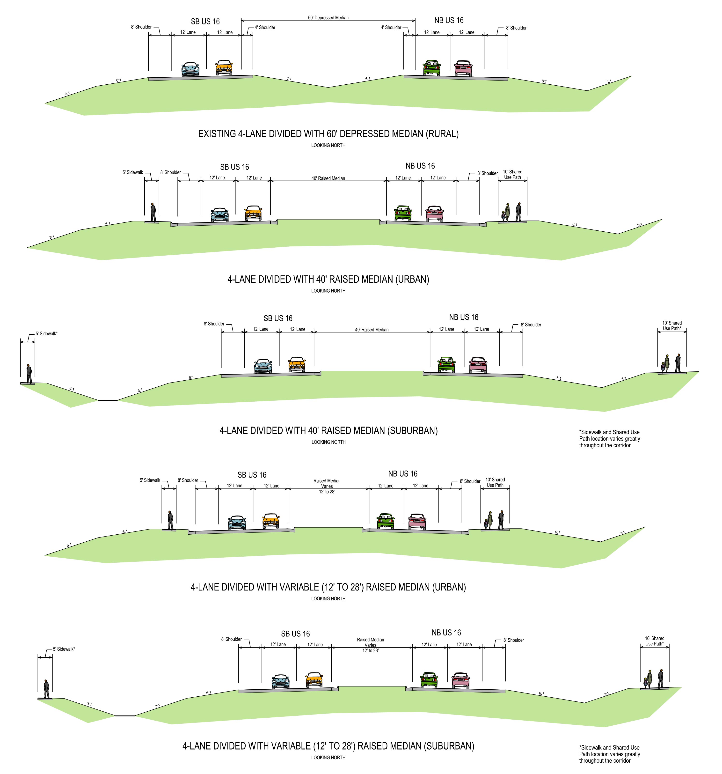
Typical Section Options
- Suburban section throughout corridor
- Urban section at intersections or areas with limited ROW
- 40’ raised median typical
- 12’ to 28’ raised median on grade south of Cathedral Drive
- Shared-use path on east side
- Sidewalk on west side
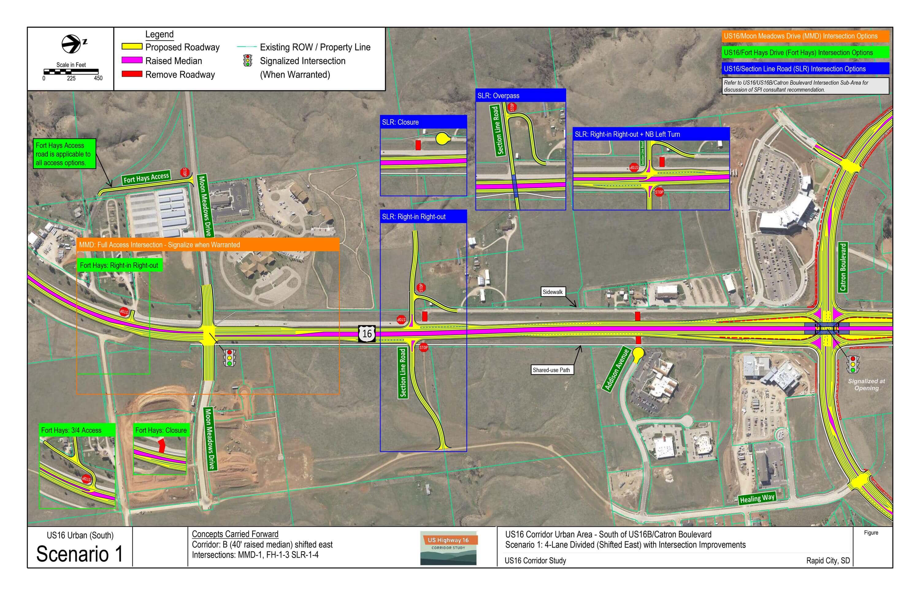
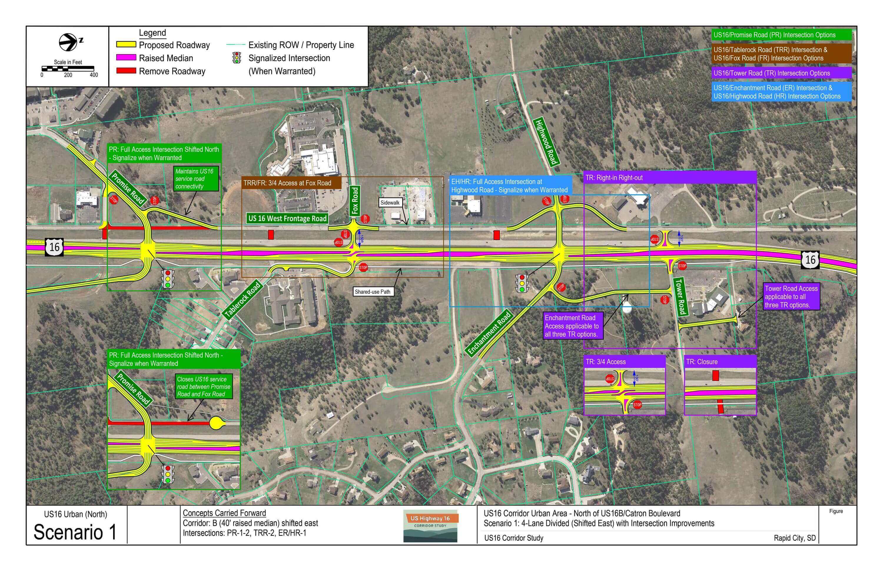
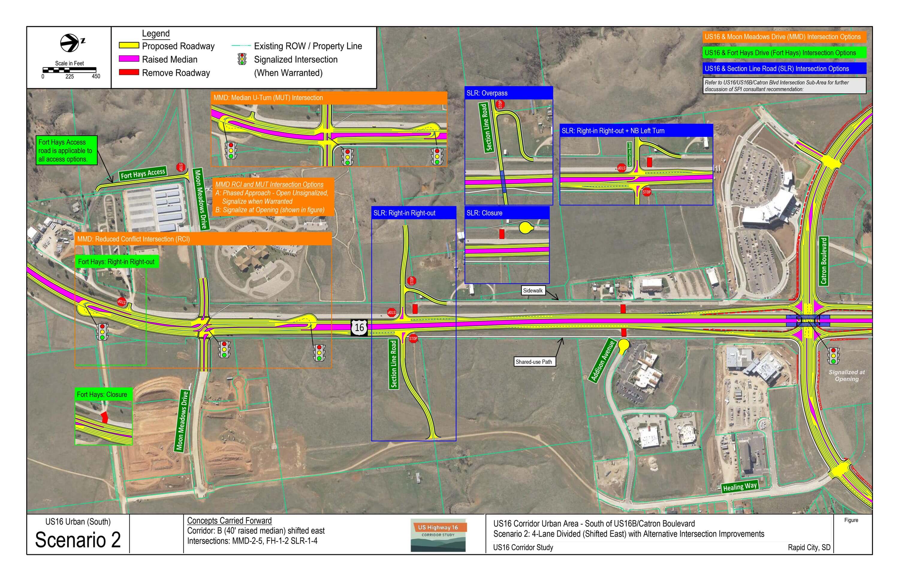
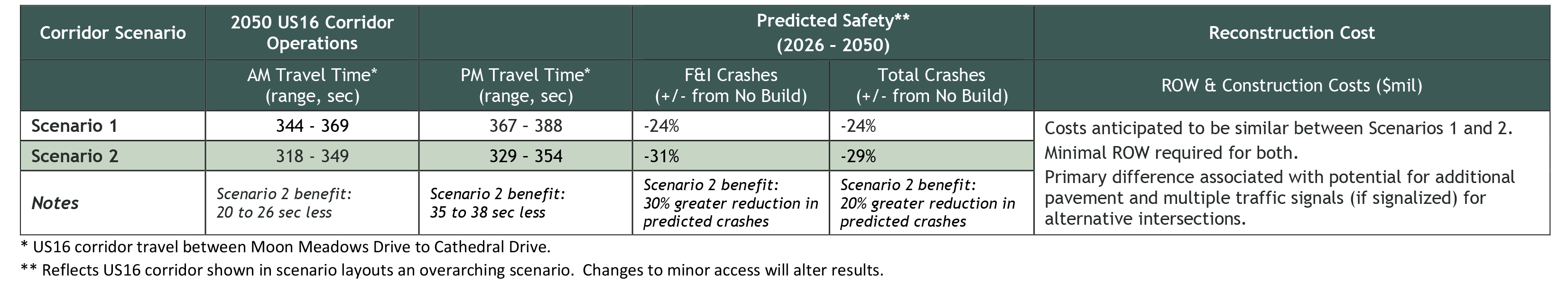
US16 Corridor Scenario 1: 4-Lane Divided (Shifted East) with Intersection Improvements
- Shifted east alignment
- Fort Hays access: ¾, right-in right-out (RIRO), or closure options with rearage connection
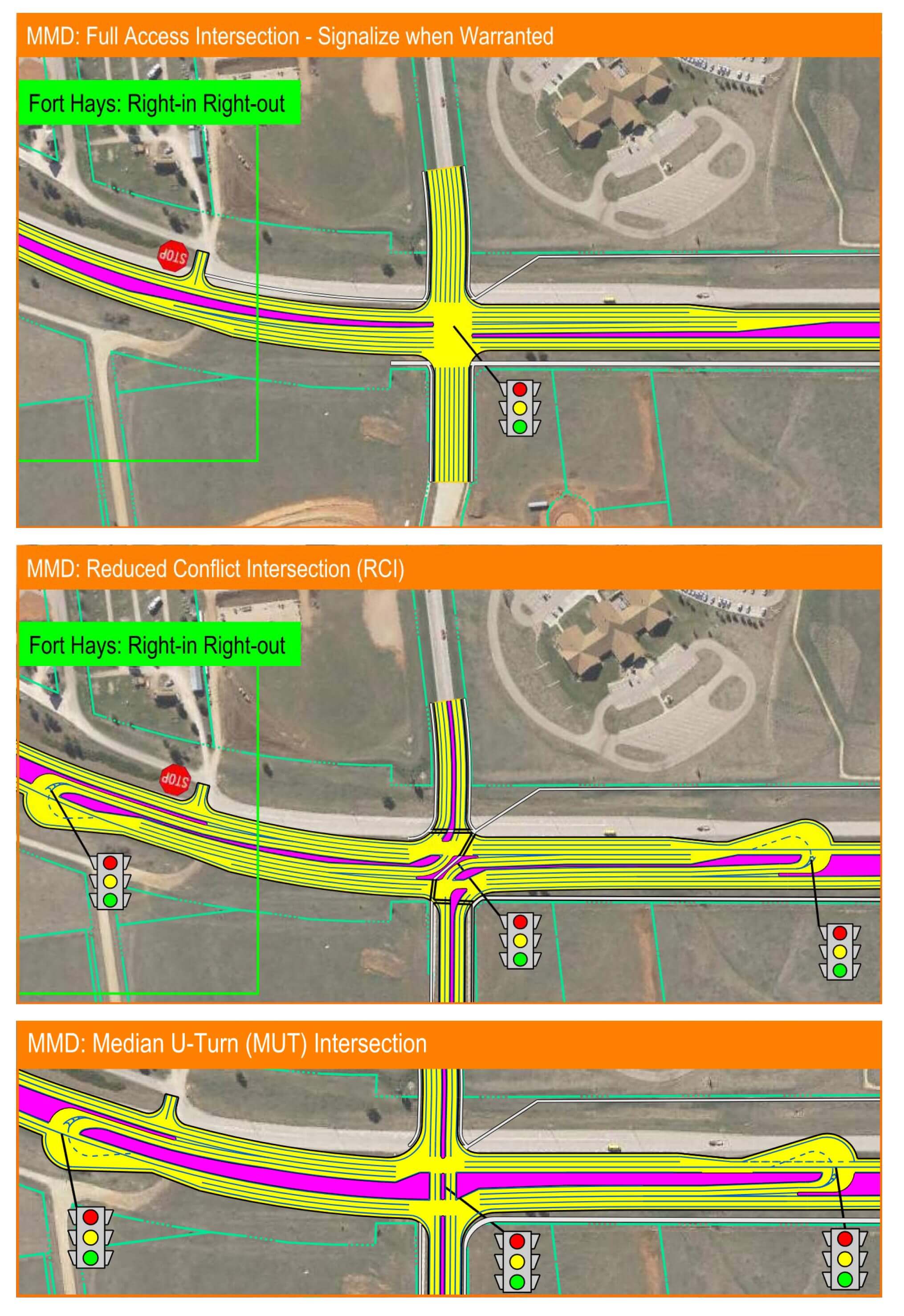
- Moon Meadows Drive intersection: full access (signalize when warranted)
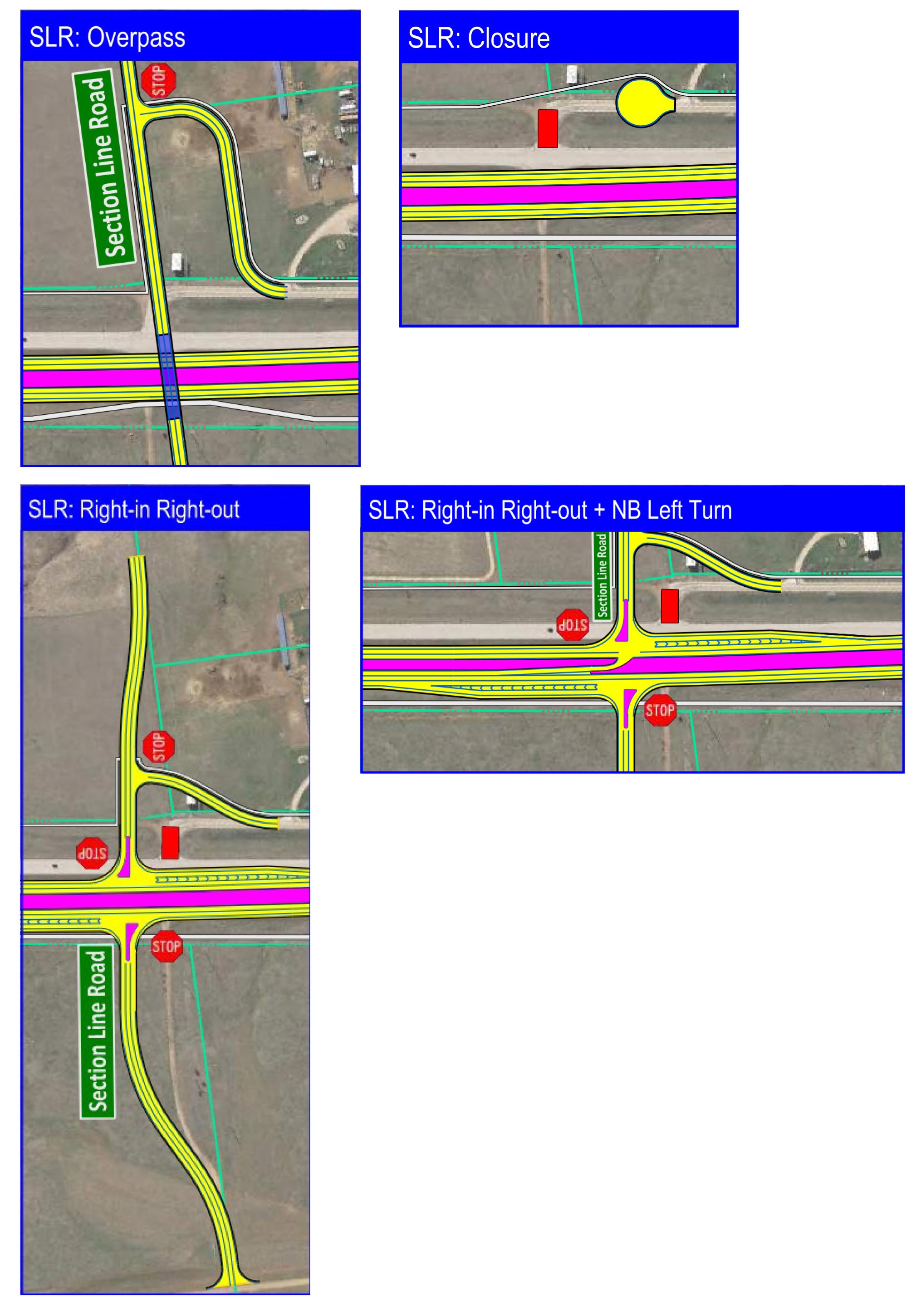
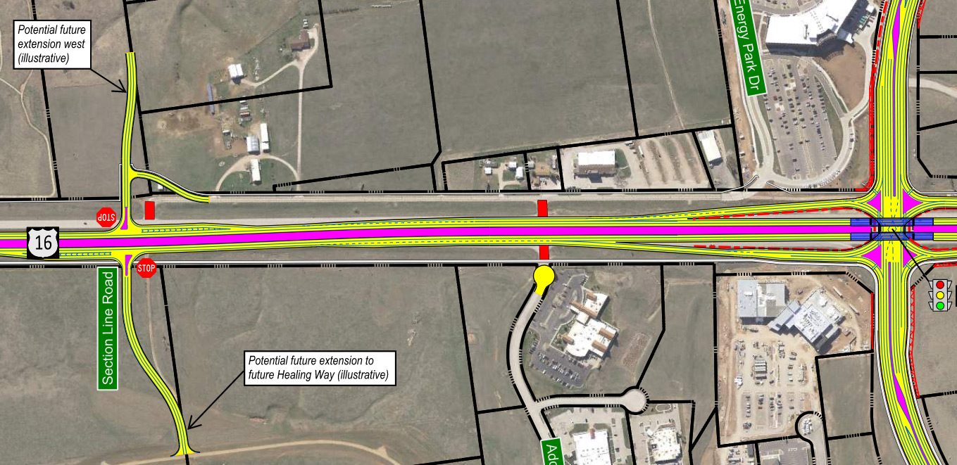
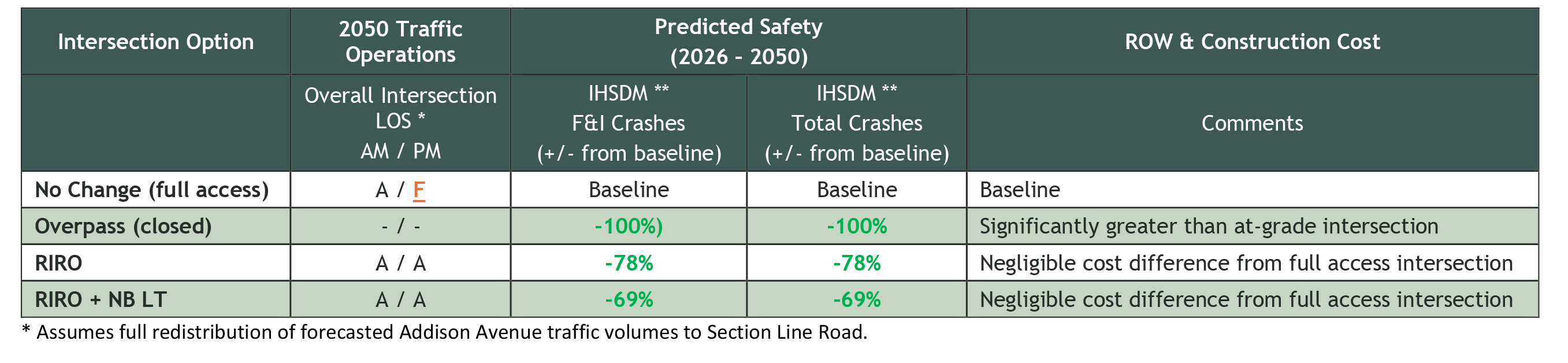
- Section Line Road access: RIRO + NB left turn, RIRO, closure, or overpass options
- Promise Road intersection: full access shifted north (signalize when warranted)
- Tablerock Road access: ¾ access shifted north
- Enchantment Road intersection: full access shifted north to Highwood Road (signalize when warranted)
- Tower Road access: ¾, RIRO, or closure options with connection to Enchantment Road
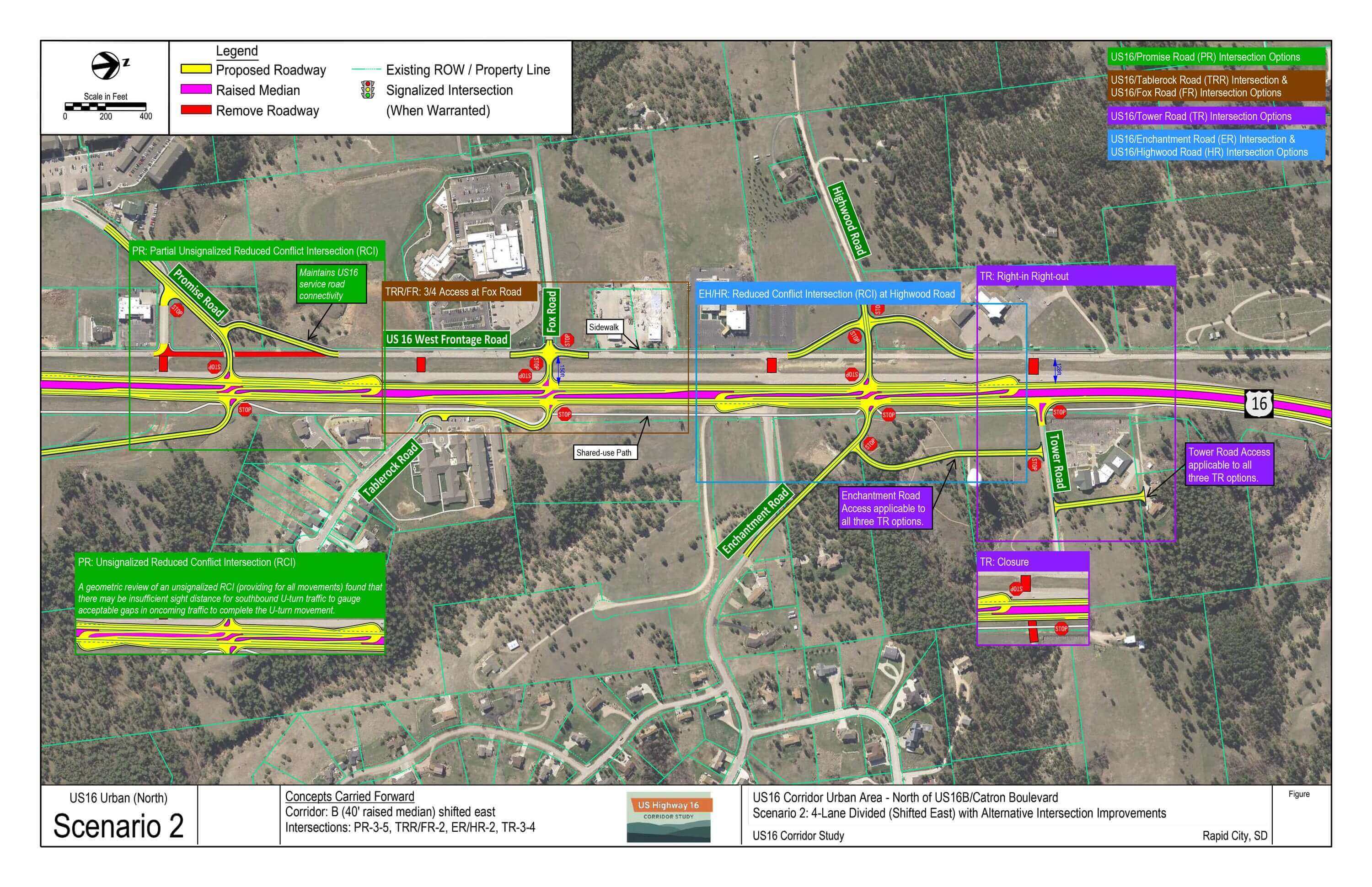
US16 Corridor Scenario 2: 4-Lane Divided (Shifted East) with Alternative Intersection Improvements
- Shifted east alignment
- Fort Hays access: right-in right-out (RIRO) or closure options with rearage connection
- Moon Meadows Drive intersection: full access alternative intersections (signalize when warranted)
- Reduced conflict intersection (RCI)
- Median U-turn (MUT)
- Section Line Road access: RIRO + NB left turn, RIRO, closure, or overpass options
- Promise Road intersection: RCI (signalize when warranted)
- Tablerock Road access: ¾ access shifted north
- Enchantment Road intersection: RCI (signalize when warranted)
- Tower Road access: RIRO or closure options with connection to Enchantment Road
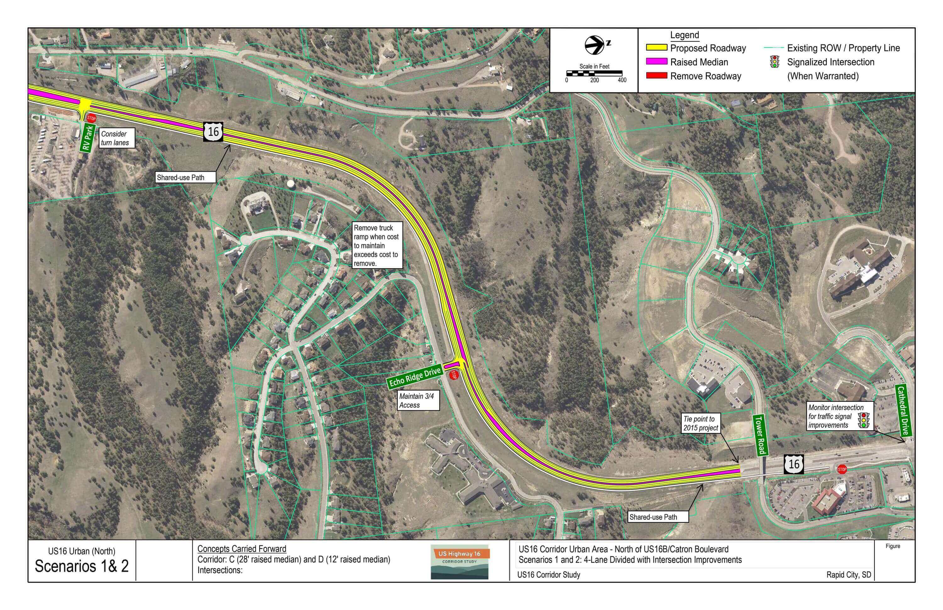
US16 Corridor Scenarios 1 and 2: 4-Lane Divided with Intersection Improvements
- Alignment centered to minimize slope cut/fill impacts
- Echo Ridge access: maintain ¾ access
- Tie into 2015 project south of Cathedral Drive
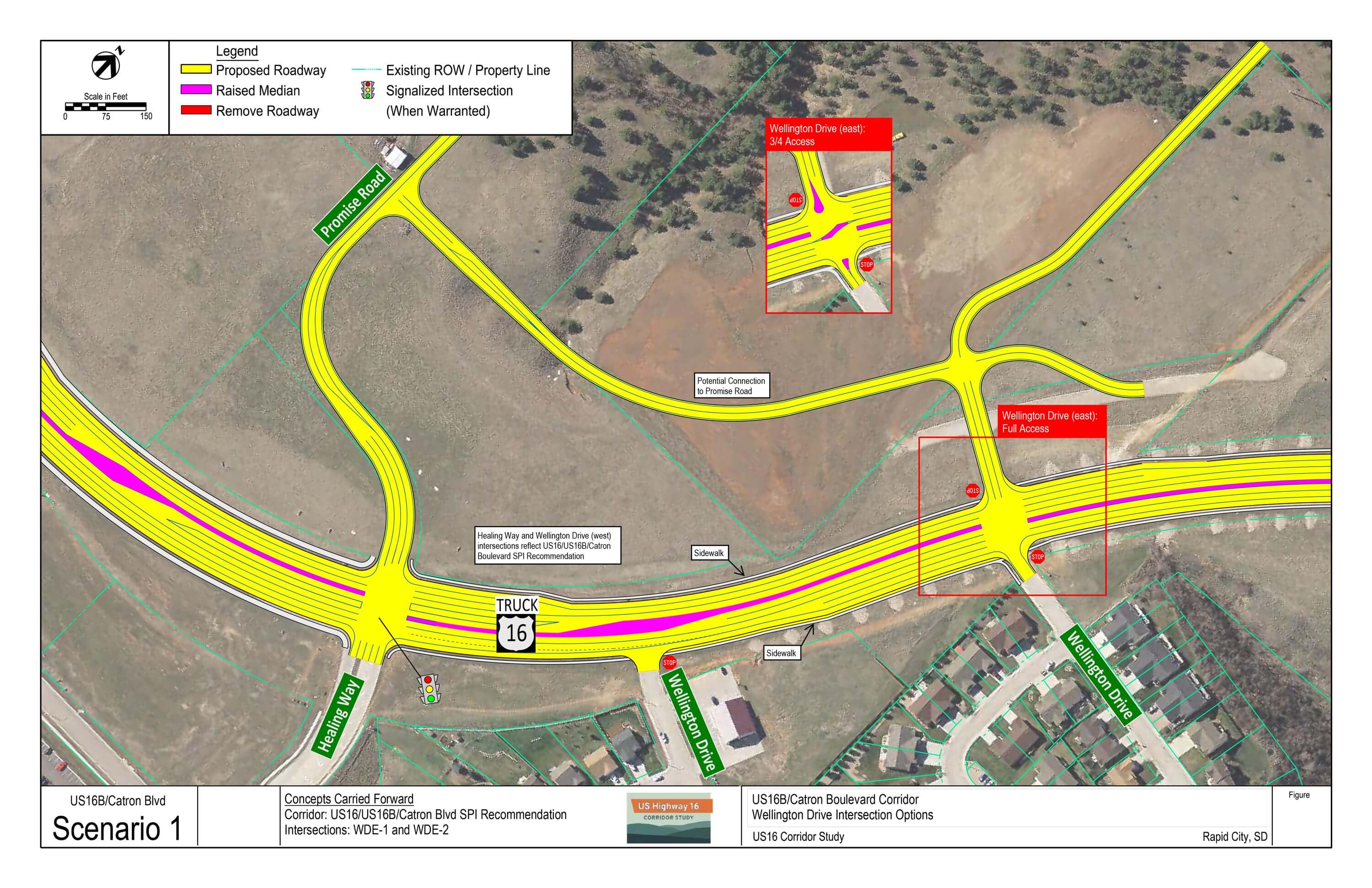
US16/US16B/Catron Boulevard Corridor Scenario 1: Wellington Drive Intersections
- Wellington Drive (west): RIRO as part of SPI layout
- Wellington Drive (east): full or ¾ access options
Major Intersections
This section summarizes evaluation measures, benefits, and drawbacks of each option at the major intersections along the US16 corridor.
US16/Moon Meadows Drive Intersection
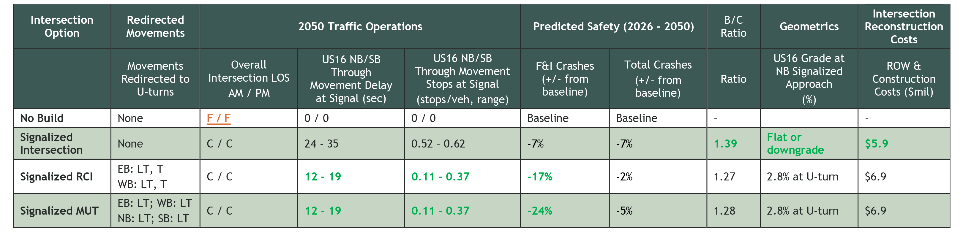
Signalized Intersection Benefits:
- 7% predicted reduction in F&I crashes
- All movements provided at main intersection
- Driver familiarity
- Intersection queue storage areas on flat grade
- Highest B/C ratio (1.39)
Signalized Intersection Drawbacks:
- Greater US16 mainline delay and average number of stops for northbound/southbound through movements at signal
Signalized RCI Benefits:
- 17% predicted reduction in F&I crashes
- Better overall intersection operations compared to signalized intersection
- Lower US16 mainline delay and fewer stops for NB/SB through movements at signals
- Direct US16 left turns to Moon Meadows Drive
- B/C ratio greater than 1 (1.27)
Signalized RCI Drawbacks:
- Out of the way travel for EB/WB Moon Meadows Drive thru and left turn movements
- Higher cost due to additional pavement and signals
- 3% grade through south U-turn
Signalized MUT Benefits:
- 24% predicted reduction in F&I crashes
- Better overall intersection operations compared to signalized intersection
- Lower US16 mainline delay and fewer stops for NB/SB through movements at signals
- EB/WB Moon Meadows Drive thru movements at main intersection
- B/C ratio greater than 1 (1.28)
Signalized MUT Drawbacks:
- Out of the way travel for inbound/outbound Moon Meadows Drive left turn movements (predominant Moon Meadows Drive movements through 2050 Planning Horizon)
- Higher cost due to additional pavement and signals
- 3% grade through south U-turn
Traffic Signal Notes
- Anticipated timeframe traffic signal will be warranted: by 2026
- Candidate intersection for consideration of a traffic signal Advanced Warning System with flashing beacons when signalized.
Is reconstruction required as part of US16/US16B/Catron Boulevard SPI? No, SPI reconstruction can tie into existing US16 alignment prior to Moon Meadows Drive intersection.
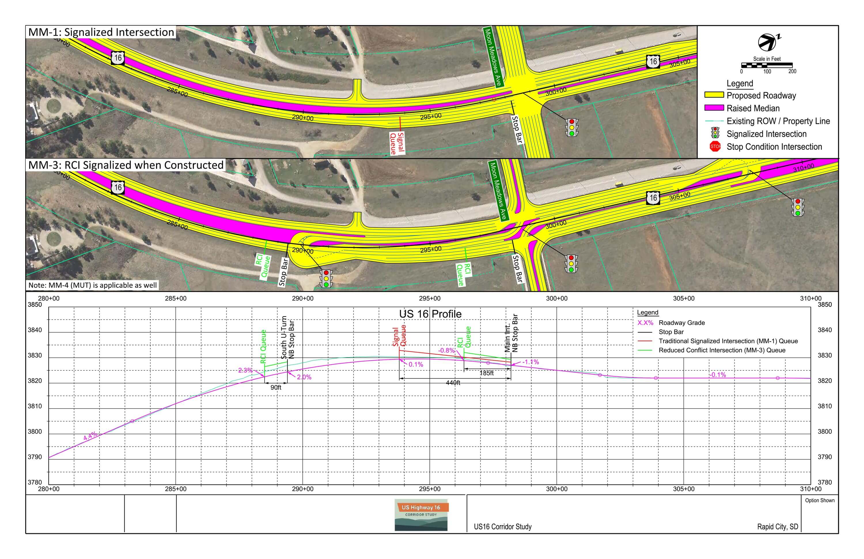
Northbound US16 Corridor Grade Notes
Stakeholders and public comment expressed interest in identifying where traffic will need to stop in relation to the steep grade approaching Moon Meadows Drive if the intersection is signalized. The attached figure shows:
- US16 northbound direction profile to show grade approaching and through the Moon Meadows Drive intersection,
- Where traffic signals would be located for each intersection option, and
- Traffic analysis-measured queue lengths and back of queue points (where the furthest, stopped vehicle would typically be located).
Signalized intersection option finding:
- Main intersection: queue expected to be entirely on flat grade
Signalized RCI/MUT options finding:
- Main intersection: queue expected to be entirely on flat grade.
- South U-turn: queue expected to be on a grade steepening from 2.2@ at the U-turn signal to 2.8%+ grade at the end of the queue.
US16/Section Line Road Intersection
Overpass (closed) Benefits:
- Best ‘intersection’ safety performance
- All traffic routed to major intersections
Overpass (closed) Drawbacks:
- High cost
- May require some out of the way travel for US16 access until local network built out
RIRO Benefits:
- Minimal cost for local network improvements with project
- 78% reduction in predicted crashes compared to full access intersection; greatest safety benefits of at-grade intersection options
RIRO Drawbacks:
- Conflict points on US16, but no cross-traffic angle crash conflicts that have a propensity for higher severity
RIRO + NB Left Turn Benefits:
- Minimal cost for local network improvements with project
- 69% reduction in predicted crashes compared to full access intersection
RIRO + NB Left Turn Drawbacks:
- Includes NB LT cross-traffic angle crash conflict, which is a crash type that has a propensity for higher injury severity
Traffic signal notes:
- Intersection not a candidate for signalization
- Spacing from SPI southbound on-ramp does not provide adequate distance for approaching drivers to safely:
- Perceive and react to a signalized intersection
- Maneuver to the desired lane
- Fully decelerate prior to the back of queue/stopped vehicle point
Southbound US16 left turn notes:
- Spacing from SPI southbound on-ramp does not provide adequate distance for vehicles to enter US16 mainline and weave across through lanes to a left turn lane
- Movement would create undesirable operational and safety impacts on mainline US16 traffic
- SPI and local network improvements address this movement
- All traffic arriving from the north would pass through the SPI or US16B/Healing Way intersection, which were designed to safely and efficiently accommodate high volumes of turning traffic
Northbound US16 left turn notes:
- Northbound left turn has adequate sight distance for further consideration
- Increased level of access vs. degraded corridor safety
Is reconstruction required as part of US16/US16B/Catron Boulevard SPI? Yes, reconstruction is required to locate intersection within a window of opportunity for an unsignalized access point. Window of opportunity accounts for driver perception and reaction time after entering US16 mainline from the proposed SPI on-ramp, maneuver distance to the appropriate lane, and deceleration to make a right turn.
Consultant Recommendation:
The consultant recommendation is to construct RIRO access, shifted south, with SPI project. This recommendation provides the following operational and safety benefits:
- Incorporates turn restrictions
- Prohibits high-severity left turn angle conflicts
- Provides adequate spacing from ramps
- Shifts US16 to new alignment to increase spacing from US16 service road
- Provides framework for local network/development connectivity
Long-range recommendation: construct overpass, when...
- Traffic volumes reach a point to where they are creating safety and/or operational issues at the intersection,
- Local roadway connectivity is built-out and/or Section Line Road is extended to SD79, or
- An interchange is to be constructed at US16/Moon Meadows Drive.
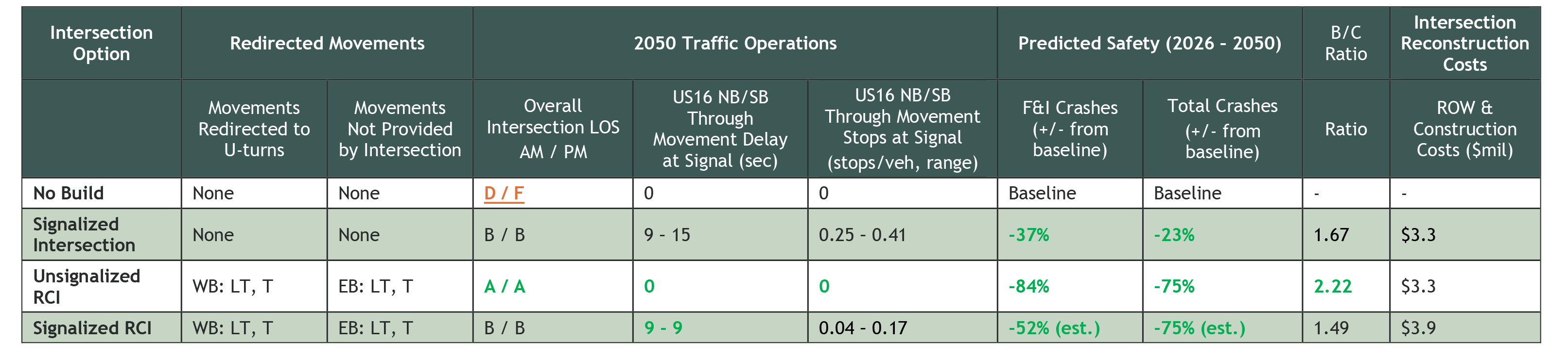
US16/Promise Road Intersection
Signalized Intersection Benefits:
- 37% predicted reduction in F&I crashes
- All movements provided at main intersection
- Driver familiarity
- Provides greatest separation between SPI ramps and first conflict point
- No intersection functional area overlap with SPI ramps
- B/C ratio greater than 1 (1.67)
Signalized Intersection Drawbacks:
- Greater US16 mainline delay and average number of stops for NB/SB US16 through movements at signal
Unsignalized RCI Benefits:
- 84% predicted reduction in F&I crashes
- Best overall intersection traffic operations (LOS A)
- Zero US16 mainline delay due to unsignalized (free) movements
- Highest B/C ratio (2.22)
Unsignalized RCI Drawbacks:
- Due to SB U-turn sight distance constraints with NB SPI entrance ramp, southern U-turn not incorporated in intersection option
Signalized RCI Benefits:
- 52% (estimated) predicted reduction in F&I crashes
- Slightly less US16 mainline delay than traditional signalized intersection
- B/C ratio greater than 1 (1.49)
Signalized RCI Drawbacks:
- Higher cost due to additional pavement and signals
- Due to the signalized southern U-turn intersection functional area overlap into the NB SPI entrance ramp, southern U-turn not incorporated in intersection option
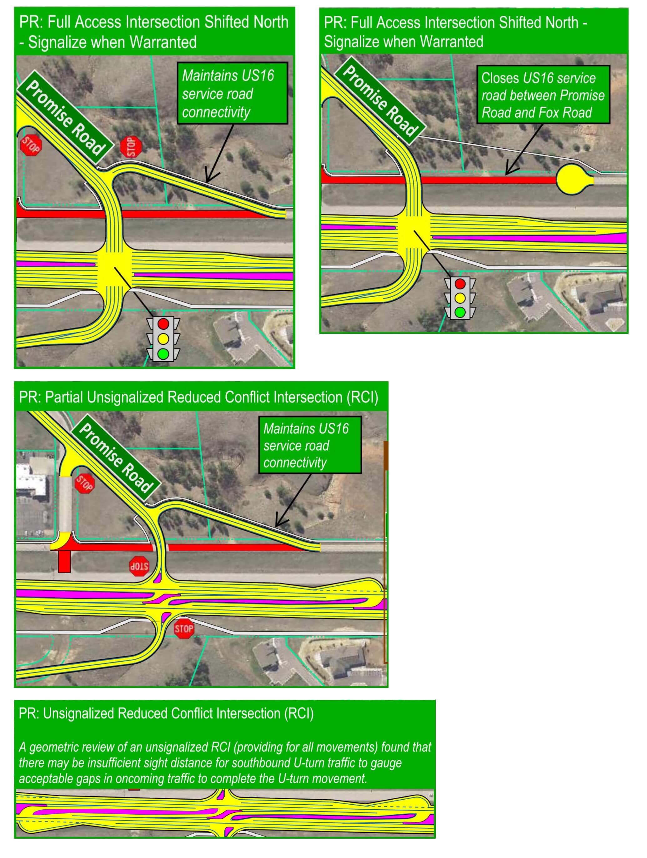
Intersection location notes:
- Intersection needs to shift northward to provide adequate separation from northbound SPI on-ramp.
- Location shown reflects a balance of US16 design speed, terrain considerations, and minimizing impacts to existing development.
- Proposed location provides adequate distance for northbound US16 drivers approaching Promise Road to safely:
- Perceive and react to a signalized intersection
- Maneuver to the desired lane
- Fully decelerate prior to the back of queue/stopped vehicle point
Traffic signal notes:
- Anticipated timeframe traffic signal will be warranted: by 2030
Is reconstruction required as part of US16/US16B/Catron Boulevard SPI? Yes, reconstruction is required to relocate main intersection further north to provide full signalized (when warranted) intersection functional area for approaching traffic.
RCI spacing notes:
- Southbound U-turn omitted from RCI layouts due to:
- Limited sight distance for U-turn traffic with approaching SPI on-ramp traffic, and
- Limited distance for northbound SPI on-ramp traffic to safety merge onto US16 mainline and complete desired maneuvers prior to reaching slow/stopped vehicles at a signalized southern U-turn intersection.
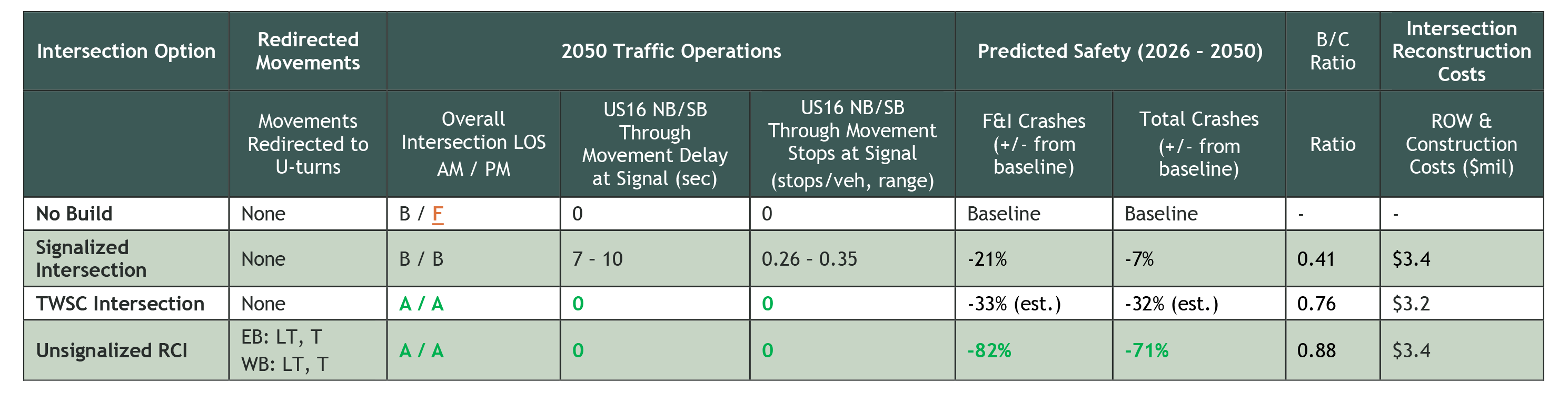
US16/Enchantment Road Intersection
Signalized Intersection Benefits:
- 21% predicted reduction in F&I crashes
- Improves traffic operations when volumes exhibit a need for signalization
- Driver familiarity
- Easy transition from TWSC to signalized intersection
Signalized Intersection Drawbacks:
- Greater US16 mainline delay and average number of stops for NB/SB US16 through movements at signal
- Signal not shown to be warranted until end of 2050 Planning Horizon
TWSC Intersection Benefits:
- 33% (estimated) predicted reduction in F&I crashes
- TWSC may suffice for several years before signal is warranted
- Driver familiarity
- Zero US16 mainline delay due to unsignalized (free) movements
- Easy conversion to signalized intersection
TWSC Intersection Drawbacks:
- Median must be wide enough for 2-stage crossing. Single-stage crossing results in overall intersection LOS F
- LOF F delay on side streets during 2050 peak hours
Unsignalized RCI Benefits:
- 82% predicted reduction in F&I crashes
- Best overall intersection traffic operations (LOS A)
- Zero US16 mainline delay due to unsignalized (free) movements
- Convert to signalized RCI when warranted
- Highest B-C ratio (0.88)
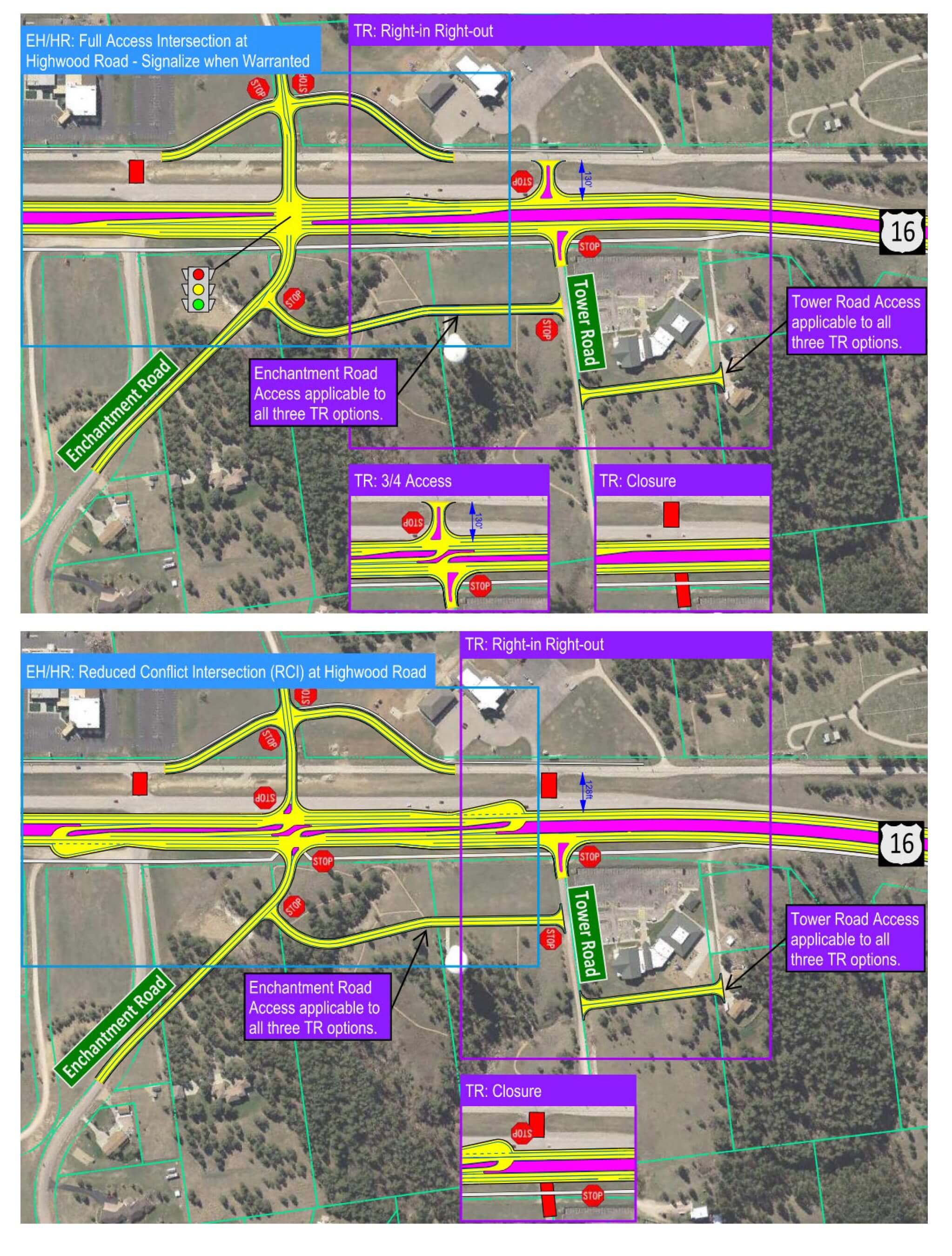
Intersection location notes:
- Intersection shifted north to provide:
- Connectivity with Highwood Road
- Provide 250-foot spacing between US16 service road and US16 mainline
- Local network connectivity encouraged on east side, providing for the following safety benefits:
- Connect development to a major, full access intersection (Enchantment Road)
- Restrict or eliminate minor access turn movements
Traffic signal notes:
- Anticipated timeframe traffic signal will be warranted: beyond 2040 (highly dependent on development)
Is reconstruction required as part of US16/US16B/Catron Boulevard SPI? No, the US16 shifted east alignment through Promise Road and Tablerock Road can transition back to the existing Enchantment Road intersection at the desired design speed. Traffic analysis shows significant modifications to traffic control not anticipated to be needed in the near-term (need is highly dependent on development).
US16 Corridor
This section summarizes corridor-wide evaluation measures and considerations reflected in the corridor scenarios.
US16 alignment notes:
Shifted east alignment (within existing ROW) best met goals for the urban US16 corridor by providing the following benefits:
- Provides greater separation with US16 service road
- Improved constructability with work area being separate from existing lanes
- Maintains traffic on existing roadway during construction of new lanes off alignment
- Fewer utility impacts – existing utilities primarily located on west side
US16 service road notes:
Benefits to maintaining US16 service road and incorporating improved connectivity in corridor scenarios include:
- Maintains existing access to parcels and minimizes costs associated with relocating existing parcel access to other roadways.
- Minimizes construction (cost) of new frontage/local network roadways to replace gaps if service road removed.
- Maintains local network connectivity to the benefit of US16 corridor operations and safety.
- Gaps in service road connectivity would require short trips on US16, which in turn increases US16 turning movements at the expense of intersection operations and safety.
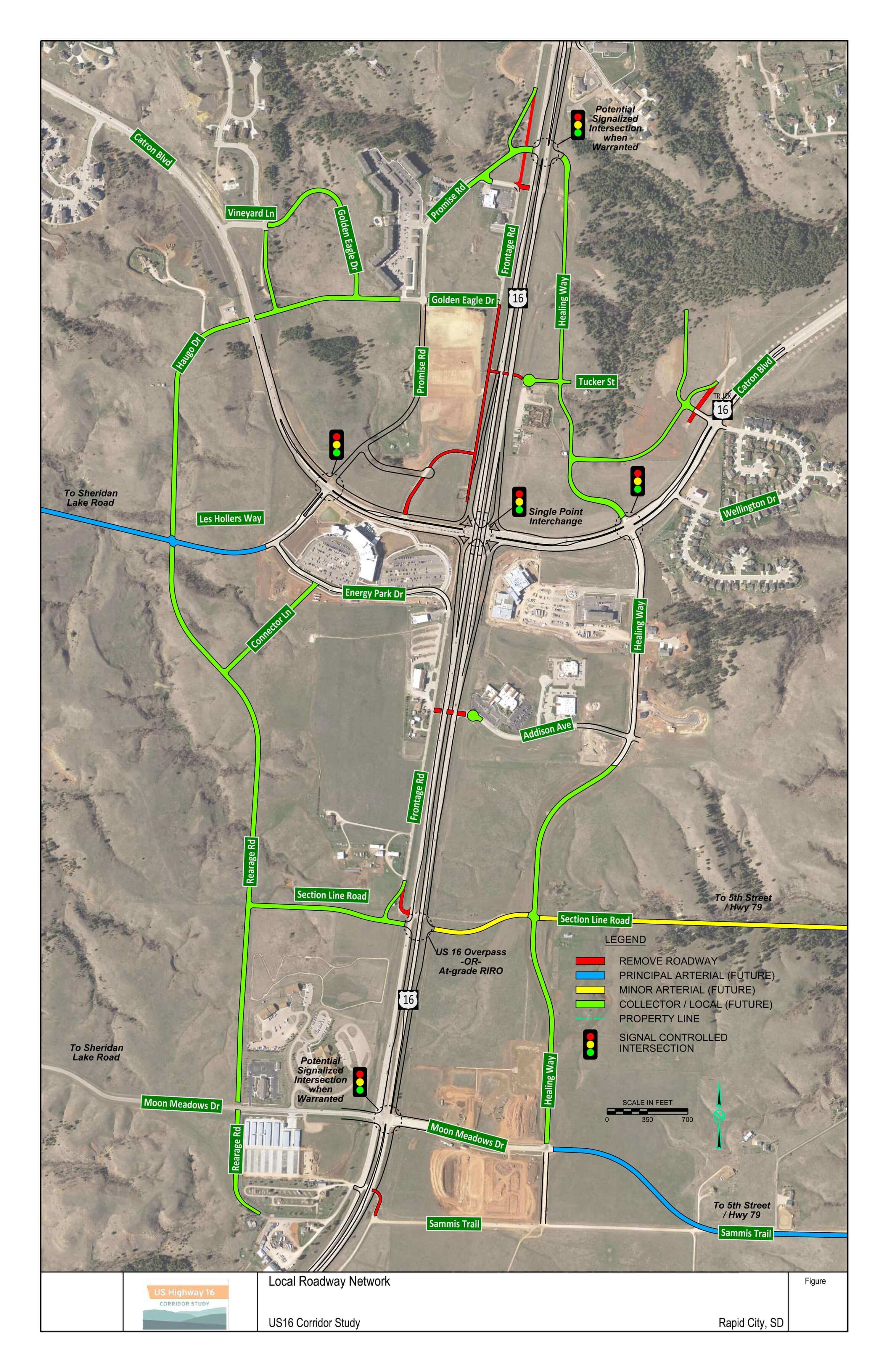
Local Roadway Network
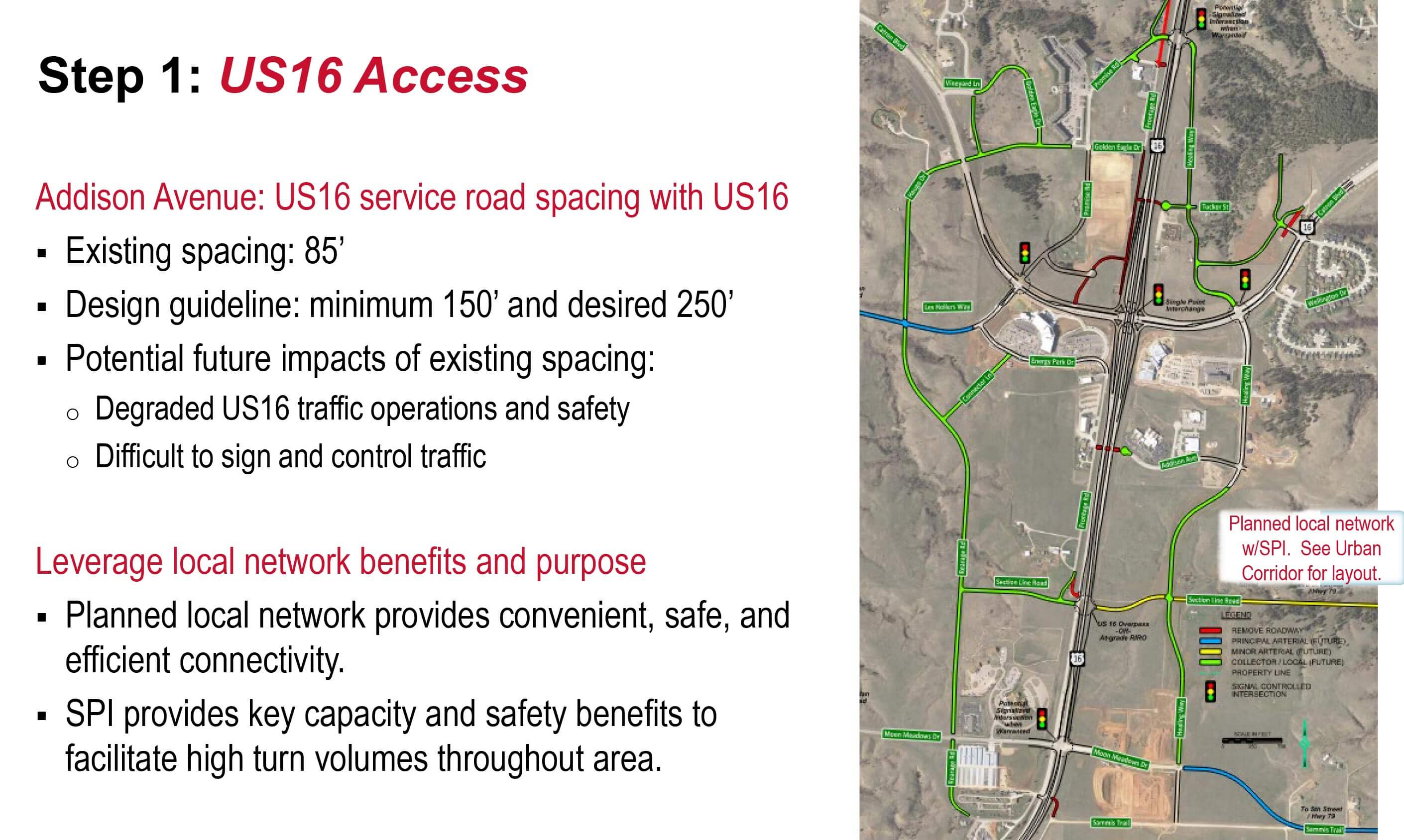
The US16 Urban Area Local Network figure builds upon the Rapid City Major Streets Plan to incorporate the Consultant Recommendation of an SPI at US16/US16B/Catron Boulevard. This figure represents a long-range access and local network connectivity plan for the US16 urban area surrounding the US16/US16B/Catron Boulevard intersection.
Relationship of US16/US16B/Catron Boulevard Intersection Consultant Recommendations with US16 Urban Area Scenarios – Download PDF
Single Point Interchange (SPI):
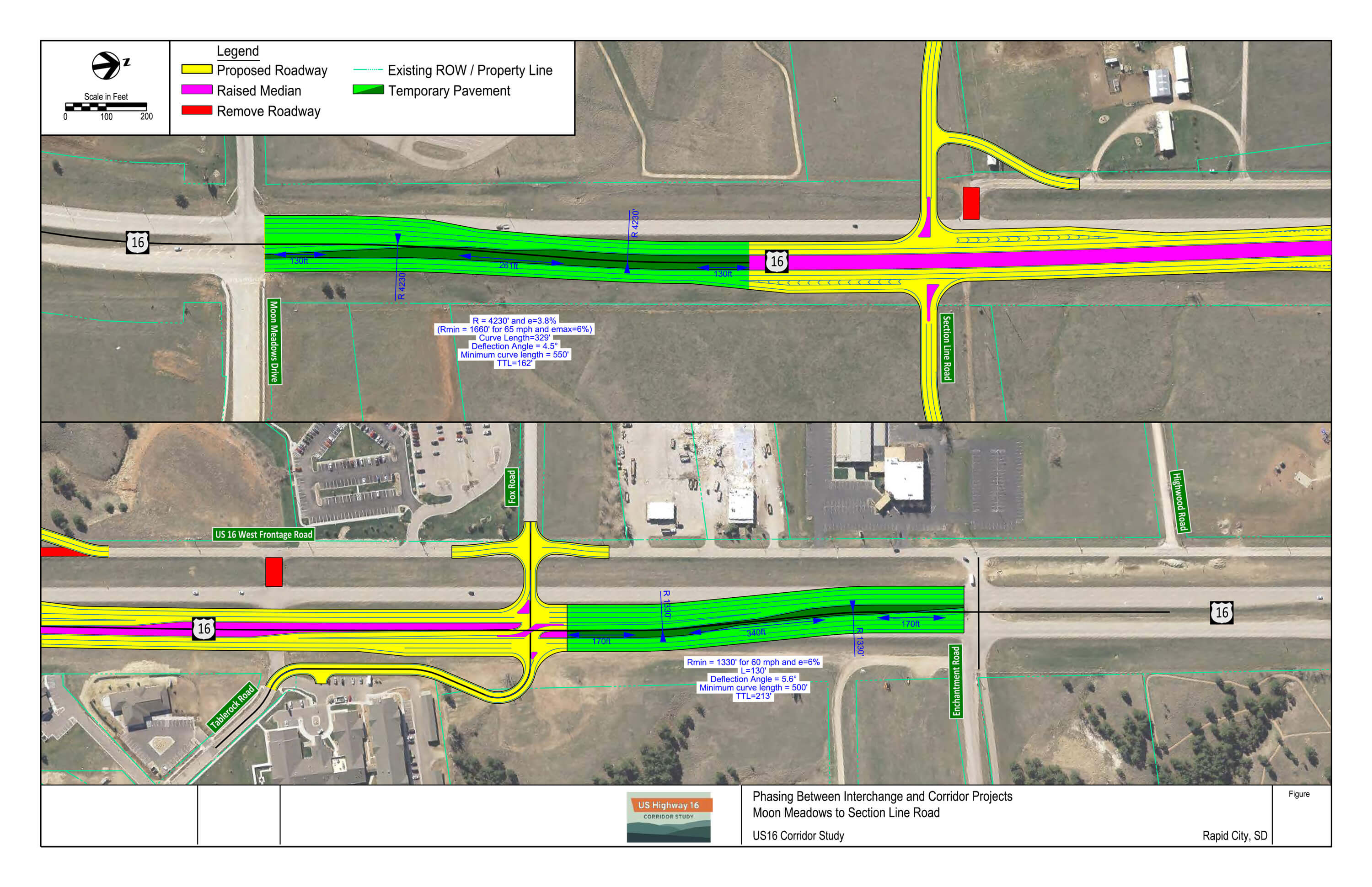
Layout reflecting Consultant Recommendations and considerations for the planned US16/US16B/Catron Boulevard intersection project. See the US16/US16B/Catron Boulevard intersection sub-area section for more discussion on the Consultant Recommendation of SPI 1.1a.
Potential transition sections between SPI project limits and existing US16 roadway.
US16/Neck Yoke Road
Segment D
Segment Overview
Purpose and Need
The project team shared the preliminary purpose and need statements at the previous public meetings and solicited your input. Preliminary build options for each intersection have been developed to satisfy the identified project needs.
Purpose:
To improve safety and access management in the area of Neck Yoke Road.
Needs:
High crash rate. This intersection has a weighted crash rate that is in the top 5 along US 16. The severity of crashes includes one fatality and two incapacitating crashes in the past five years. It experiences a diverse range of vehicle types and driver familiarity as it provides access to several tourist destinations and also services rural residences and a school.
Multiple access points. Neck Yoke Road is the southern-most access in a series of four access points to US 16. An increased number of access point introduces opportunities for additional conflict points between vehicles and can lead to an increase in crashes, depending on the traffic control and geometrics of the access points.
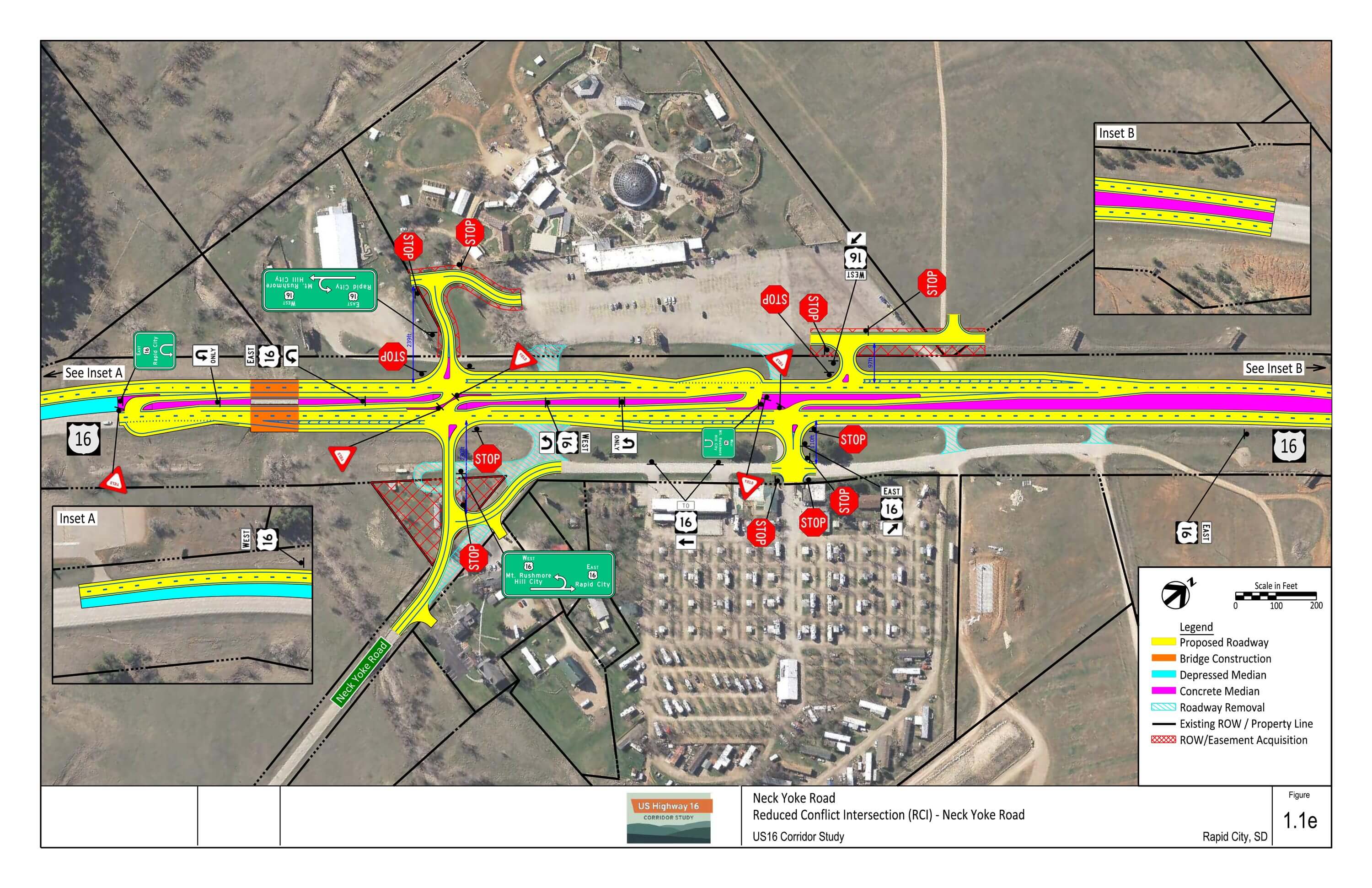
Finalist Intersection Build Options – Download PDF
Layouts of all options considered can be found at the bottom of this page.
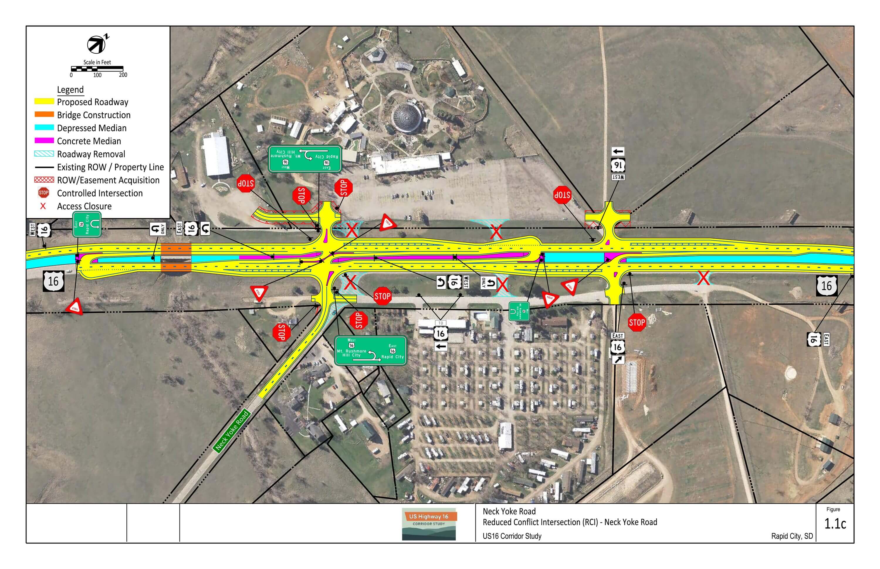
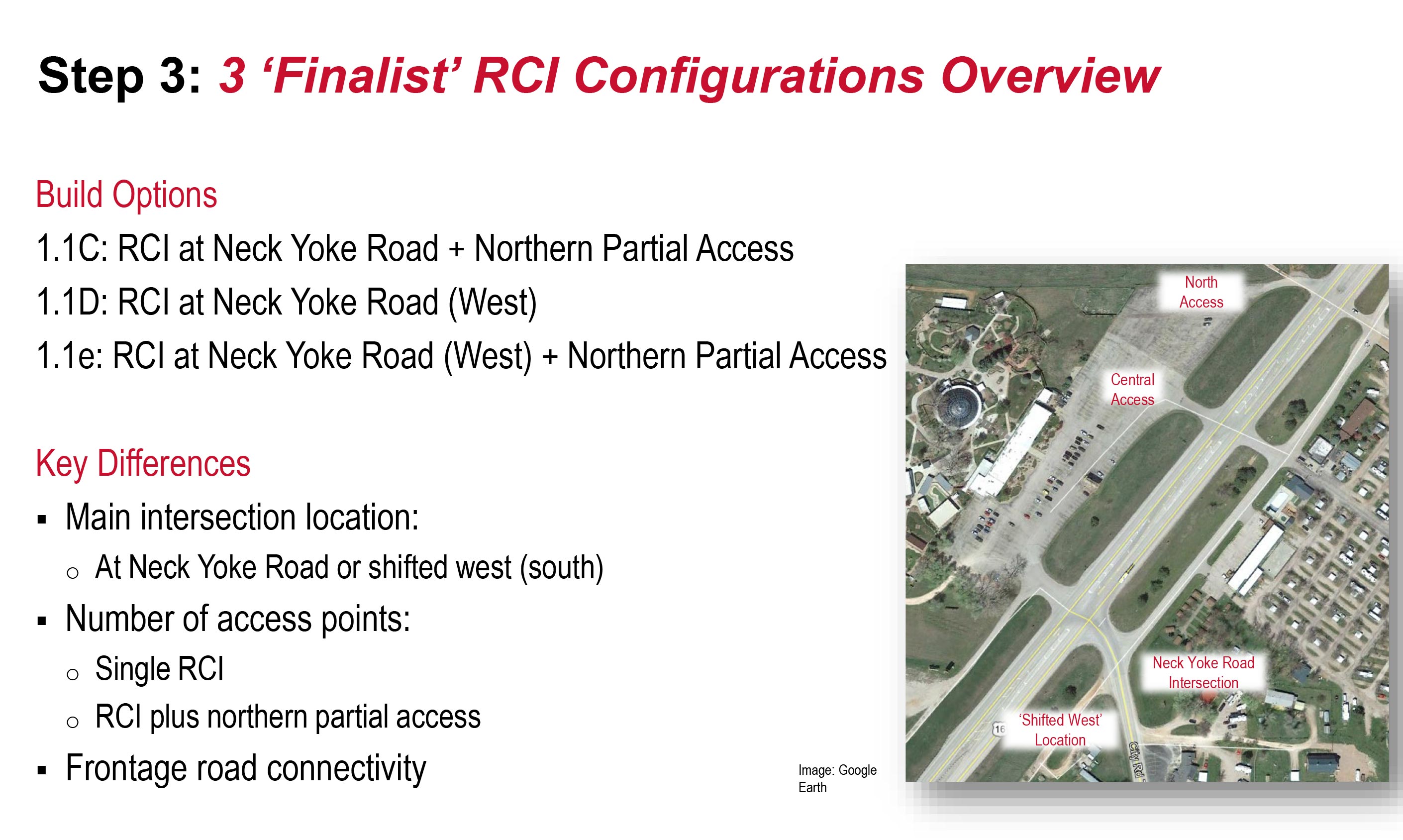
1.1c: RCI at Neck Yoke Road plus Northern Partial Access
- Similar layout to 1.1b
- Lone difference is omission of EB to WB U-turn at the northern partial access to reduce number of conflict points
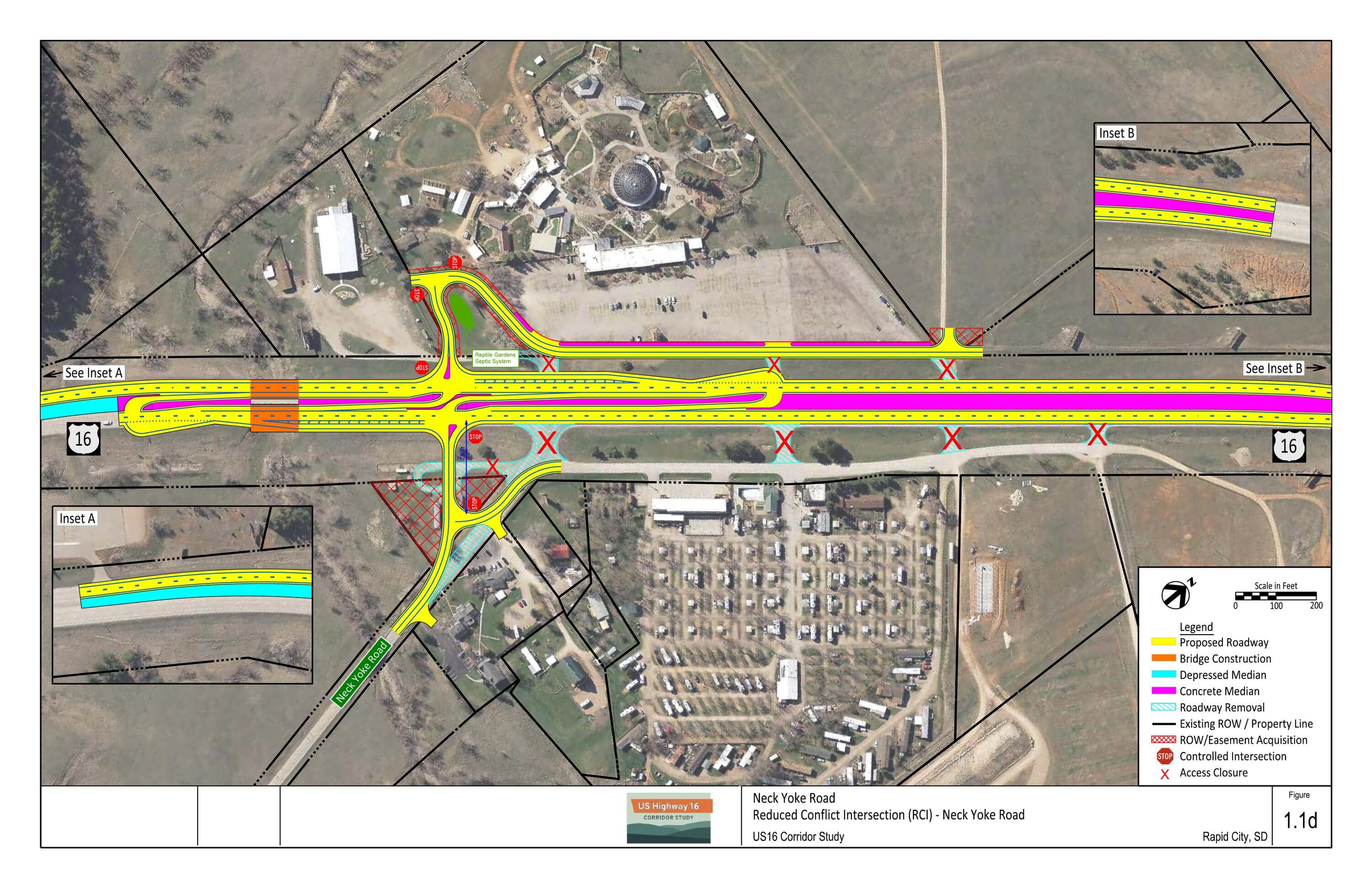
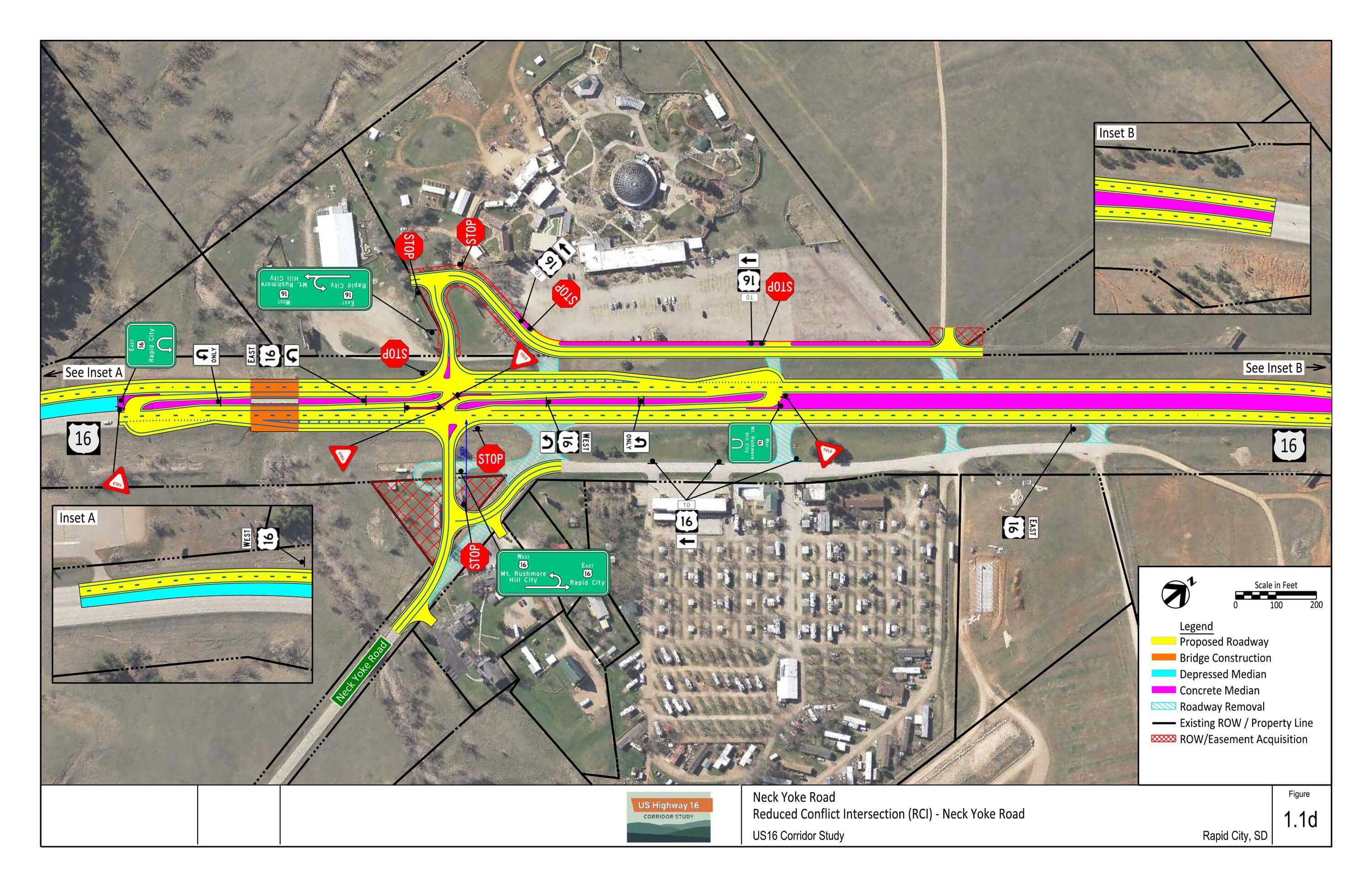
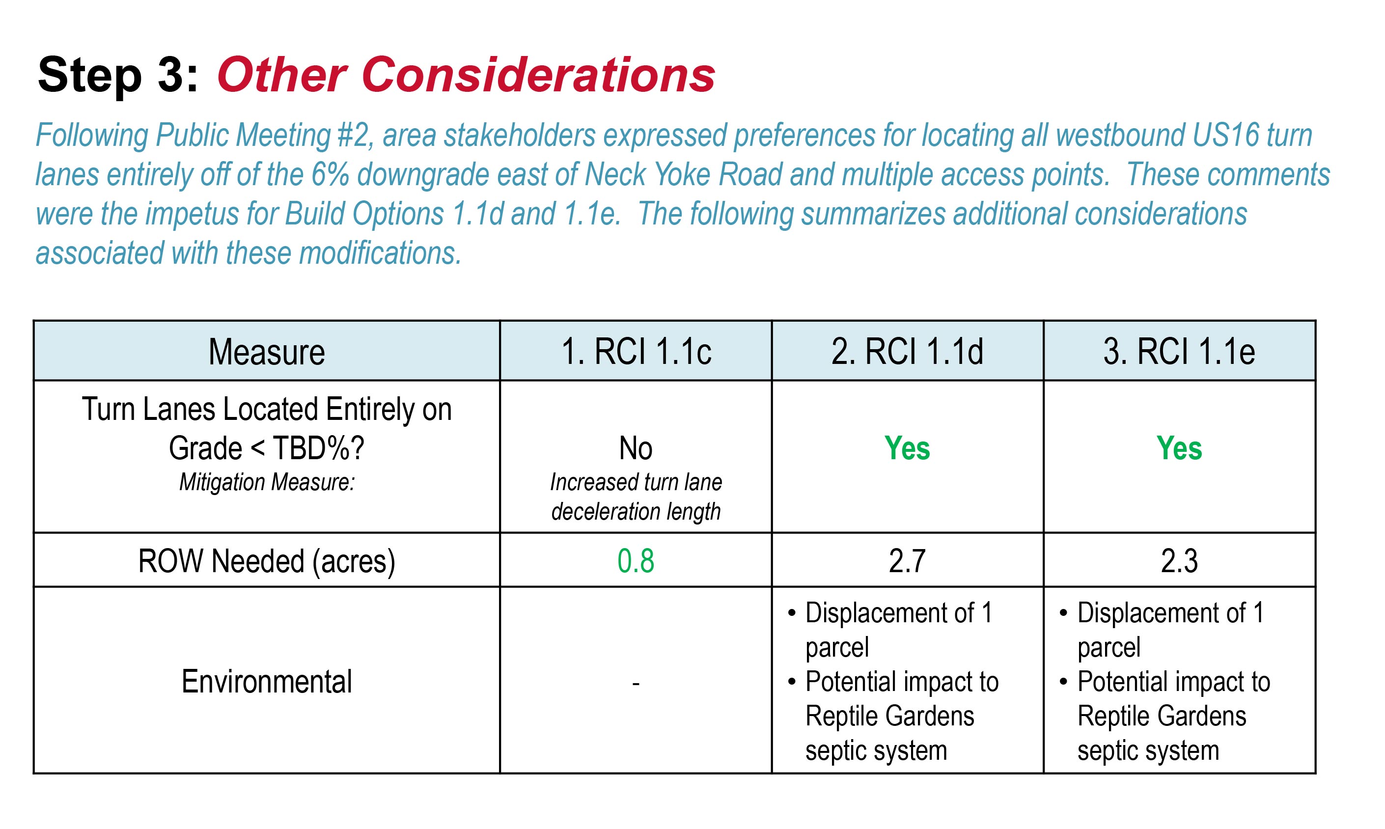
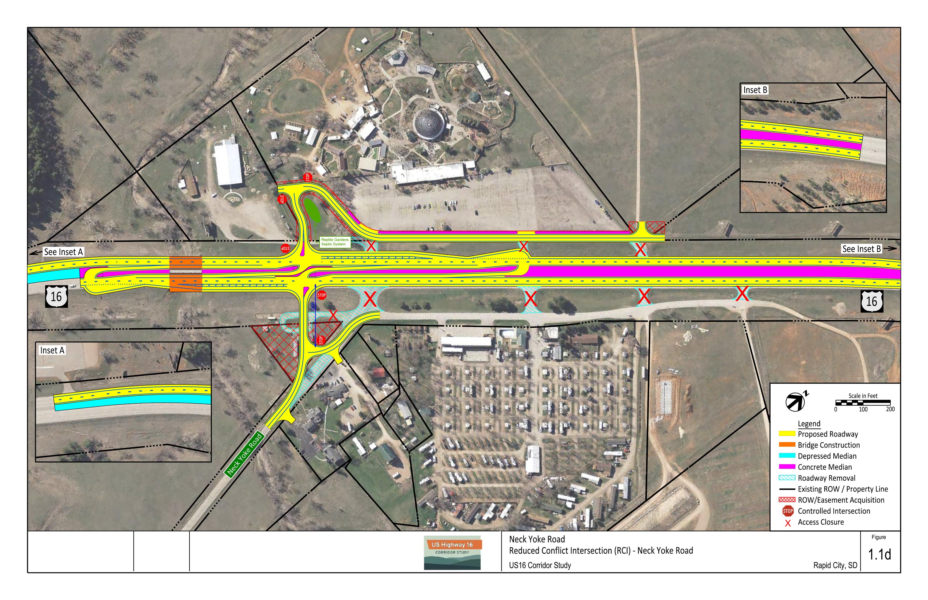
1.1d: RCI at Neck Yoke Road (West)
- RCI at Neck Yoke Road intersection, shifted 250 feet west
- All area access points consolidated to main RCI
- New frontage road on west side of US16
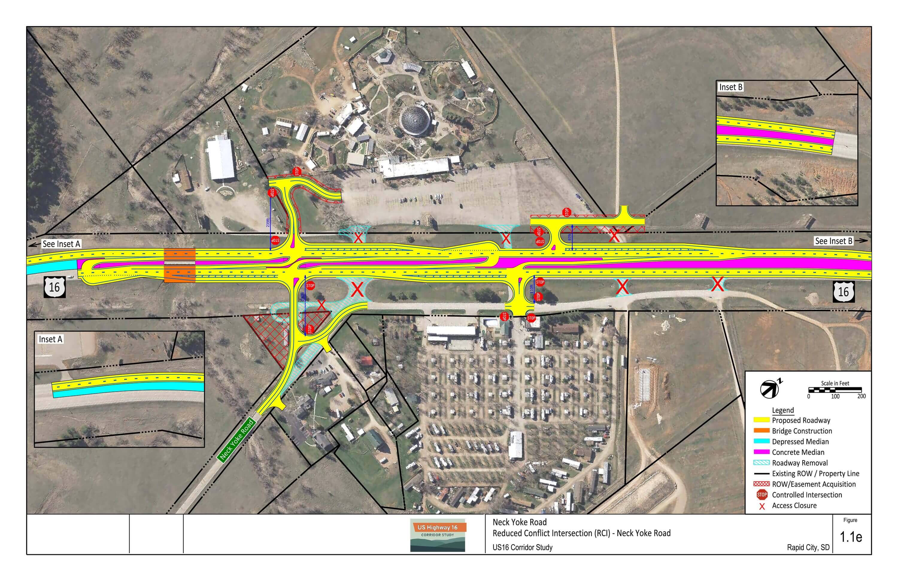
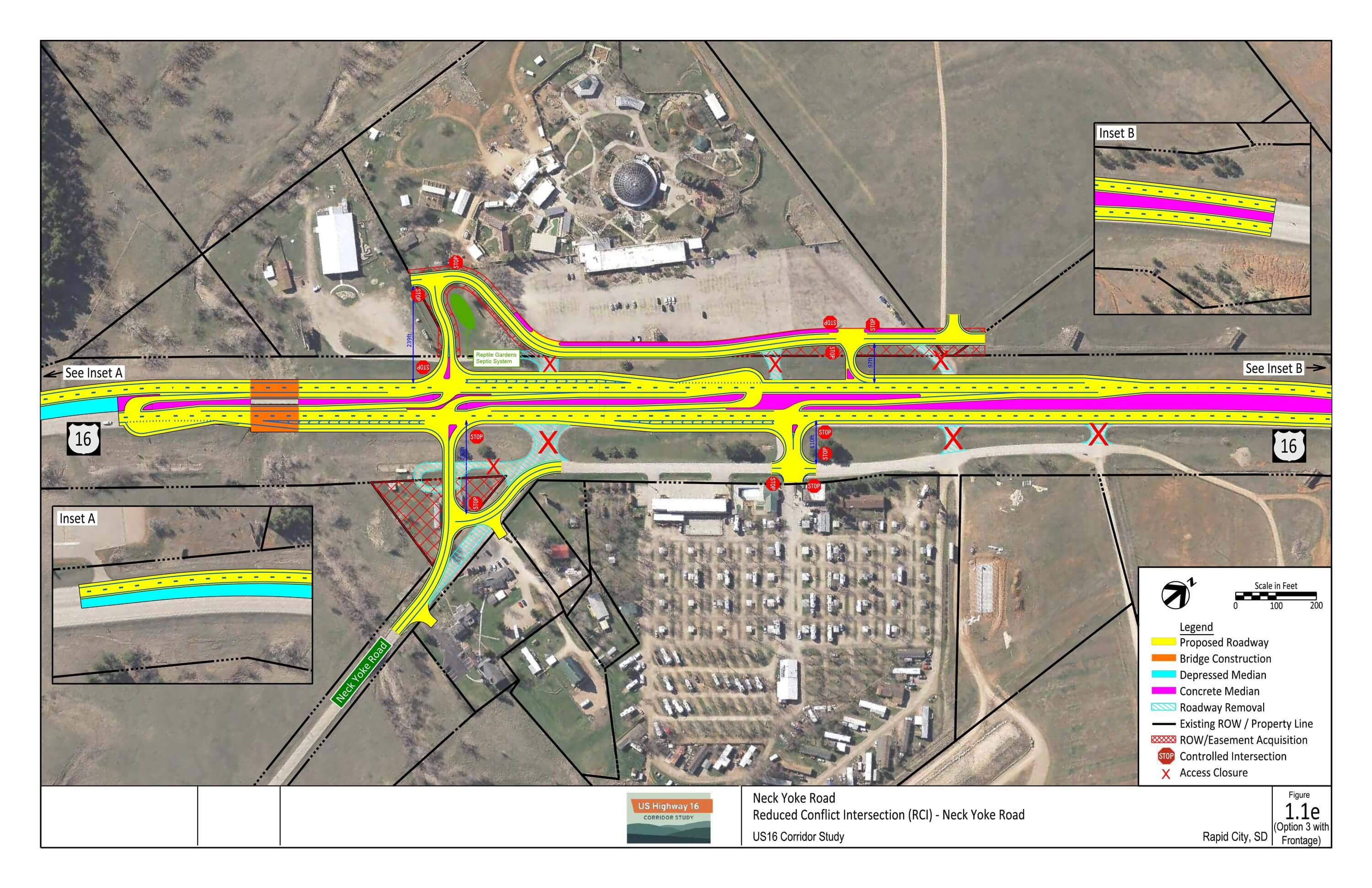
1.1e: RCI at Neck Yoke Road (West) plus Central Partial Access (2 options)
- Similar layout to 1.1e
- Adds partial access at central Reptile Gardens/US16 service road intersection
- Option with and without frontage road on west side of US16
Conceptual Signing Plans – Download PDF
1.1c: RCI at Neck Yoke Road plus Northern Partial Access
1.1d: RCI at Neck Yoke Road (West)
1.1e: RCI at Neck Yoke Road (West) plus Central Partial Access (Option 1)
1.1e: RCI at Neck Yoke Road (West) plus Central Partial Access (Option 2)

Environmental Considerations
US16/Neck Yoke Road Intersection
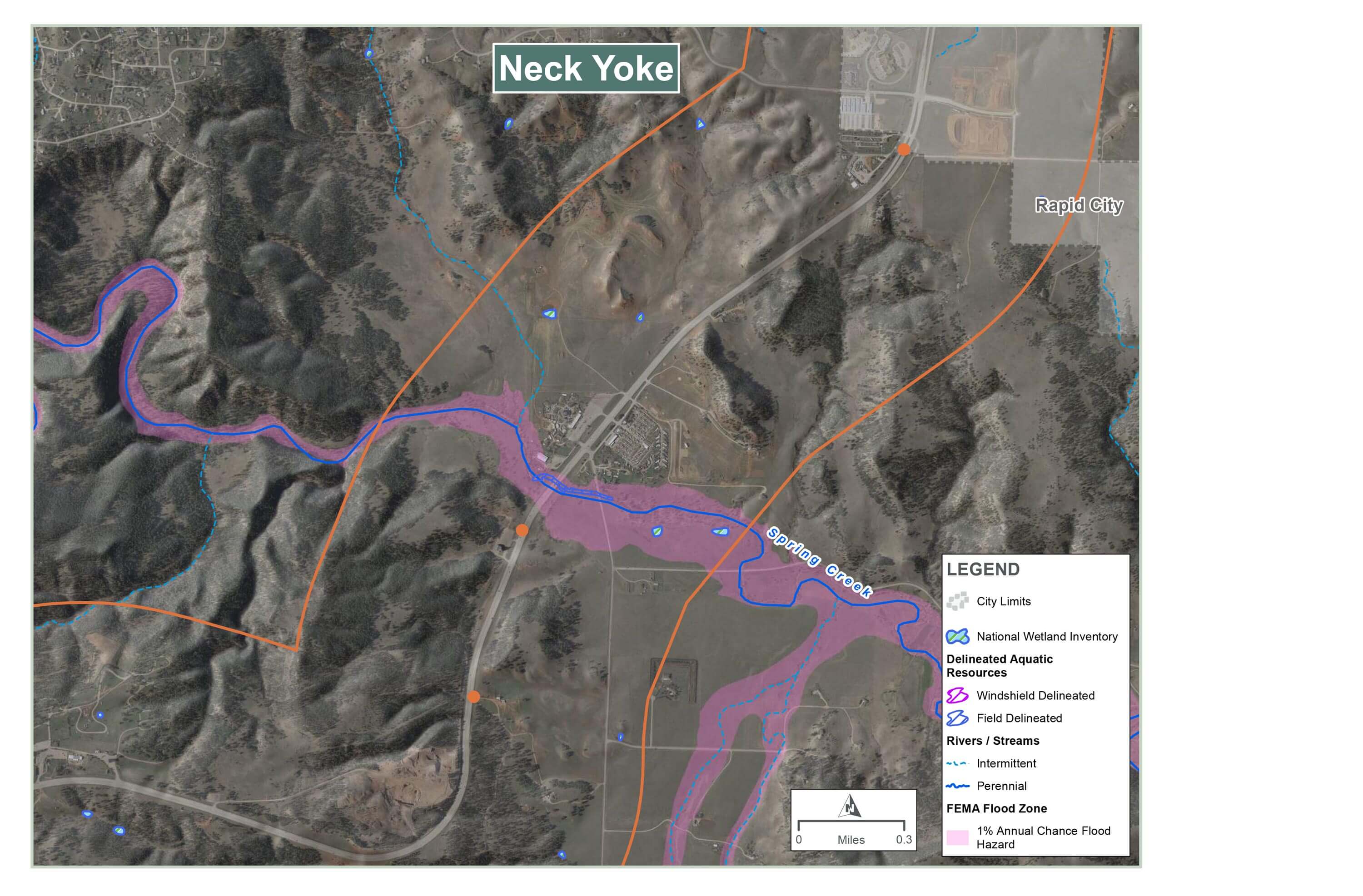
Water Resources:
- Wetlands and 100-year floodplains along Spring Creek are present
Wildlife:
- Habitat surrounds intersection area
- Deer using bridge at Spring Creek to cross under US 16
Hazardous Materials:
- Active underground storage tank (UST) site (Happy Holiday RV Resort)
Cultural Resources:
- Four historic-age properties need to be evaluated for National Register of Historic Places (NRHP) eligibility
- Archaeology surveys to be completed for previously undisturbed areas, especially along Spring Creek
Noise:
- Three areas with measured noise above 66 dBA (see map)
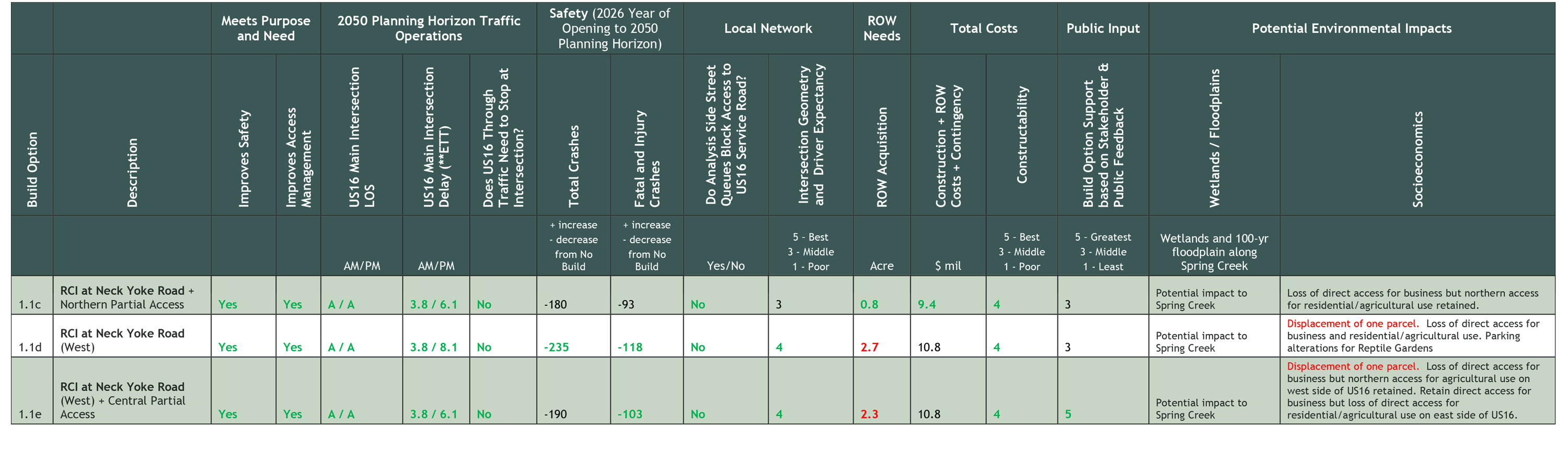
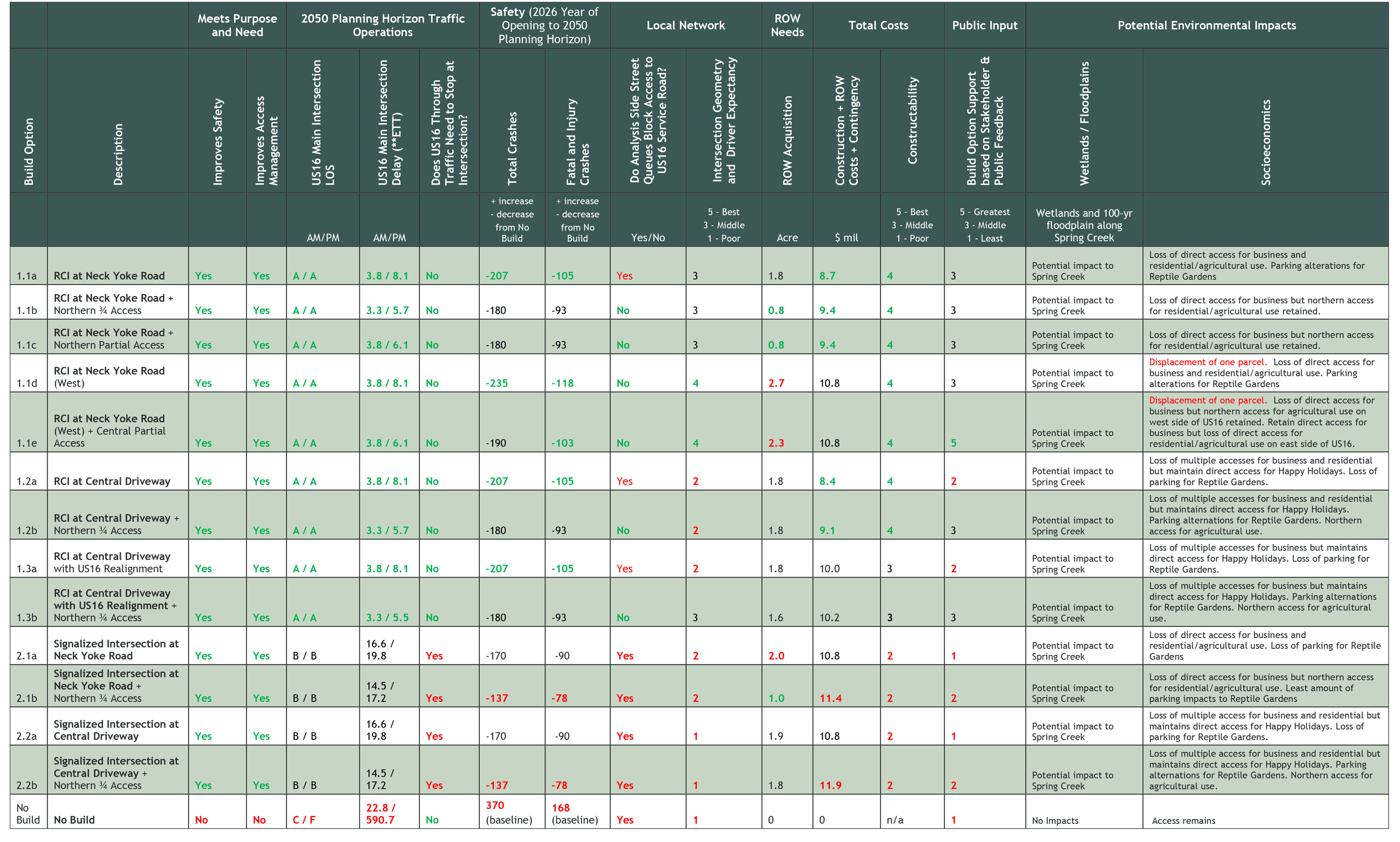
Evaluation Matrix Summary
Each concept was evaluated on how they compare with other concepts in a given category and/or whether they meet study goals. This evaluation is summarized through the following color coding in the evaluation matrix.
- Bold green text indicates a concept measure was favorable compared to the other concepts in a category
- Black text indicates a concept measure was in the middle compared to other concepts in a category
- Bold red text indicates a concept measure was unfavorable compared to the other concepts in a category or the measure does not meet study goals
Evaluation and Screening Process Summary – Download PDF
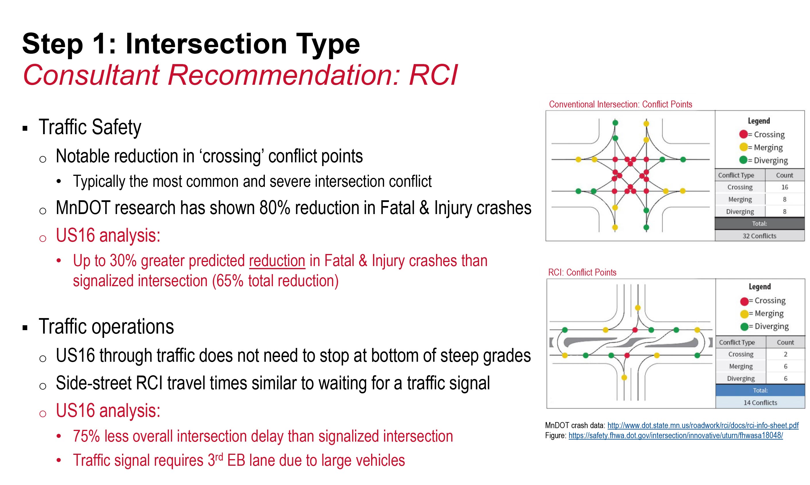
- Intersection type: RCI vs. signalized intersection
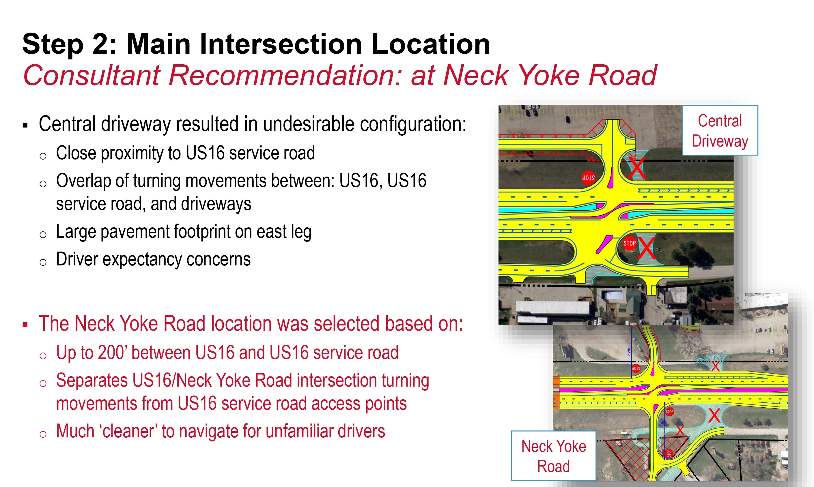
- Main intersection location: Neck Yoke Road vs. central driveway
- Number of access points: one main intersection vs. one main intersection plus a partial northern access
- Result: Consultant Recommendation. Technical recommendation of Build Option to carry forward into the NEPA process (environmental study).
Overview:
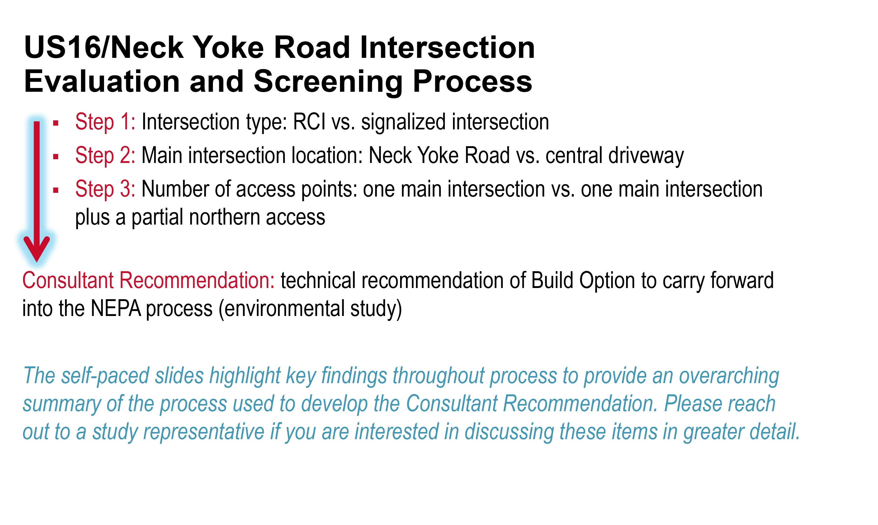
Step 1:
Step 2:
Step 3:
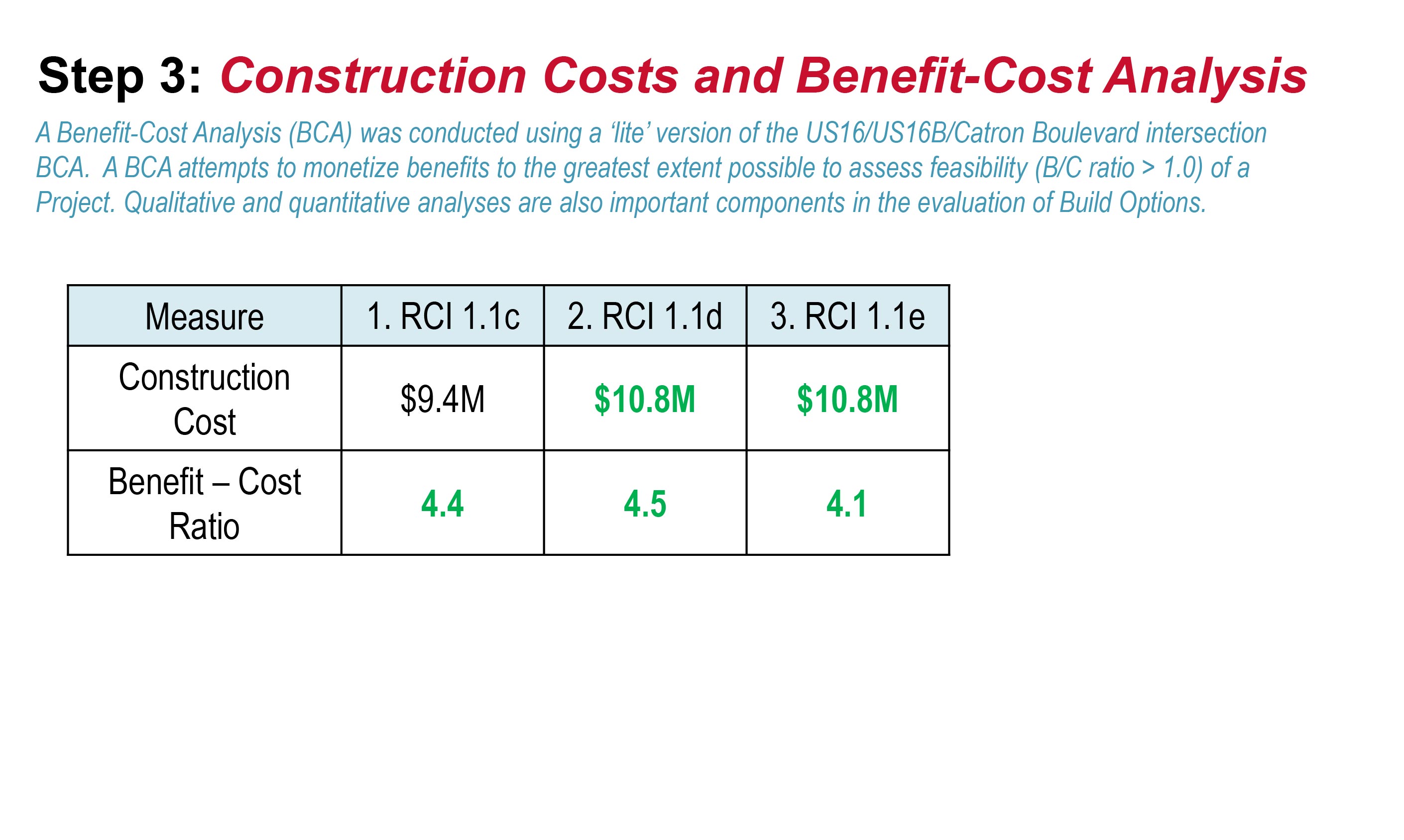
Consultant Recommendation of Technically Feasible Option (Long-Range) – Download PDF
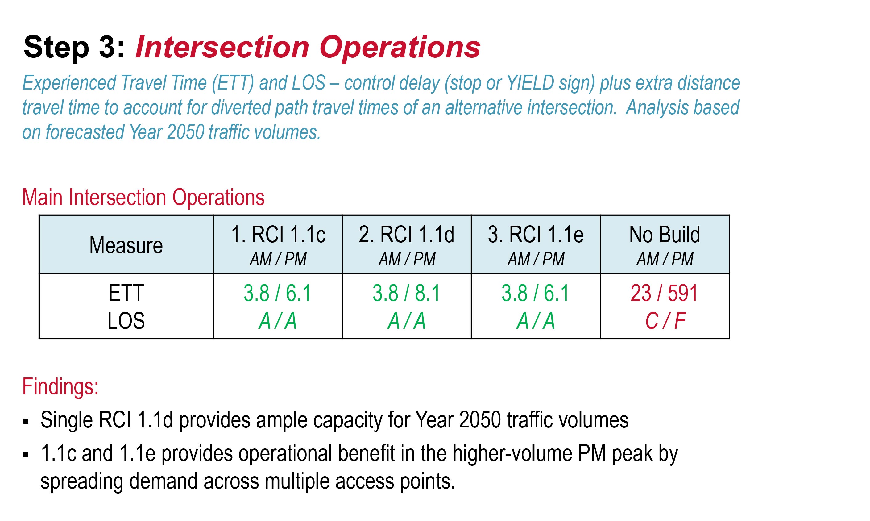
The recommended technically feasible option reflects a long-range vision for the US16/Neck Yoke Road area. This recommendation will be used to help guide the identification and implementation of future projects in the area.
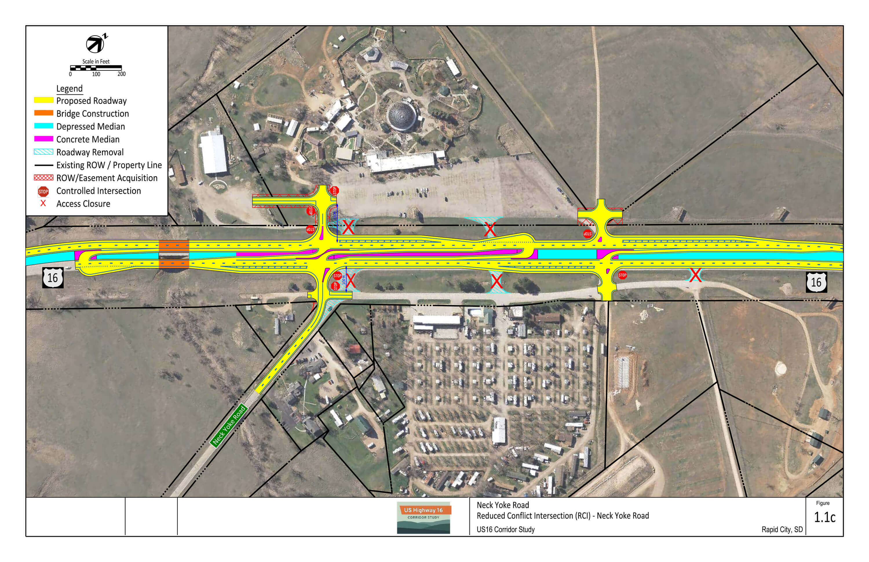
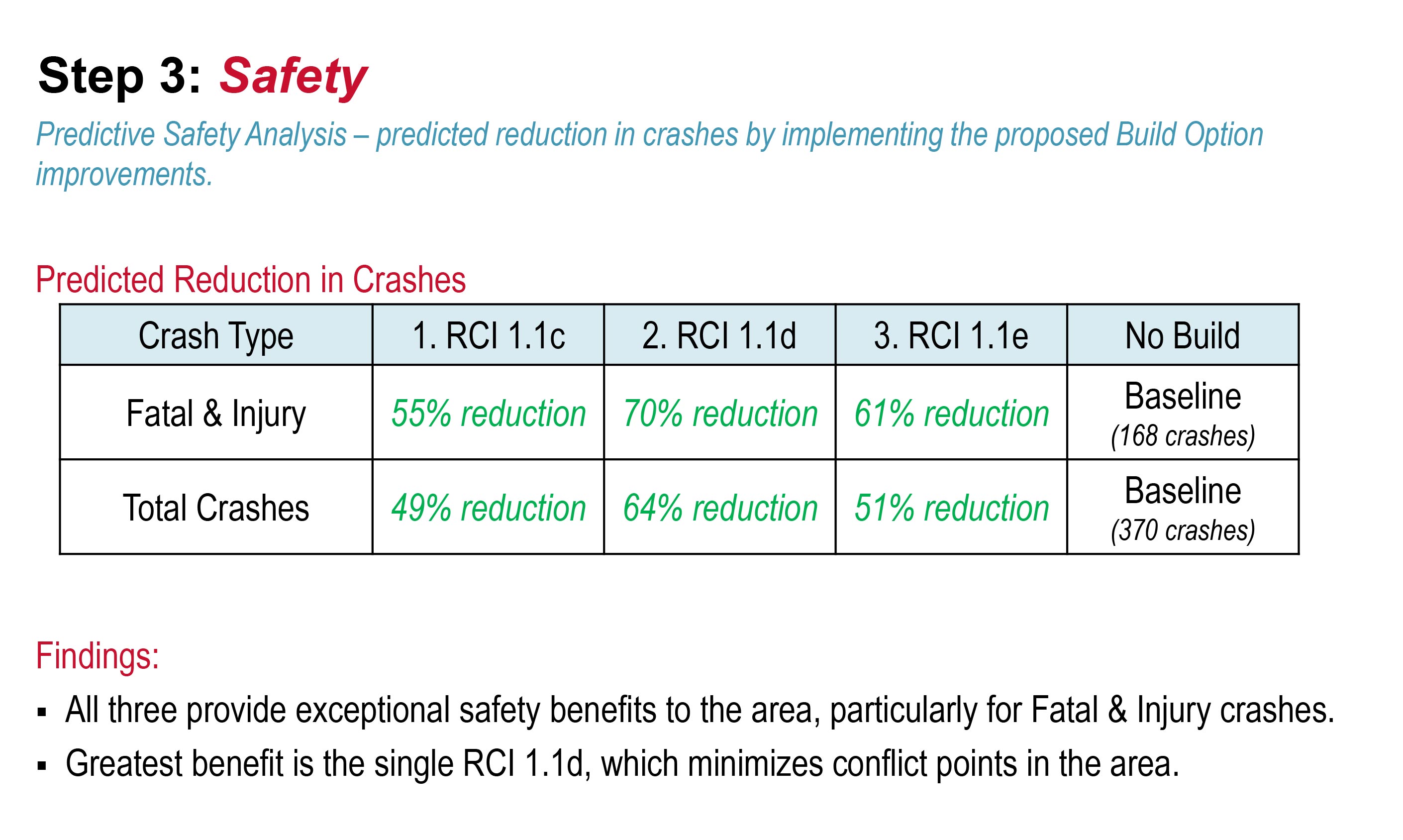
The recommended technically feasible option that best meets the established transportation needs of the US16/Neck Yoke Road intersection area is Build Option 1.1d, a single RCI at a shifted south Neck Yoke Road intersection.
Recommendation – Reduced Conflict Intersection (RCI)
Key Benefits:
- Greatest expected reduction in crashes
- Up to 70% reduction in Fatal and Injury crashes
- Up to 64% reduction in Total crashes
- Intersection operations reflect LOS A.
- US16 mainline through traffic does not need to stop through intersection (free movement)
- Increases separation between US16 mainline and US16 service road intersection
- Local network connectivity to parcels provided via frontage roads
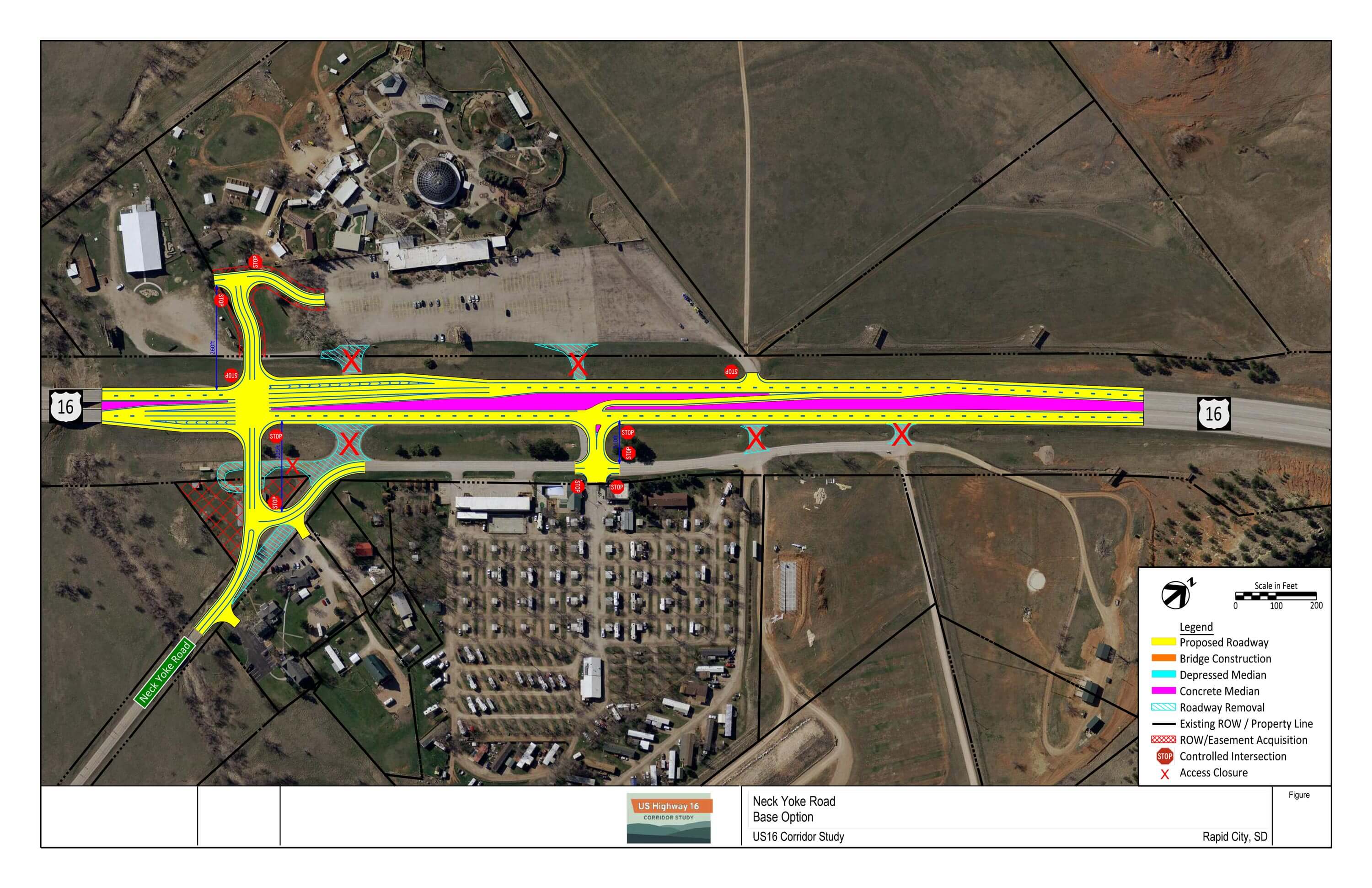
Base Option Reflective of Proposed FY 2025 Project Elements
The SDDOT is planning to incorporate an incremental approach to implementing improvements and working towards the long-range vision for the US16/Neck Yoke Road intersection area. A Base Option was developed to reflect proposed elements to be incorporated as part of the planned Fiscal Year 2025 Project and carried forward to the NEPA (environmental) process.
Proposed Elements
A number of proposed elements address the project Purpose and Need and reflect the first step in working towards the long-range vision for the US16/Neck Yoke Road intersection area.
- Neck Yoke Road realignment
- Main intersection located at 1.1d RCI main intersection location
- Increases separation between US16 mainline and US16 service road
- Access management at minor access intersections north of Neck Yoke Road
- Access closures
- Restricted movements at maintained access points
- No left turns or through movements out of minor access points reduces crossing conflicts
- Can incorporate widened cross-section for median U-turn north of Neck Yoke Road
- US16 mainline bridges do not need to be reconstructed
Other Build Options Considered – Download PDF
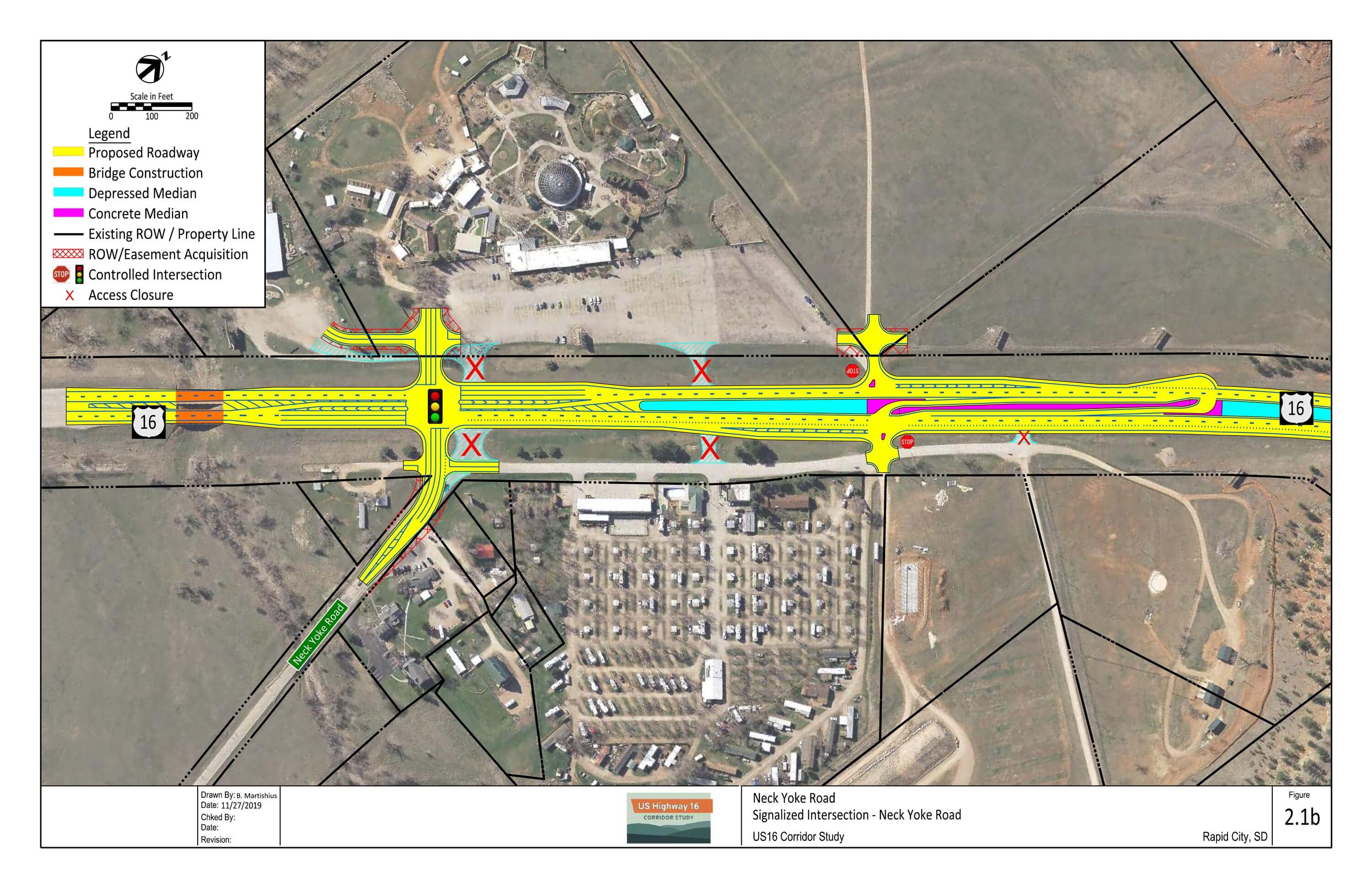
1.1a: RCI at Neck Yoke Road
- RCI at Neck Yoke Road intersection
- All area access points consolidated to main RCI
- New frontage road on west side of US16
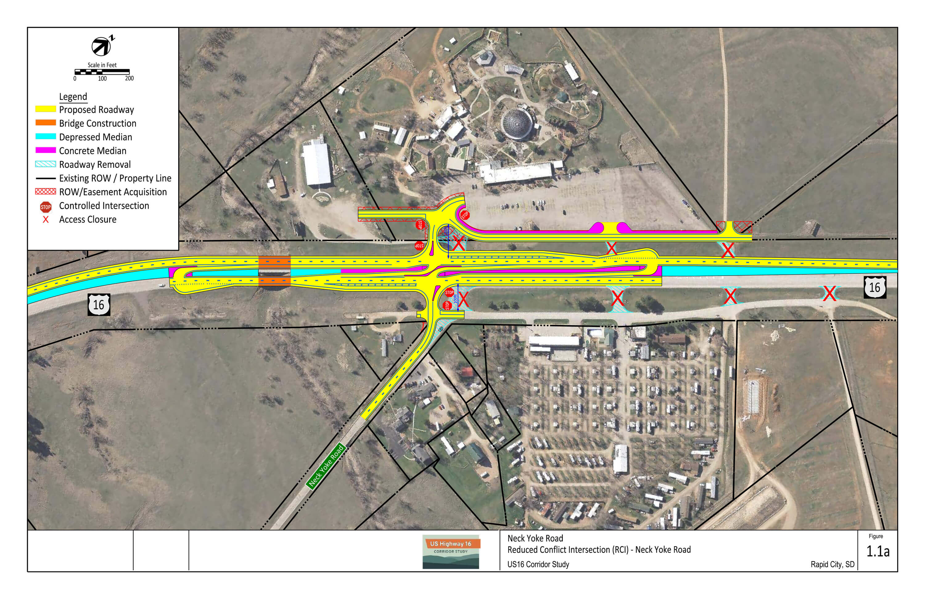
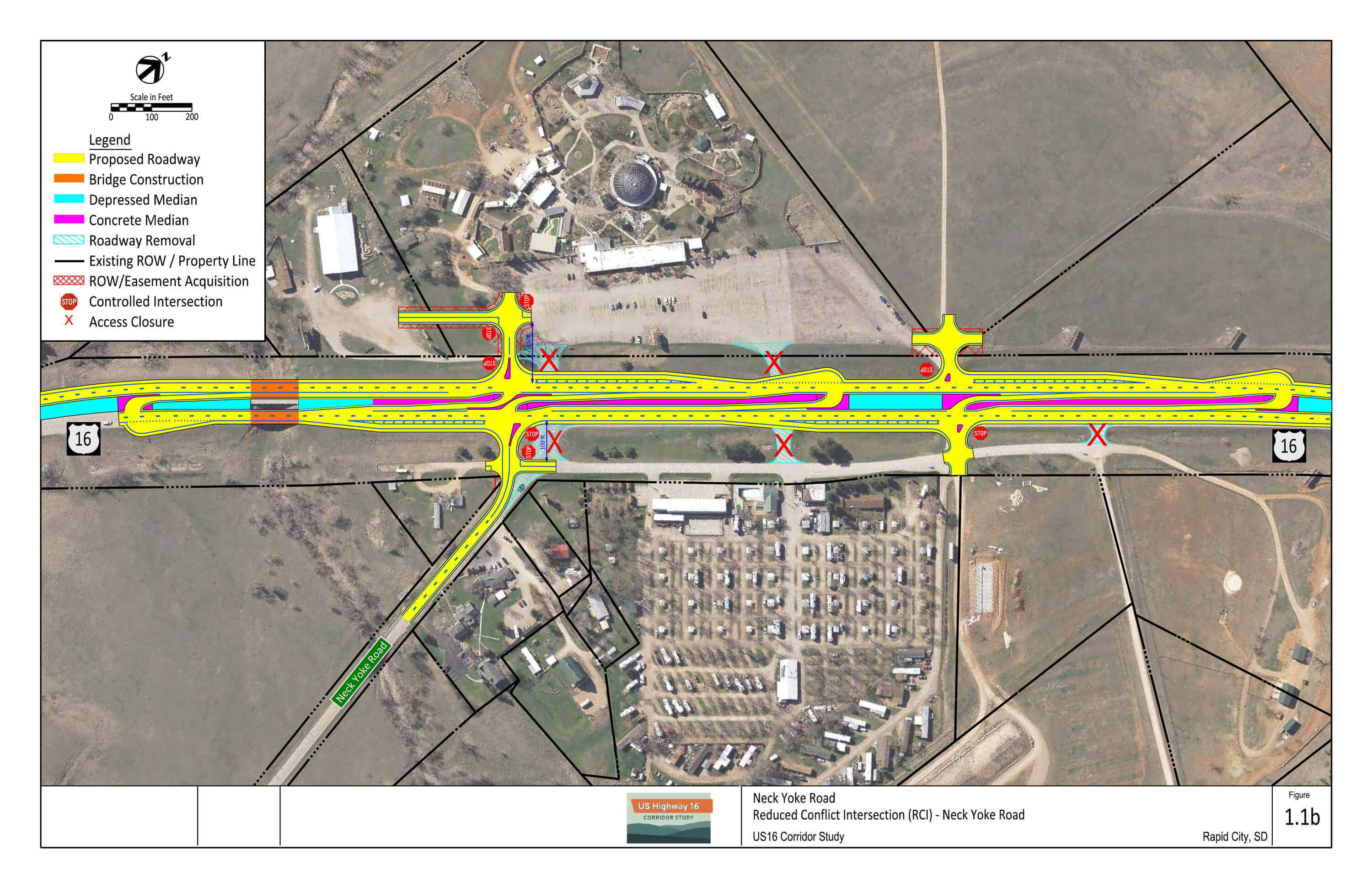
1.1b: RCI at Neck Yoke Road plus Northern ¾ Access
- Similar to 1.1a
- Adds ¾ access at north Reptile Gardens/US16 service road intersection
1.1c: RCI at Neck Yoke Road plus Northern Partial Access
- Similar layout to 1.1b
- Lone difference is omission of EB to WB U-turn at the northern partial access to reduce number of conflict points
1.1d: RCI at Neck Yoke Road (West)
- RCI at Neck Yoke Road intersection, shifted 250 feet west
- All area access points consolidated to main RCI
- New frontage road on west side of US16
1.1e: RCI at Neck Yoke Road (West) plus Central Partial Access (2 options)
- Similar layout to 1.1e
- Adds partial access at central Reptile Gardens/US16 service road intersection
- Option with and without frontage road on west side of US16
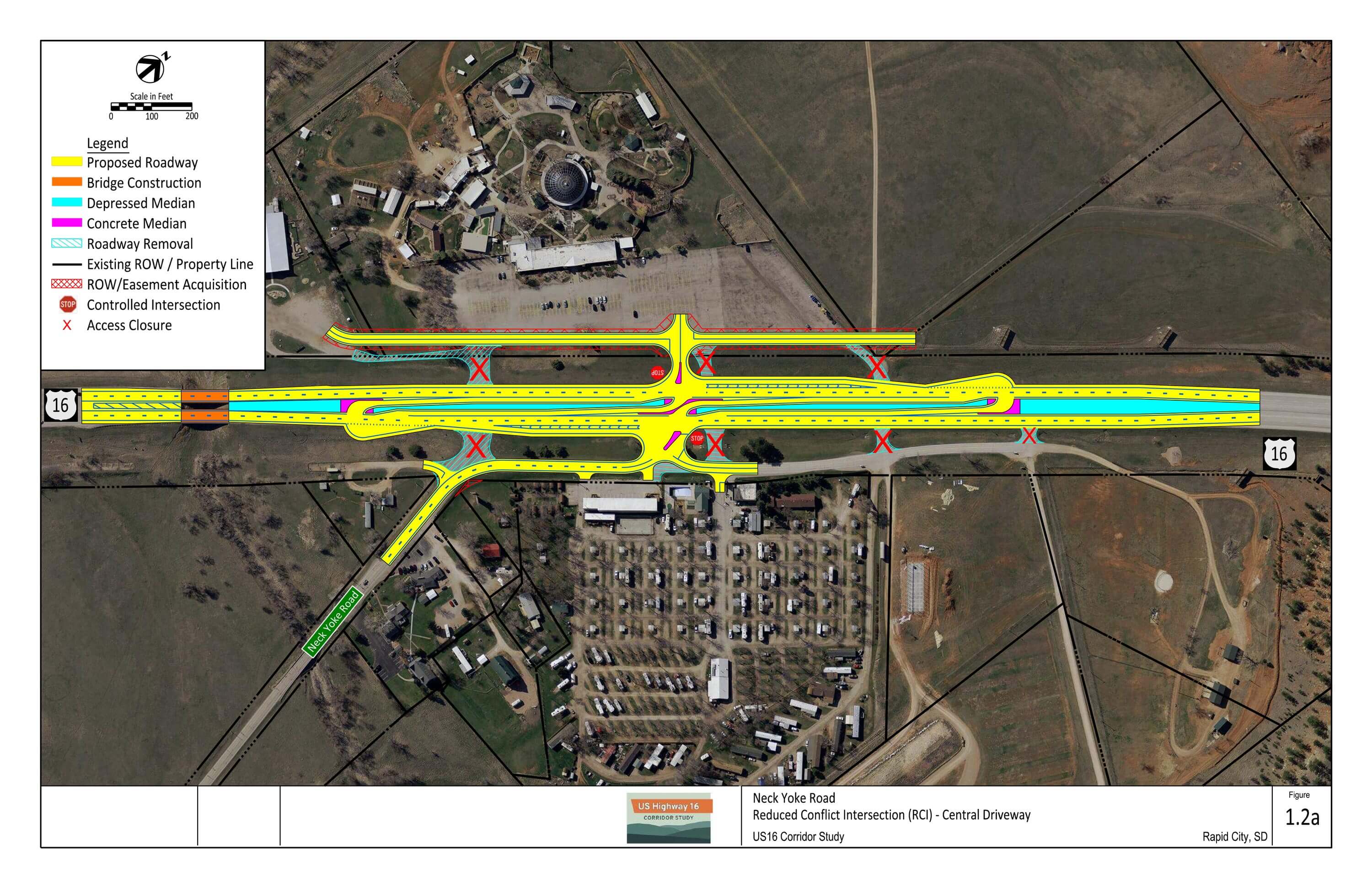
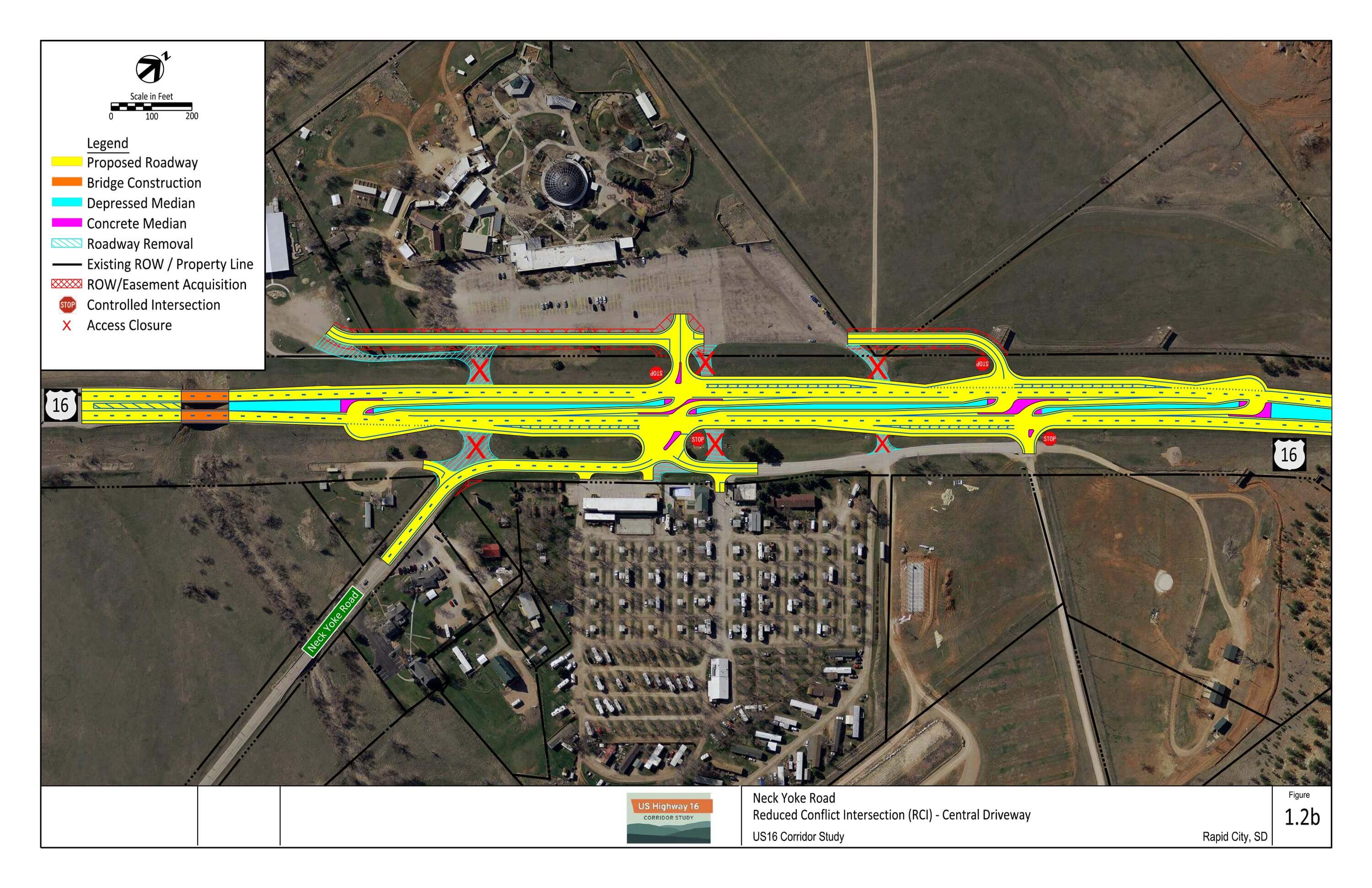
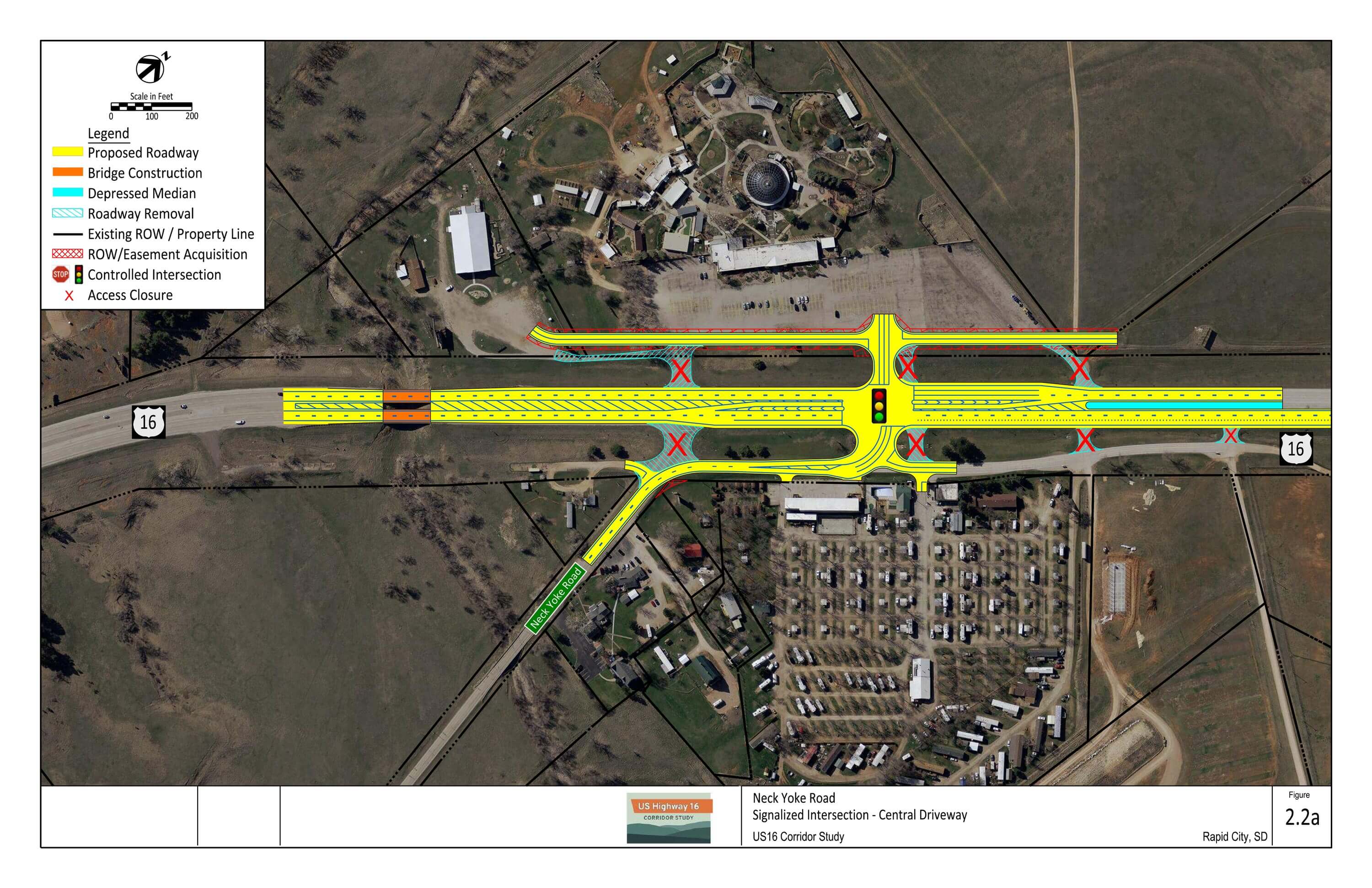
1.2a: RCI at Central Driveway
- RCI at central Reptile Gardens/US16 service road intersection
- All area access points consolidated to main RCI
- New frontage road on west side of US16
1.2b: RCI at Central Driveway plus Northern ¾ Access
- Similar to 1.2a
- Adds ¾ access at the northern-most US16 service road intersection
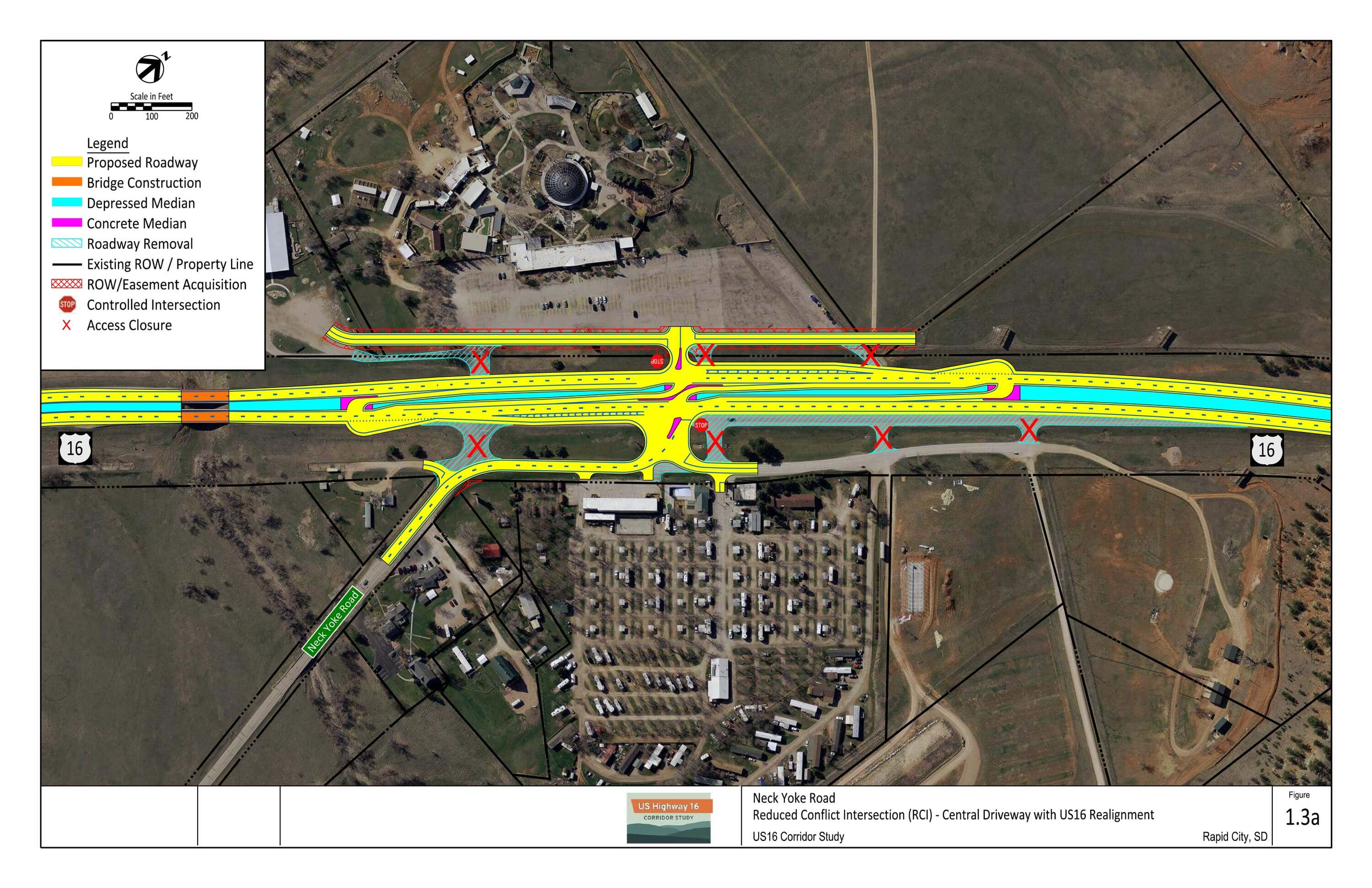
1.3a: RCI at Central Driveway with US16 Realignment
- Similar to 1.2a
- US16 alignment shifted west (20 feet) to increase separation from US16 service road
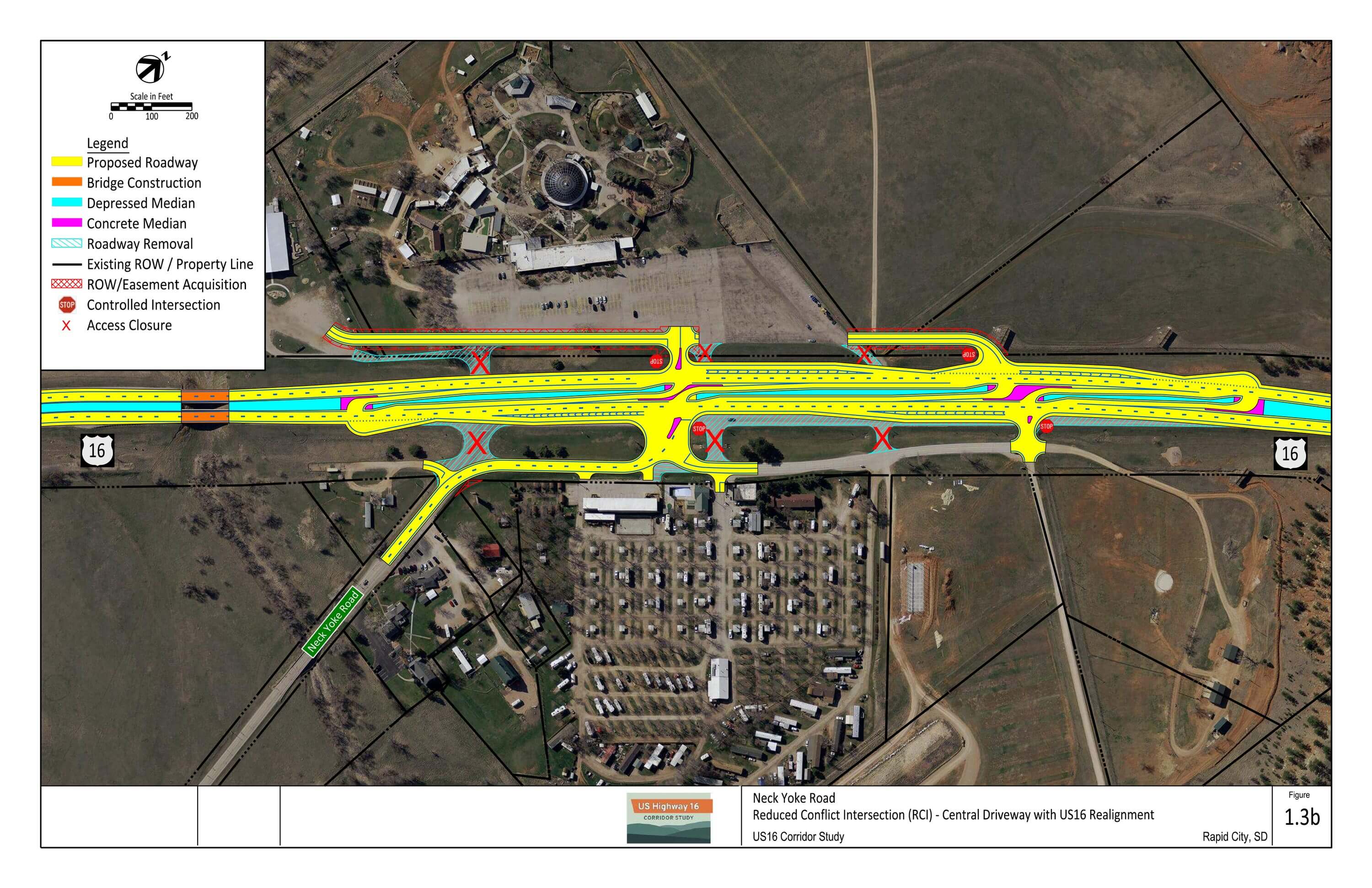
1.3b: RCI at Central Driveway with US16 Realignment plus Northern ¾ Access
- Similar to 1.2b
- US16 alignment shifted west (20 feet) to increase separation from US16 service road
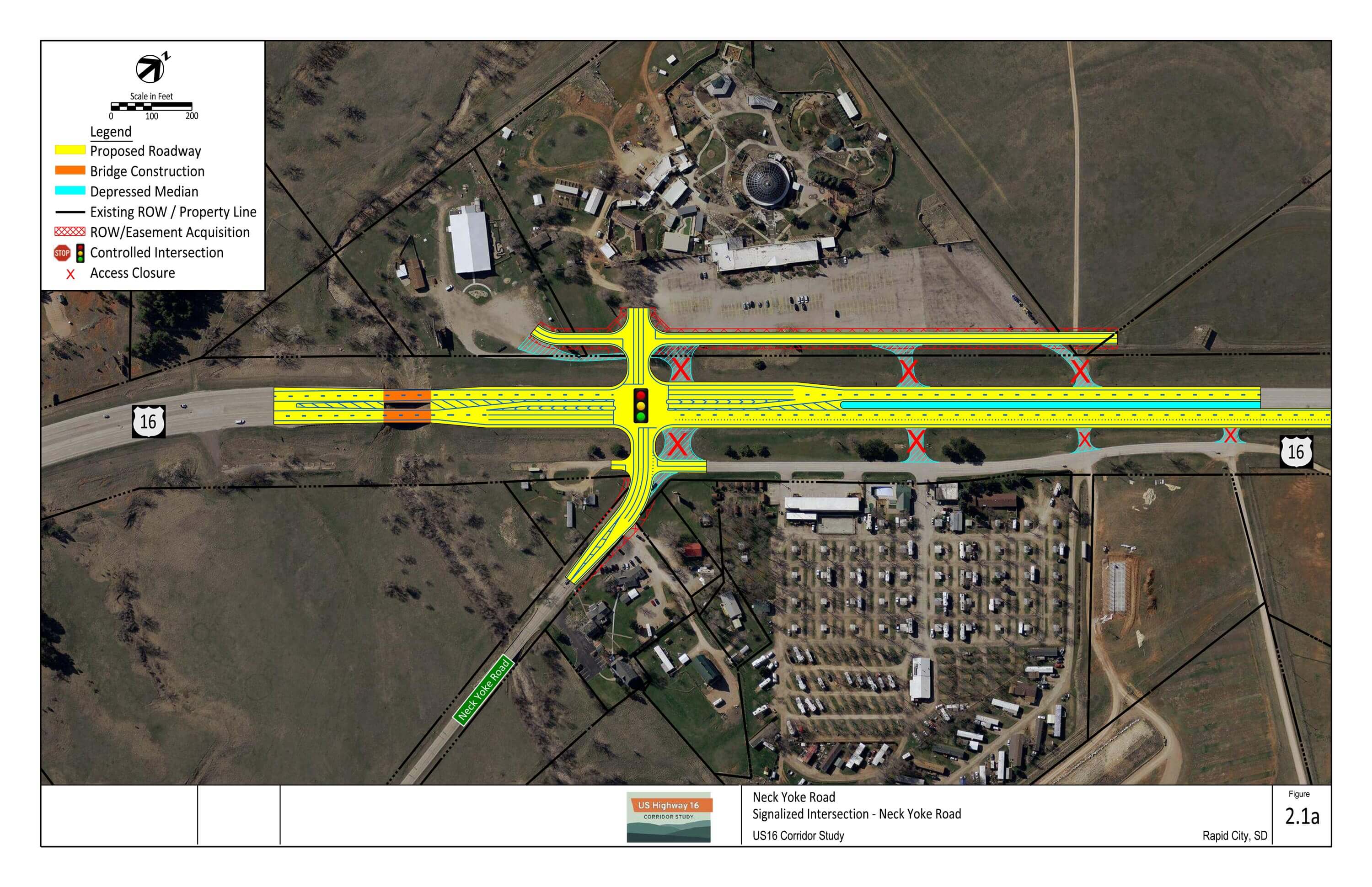
2.1a: Signalized Intersection at Neck Yoke Road
- Signalized intersection (when warranted) at Neck Yoke Road intersection
- Third eastbound lane required to meet signalized intersection LOS goals
- All area access points consolidated to main signalized intersection
- New frontage road on west side
2.1b: Signalized Intersection at Neck Yoke Road plus Northern ¾ Access
- Similar to 2.1a
- Adds ¾ access at north Reptile Gardens/US16 service road intersection
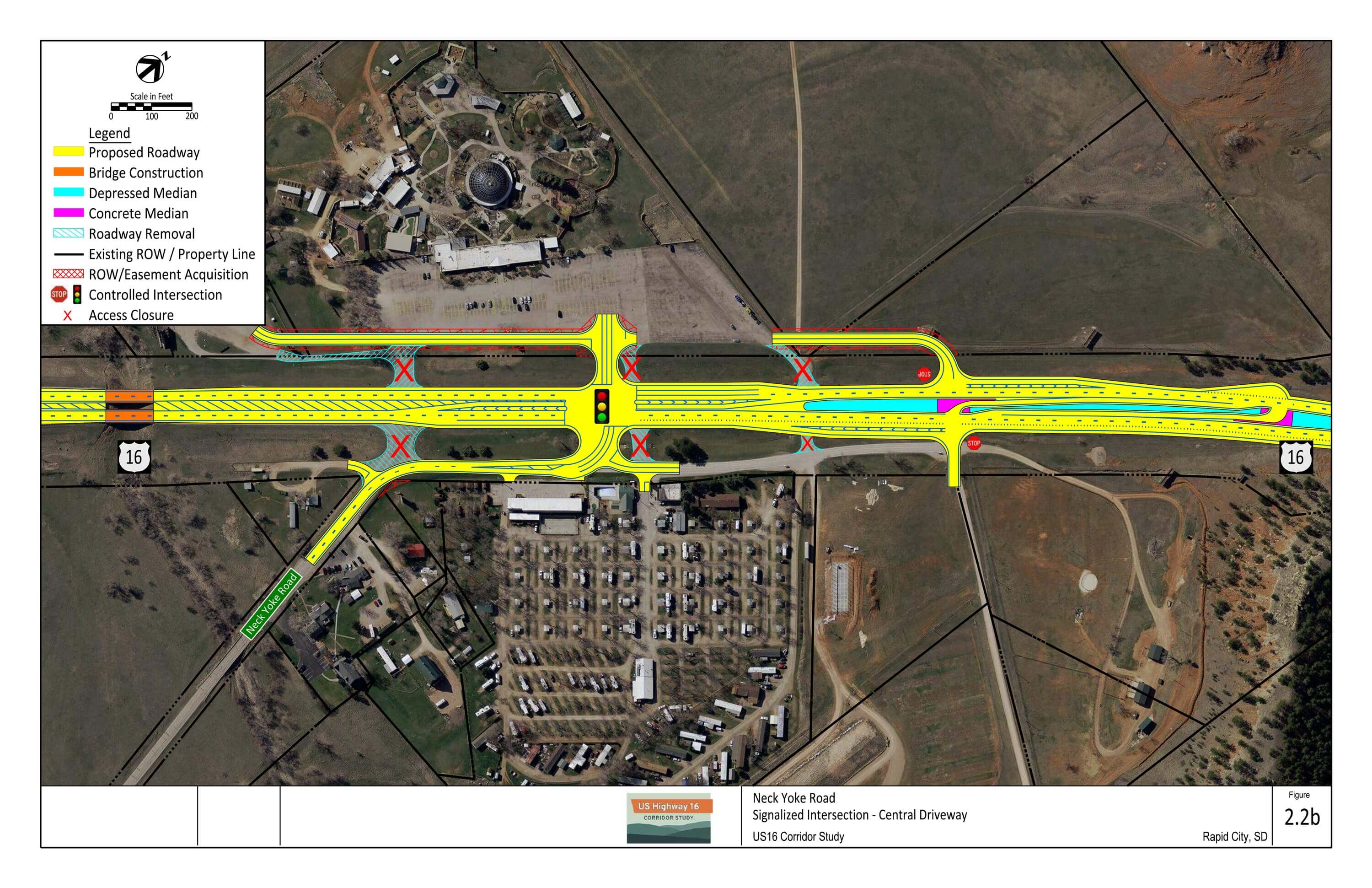
2.2a: Signalized Intersection at Central Driveway
- Signalized intersection (when warranted) at central Reptile Gardens/US16 service road intersection
- Third eastbound lane required to meet signalized intersection LOS goals
- All area access points consolidated to main signalized intersection
- New frontage road on west side
2.2b: Signalized Intersection at Central Driveway plus Northern ¾ Access
- Similar to 2.2a
- Adds ¾ access at the northern-most US16 service road intersection
Full Evaluation Matrix:
Bear Country/Croell Quarry Area
Segment E
Segment Overview
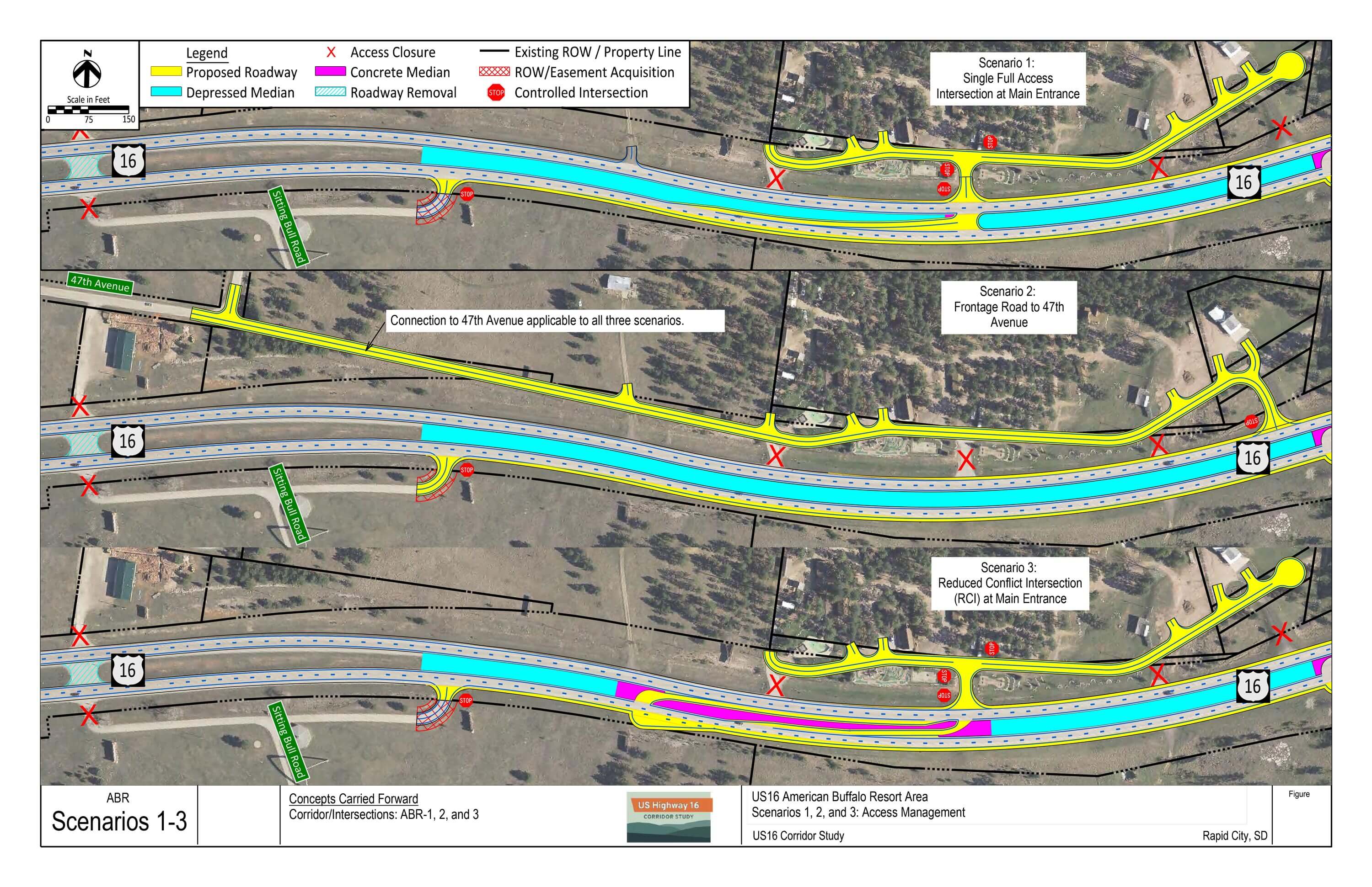
American Buffalo Resort Area Intersection Options – Download PDF
Scenario 1: Single Full Access Intersection and Main Entrance
- Full access main resort entrance
- Eastbound left turn lane extension
- Median through or closure of all other access points
- Frontage road
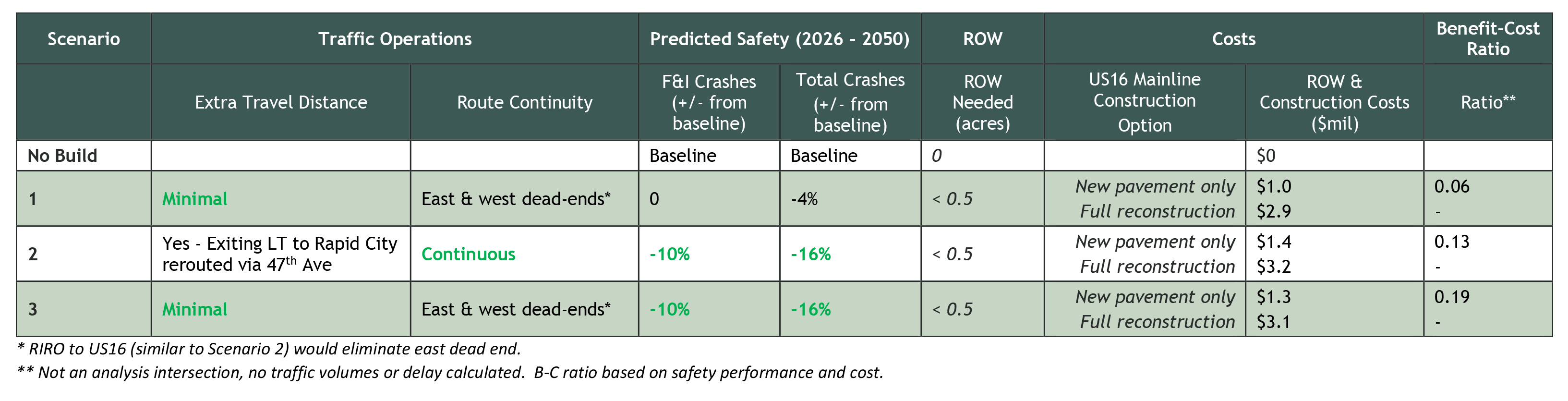
Benefits:
Drawbacks:
- Does not eliminate angle conflicts for left turns out of main entrance
- EB US16 left turn on 6% down grade
- Frontage road divides existing resort features
Scenario 2: Frontage Road to 47th Avenue
- Median through or closure of all other access points
- Frontage road to 47th Avenue West
- RIRO at east end to provide circulation
Benefits:
- Greatest reduction of conflict points
- 10% reduction in predicted F&I crashes
- Eliminates right angle conflict for left turns out of all existing access points
- Removes EB US16 left turn from 6% down grade
- Greatest separation between US16 and first frontage driveway access
Drawbacks:
- Highest cost
- Wilderness Canyon Road approximately 0.6 miles from main entrance
- Signing/wayfinding will be important for eastbound traffic as resort is not visible form Wilderness Canyon Road intersection
- Frontage road divides existing resort features
Scenario 3: RCI at Main Entrance
- RCI (full access) at main resort entrance
- Eastbound left turn lane extension
- Median through or closure of all other access points
- Frontage road
Benefits:
- 10% reduction in predicted F&I crashes
- Eliminates right angle conflict for left turns out of all existing access points
Drawbacks:
- EB US16 left turn on 6% down grade
- Frontage road divides existing resort features
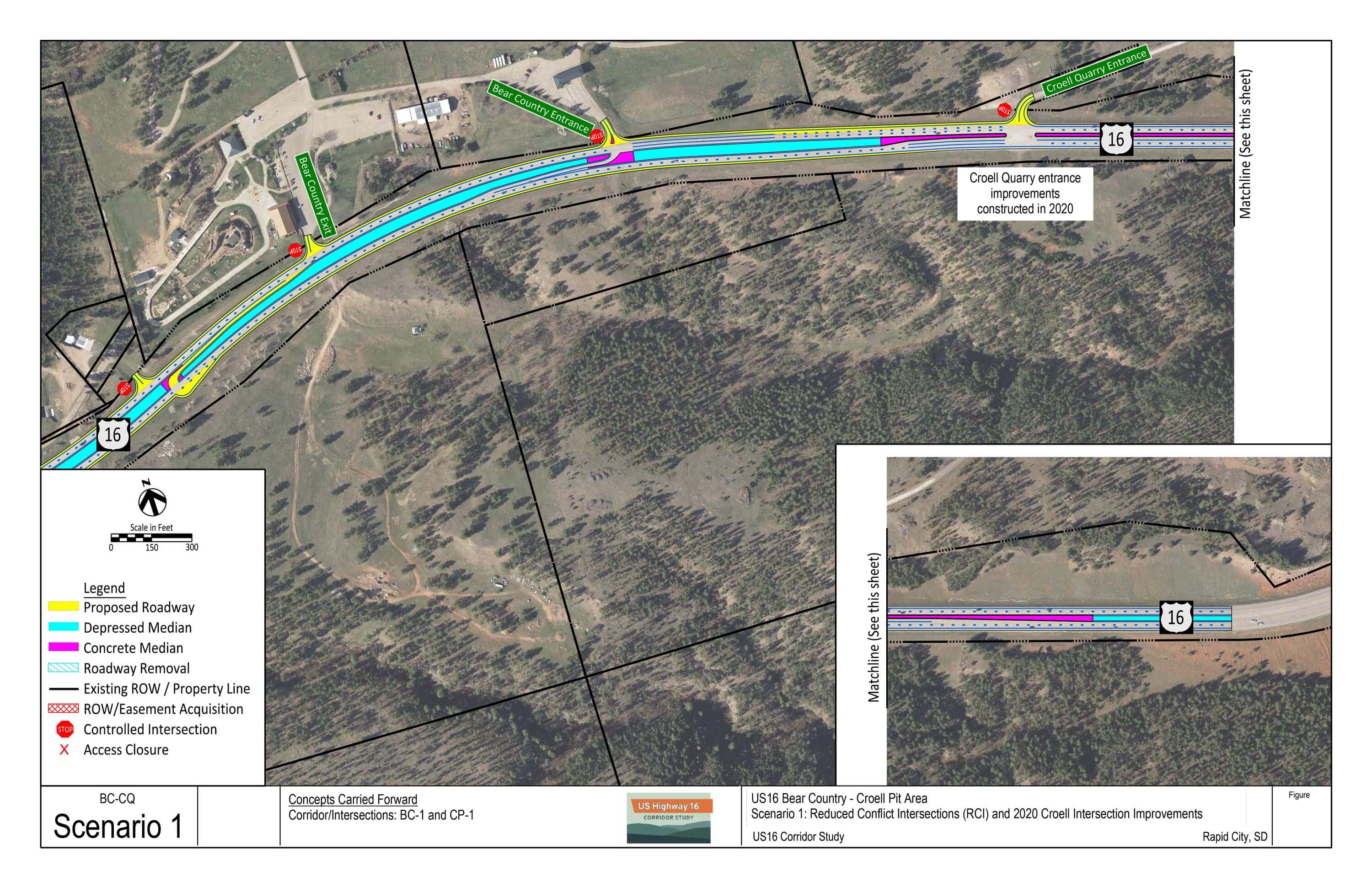
Bear Country/Croell Quarry Area Intersection Options – Download PDF
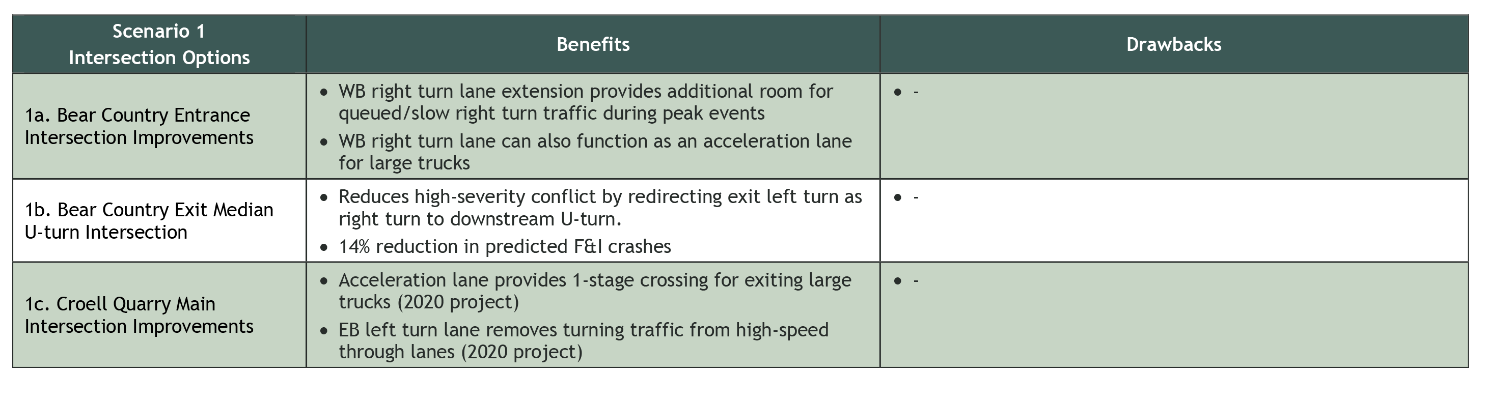
Scenario 3: Intersection Improvements
- Bear Country Entrance
- Maintain eastbound left turn lane
- Westbound right turn lane extension
- Bear Country Exit
- Median U-turn intersection
- Croell Quarry Main Intersection
- Eastbound left turn lane (2020 project)
- Southbound to eastbound acceleration lane (2020 project)
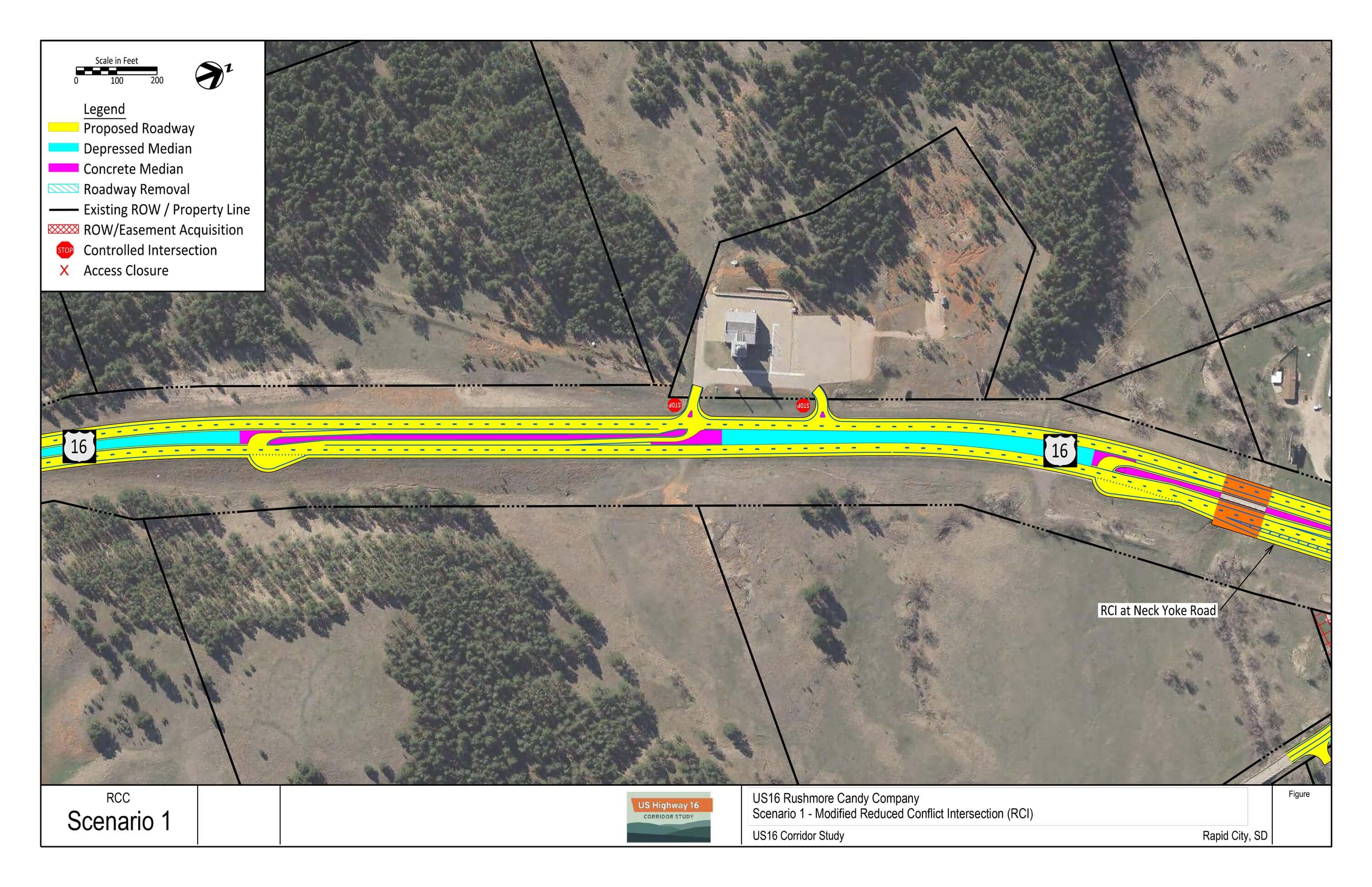
Rushmore Candy Company Access Option – Download PDF
Scenario 1: Modified RCI
- RCI at west access
- Adds eastbound left turn lane
- RIRO at east access
Croell Quarry Horizontal Curve
High friction surface treatment was added to the eastbound direction in Fall 2019. SDDOT has seen significant benefit statewide from these applications in reducing run off the road crashes, which has been an issue through this curve.
Busted Five/Wilderness Canyon Area
Segment F
Segment Overview
Corridor Build Options – Download PDF
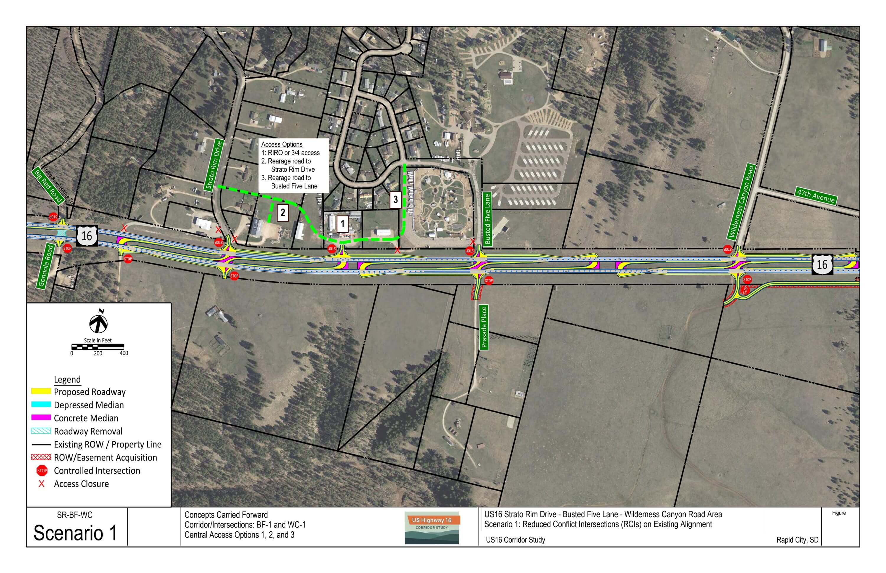
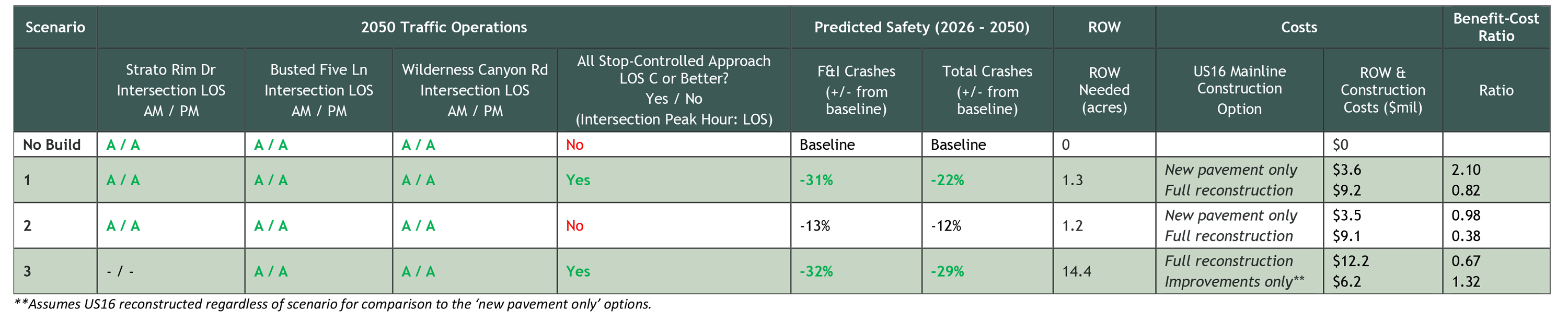
Scenario 1: Reduced Conflict Intersections (RCIs) on Existing Alignment
- RCIs at Wilderness Canyon Road, Busted Five Lane, and Strato Rim Drive
- Christmas Store (and surrounding parcels) access options:
- RIRO, ¾, or rearage connections to Strato Rim Drive or Busted Five Lane
Benefits:
- 31% predicted reduction in F&I crashes
- All intersection approach delay LOS C or better
- Greatest B/C ratio (2.10)
Drawbacks:
- Some U-turns may line up with existing access points, which creates new turning conflicts (mitigation possible)
- Frontage/rearage connections could add to cost
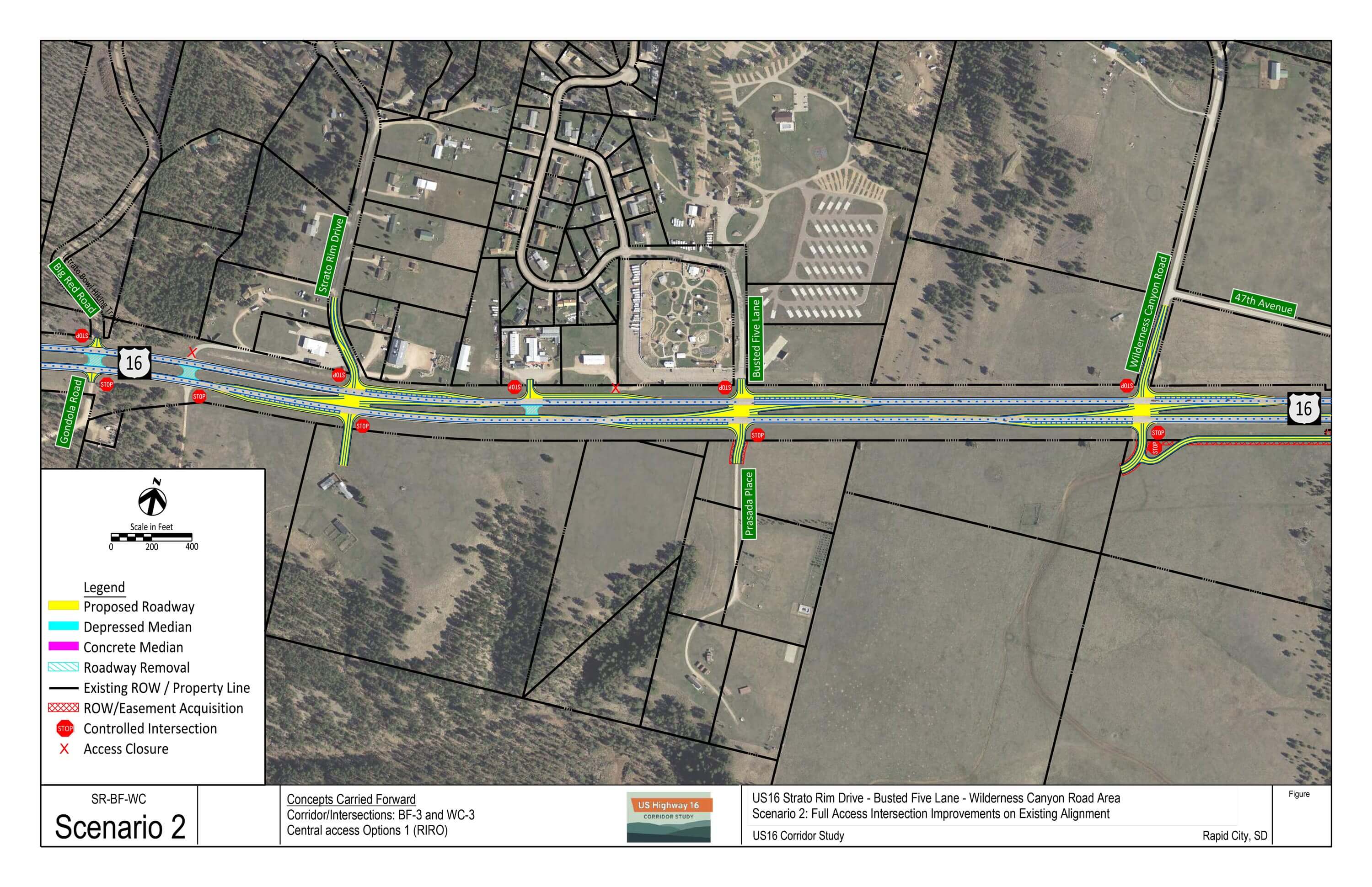
Scenario 2: Full Access Intersection Improvements on Existing Alignment
- Wilderness Canyon Road, Busted Five Lane, and Strato Rim Drive intersection improvements
- Southbound to eastbound left turn acceleration lane
- Warranted turn lanes
- Christmas Store (and surrounding parcels) RIRO access
Benefits:
- 13% predicted reduction in F&I crashes
- Facilitates single-stage side-street left turn movement (left turn into acceleration lane)
Drawbacks:
- Greatest stop-controlled delay at all three intersections
- Least safety benefit of corridor scenarios
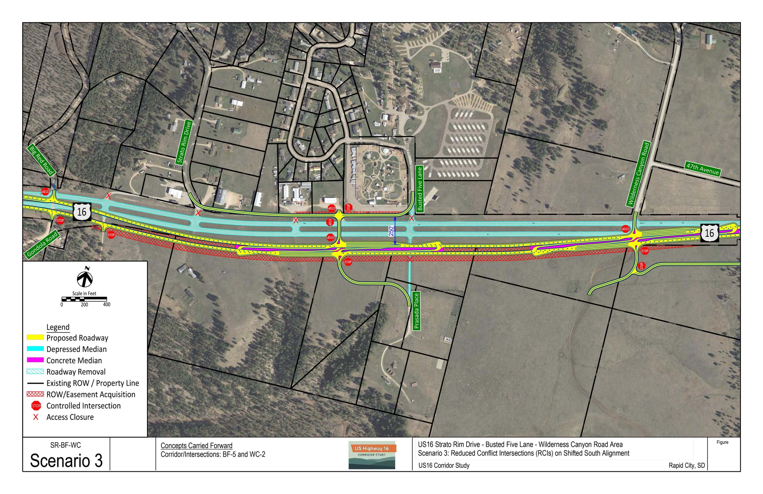
Scenario 3: RCIs on Shifted South Alignment
- New US16 alignment shifted south
- Rural cross-section
- 250-foot separation between US16 and first side-street driveway or intersection
- Strato Rim Drive/Busted Five Lane combined RCI at 0.5-mile spacing from Wilderness Canyon Road
- RCI at Wilderness Canyon Road
Benefits:
- Greatest reduction in total number of conflict points
- 32% predicted reduction in F&I crashes
- All intersection approach delay LOS C or better
- Greatest separation between US16 and first crossroad intersection
Drawbacks:
- Requires reconstruction of US16
- Greatest cost and ROW need
All Scenarios
Benefits:
- Improves intersection traffic operations
- Improves predicted safety
- Reduces total number of conflict points
- Provides access framework for future development
Evaluation Summary
Click the image above to enlarge.
Rockerville Area & West
Segment G
Segment Overview
Corridor Build Options – Download PDF
All three scenarios were developed to provide the following benefits:
- Remove redundant ramps
- Improve local network connectivity and reduces need for short-distance local travel on US16
- Reduce total number of intersection conflict points
- Support area-wide incremental improvements through a long-range plan
- Provide access framework for future development
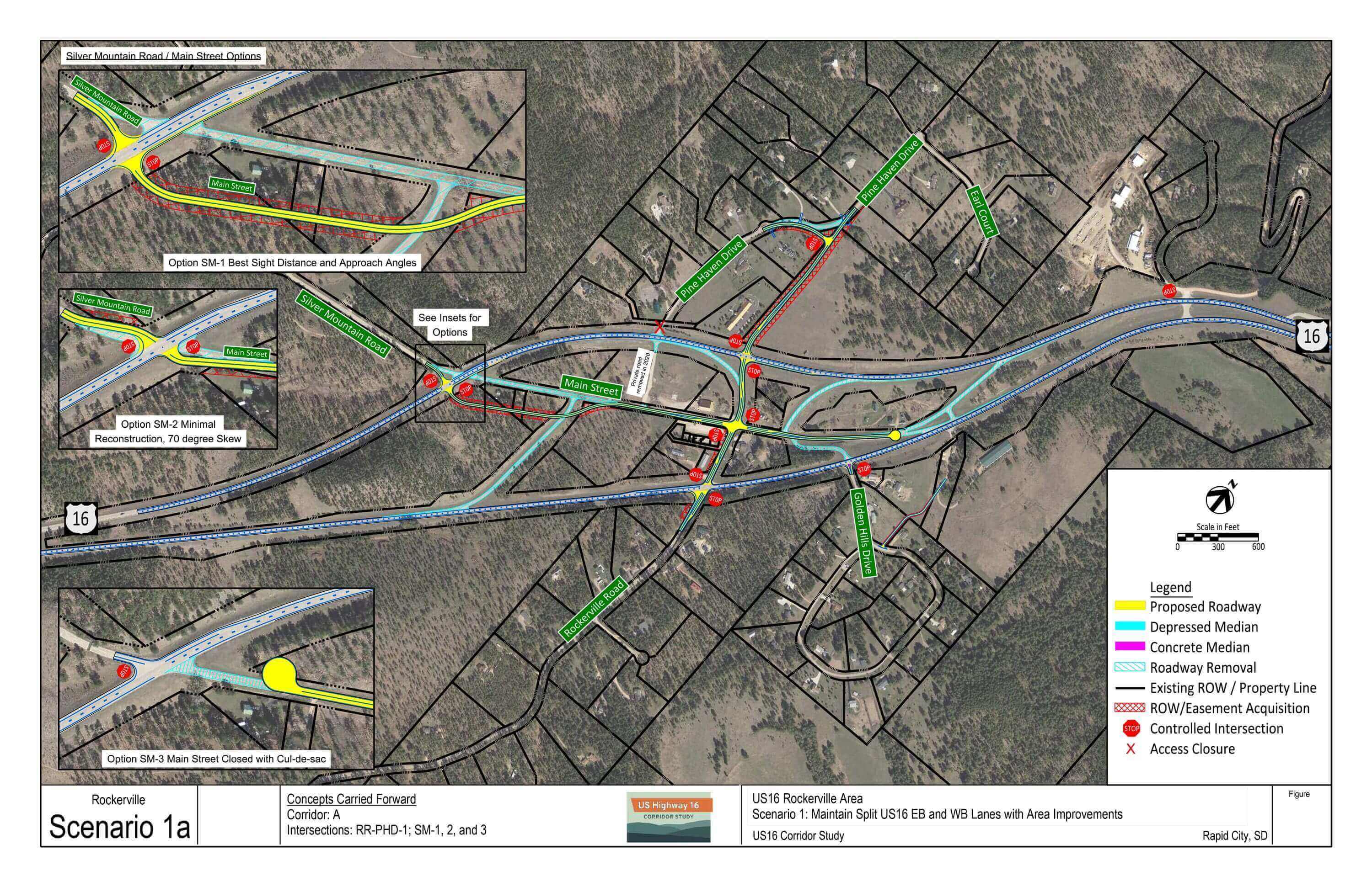
Scenario 1: Maintain Split US16 EB and WB Lanes with Area Improvements
- Maintains existing US16 alignment
- Removes redundant ramps
- Pine Haven Drive extension to Rockerville Road
- US16 EB/Rockerville Road intersection improvements (skew)
- US16 WB/Main Street intersection improvements (skew and sight distance)
Benefits:
- Does not require US16 mainline reconstruction
- Up to 29% predicted reduction in F&I crashes
- Removes internal roadways near potential wetland areas
Drawbacks:
- Some intersection options increase need for short-distance local travel on US16
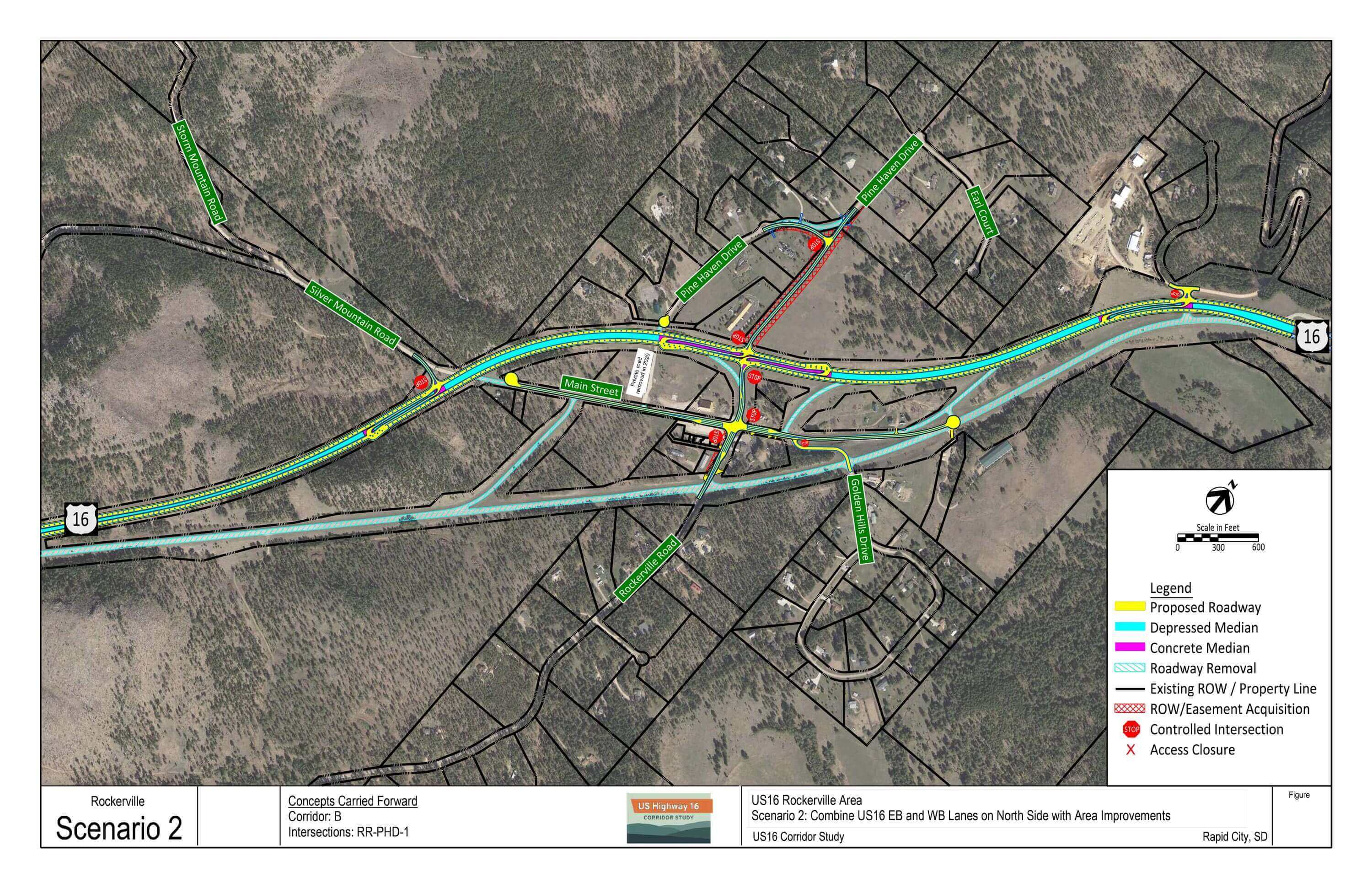
Scenario 2: Combine US16 EB and WB Lanes on North Side with Area Improvements
- Reconstructs US16 north of Rockerville (existing US16 WB ROW)
- Removes all ramps
- Pine Haven Drive extension to Rockerville Road
- US16 Intersection improvements (RCIs)
Benefits:
- Removes all ramps
- 51% predicted reduction in F&I crashes
- Rockerville development no longer within US16 median
- Removes wildlife barrier with current US16 split, improves habitat connectivity
Drawbacks:
- Requires reconstruction of US16
- Cost
- Larger US16 footprint crossing potential wetland areas
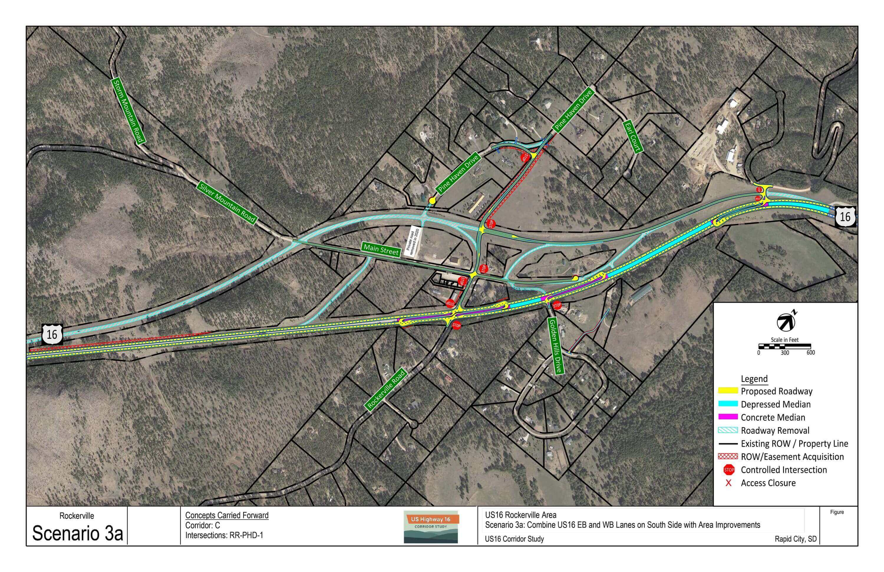
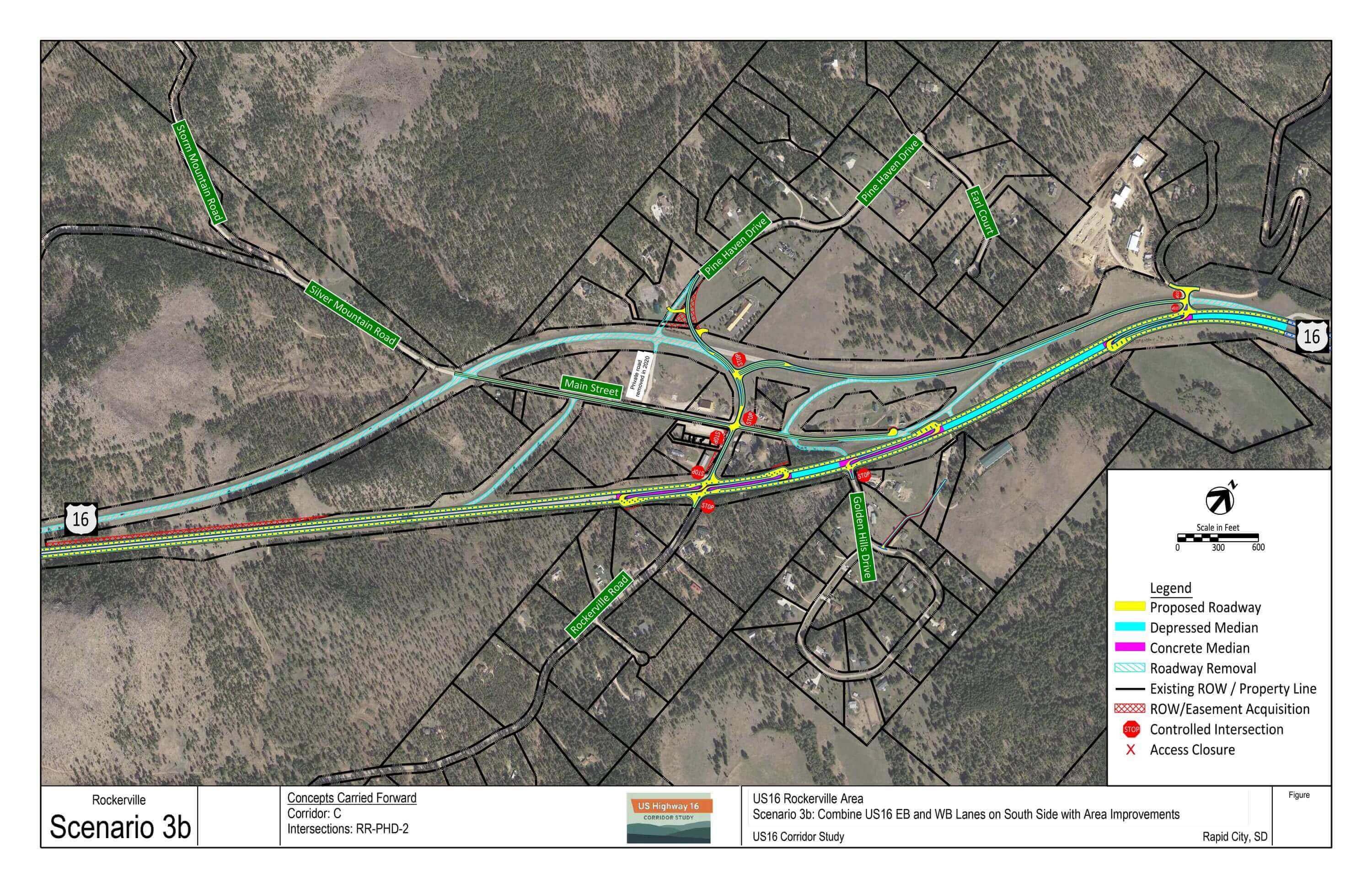
Scenario 3: Combine US16 EB and WB Lanes on South Side with Area Improvements
- Reconstructs US16 south of Rockerville (existing US16 EB ROW)
- Removes all ramps
- Pine Haven Drive extension to Rockerville Road (two options)
- US16 Intersection improvements (RCIs)
Benefits:
- Removes all ramps
- 44% predicted reduction in F&I crashes
- Rockerville development no longer within US16 median
- Removes wildlife barrier with current US16 split, improves habitat connectivity
- Removes US16 and internal roadways near potential wetland areas
Drawbacks:
- Requires reconstruction of US16
- Cost
- Potential for greatest rock excavation impact outside of existing ROW
- Additional local network may be required when compared to Scenario 2
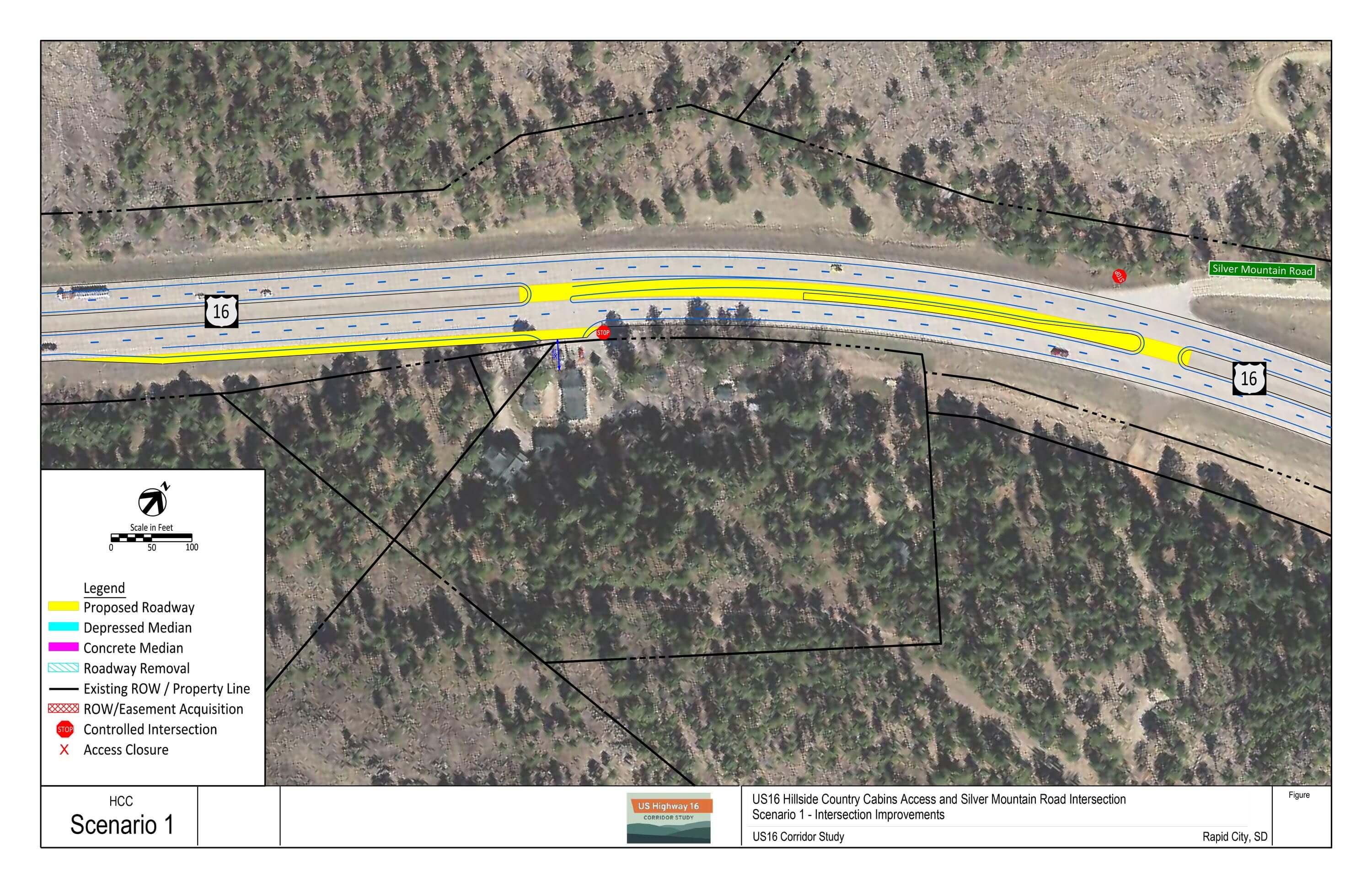
Hillside Country Cabins Access and Silver Mountain Road Intersection Option
Conceptual layout looks at potential westbound left turn lane and eastbound right turn lane into Hillside Country Cabins to gauge feasibility and potential impacts. Turn lanes were noted as possible safety improvements to remove slow or stopped turning traffic from the US16 mainline through lane.
Evaluation Summary
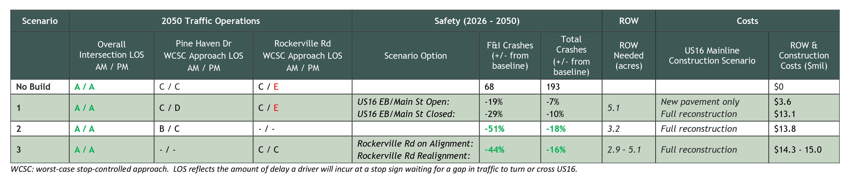
Click the image above to enlarge.
Urban Area Bicycle & Pedestrian Plan
Corridor Layout Plan – Download PDF
Plan Overview
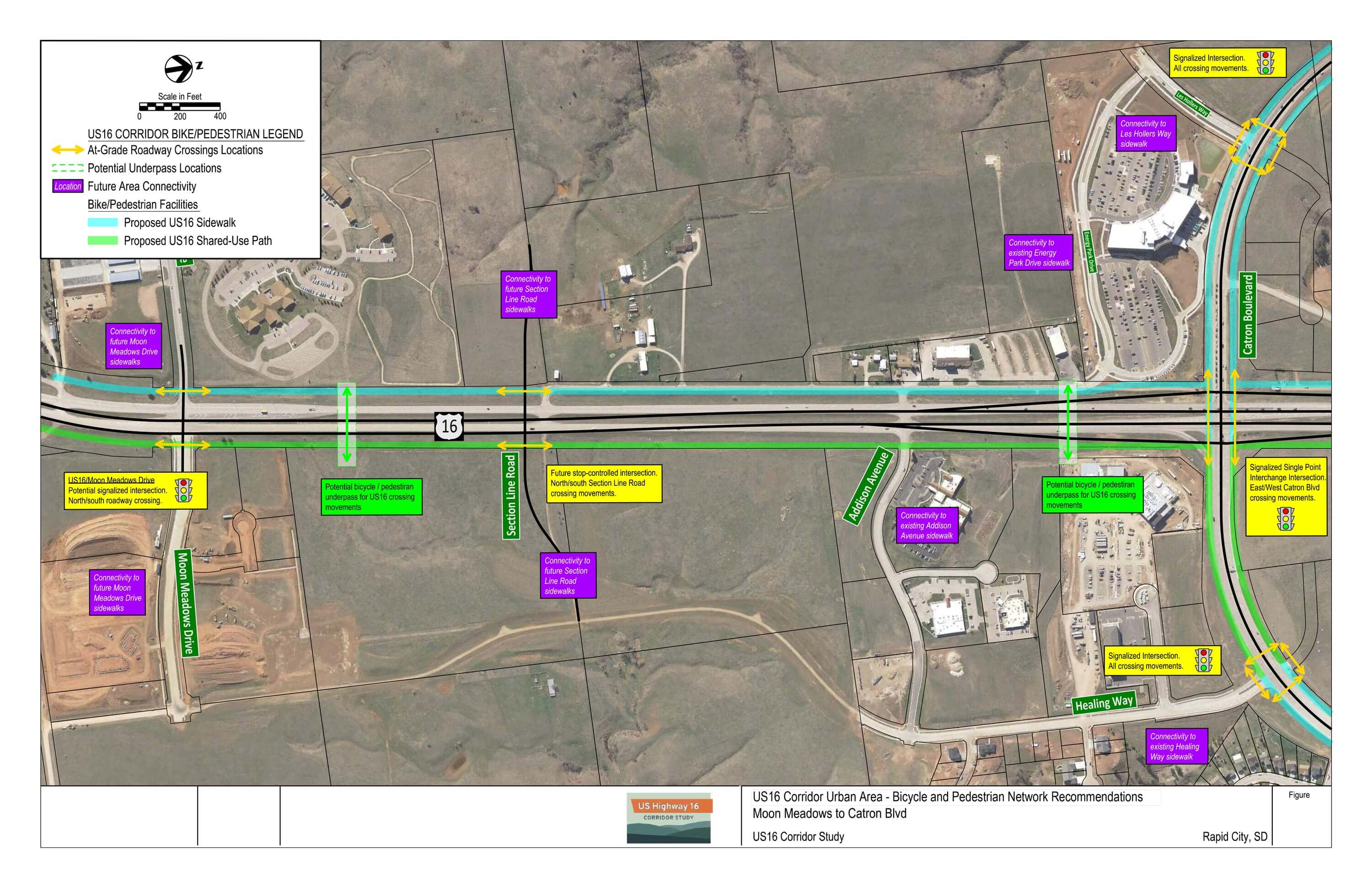
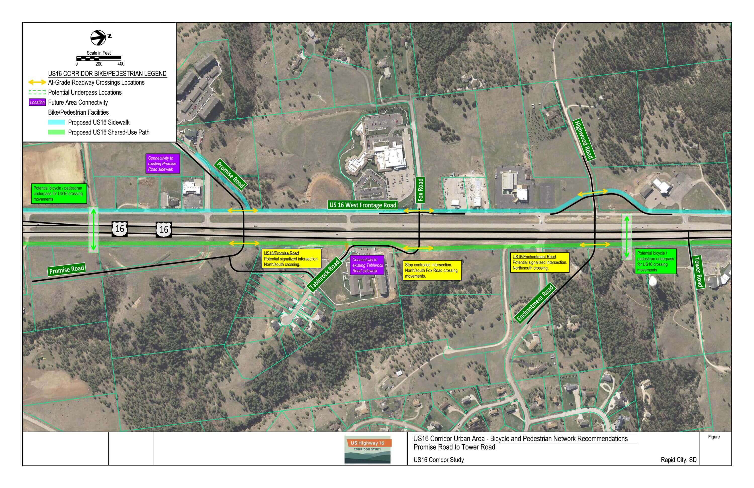
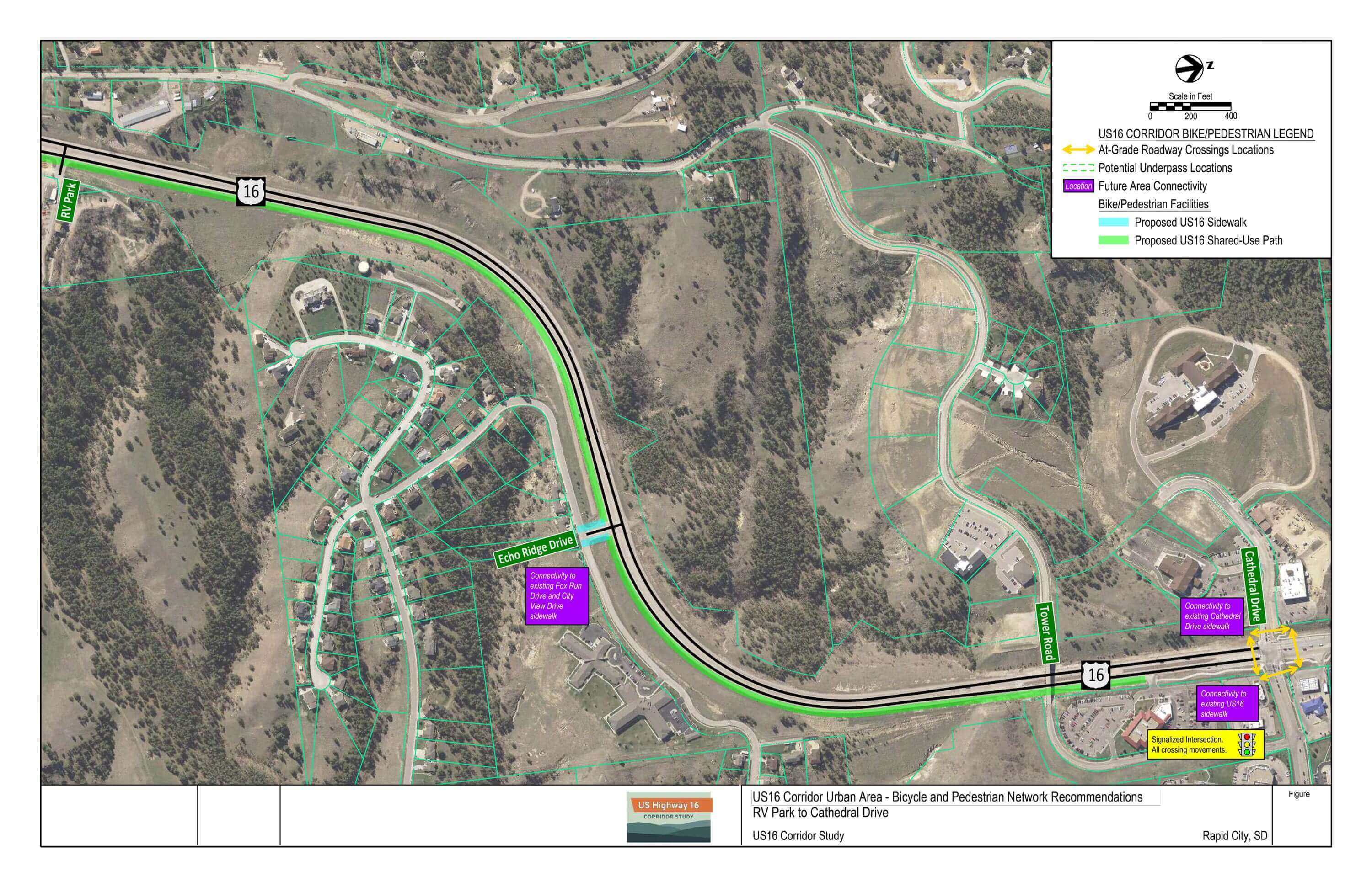
The US16 Urban Area Pedestrian and Bicycle recommendations present a long-range plan for facilities along the urban area US16 corridor. This plan serves as an overarching guide for incorporating shared-use path and sidewalk facilities in future projects and promoting a continuous and connected network.
Key Features:
- Continuous shared-use path on east side of US16 corridor
- Continuous sidewalk on west side of US16 corridor south of Tower Road
- Located west of US16 service road to minimize pedestrian/vehicle conflicts
Potential connections to existing and future facilities are noted in the figure. Coordination with future development is encouraged to identify other beneficial ‘mid-segment’ connections.
Potential Bicycle/Pedestrian Underpass Locations
Grade-separated (underpass) bicycle/pedestrian crossings of high-speed, high-volume corridors is a notable benefit to bicycle/pedestrian safety, corridor/intersection traffic operations, and area multimodal connectivity. Potential underpass locations have been identified for further consideration within the US16 urban area based on:
- Locations
- Close proximity to existing/planned major intersection to encourage use of underpass instead of at-grade intersection
- Along potential high-use routes
- Distributed across the corridor to minimize out-of-the-way travel
- Natural low spots where existing terrain is conducive to constructing a bicycle/pedestrian underpass
Click the images above to enlarge.
Urban Area Local Roadway Network
Planning Framework – Download PDF
Plan Overview
Construction of local network roadways along the corridor are driven by development, that as areas are developed, the roadway network will be constructed with tie points to existing infrastructure. To date, City of Rapid City, RCAMPO, and SDDOT area planning has provided the framework for the future local roadway network through the Rapid City Major Streets Plan.
The US16 Urban Area Local Network figure builds upon the Rapid City Major Streets Plan to incorporate the Consultant Recommendation of an SPI at US16/US16B/Catron Boulevard. This figure represents a long-range access and local network connectivity plan for the US16 urban area surrounding the US16/US16B/Catron Boulevard intersection.
ITS Plan
Corridor Layout Plan – Download PDF
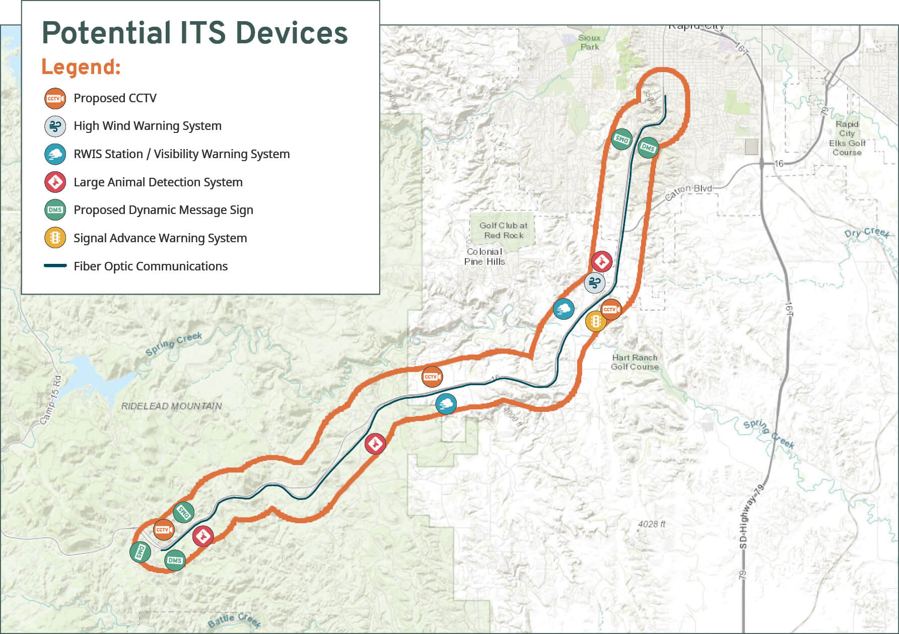
Plan Overview
The ITS recommendations figure presents potential ITS technologies and deployment locations for consideration as part of improvements to the US16 corridor. These recommendations can be used as a guide to implement technologies as part of future corridor projects and/or SDDOT statewide ITS programs.
Click the image above to enlarge.
Long-Range Interchange Concepts
Concepts Overview
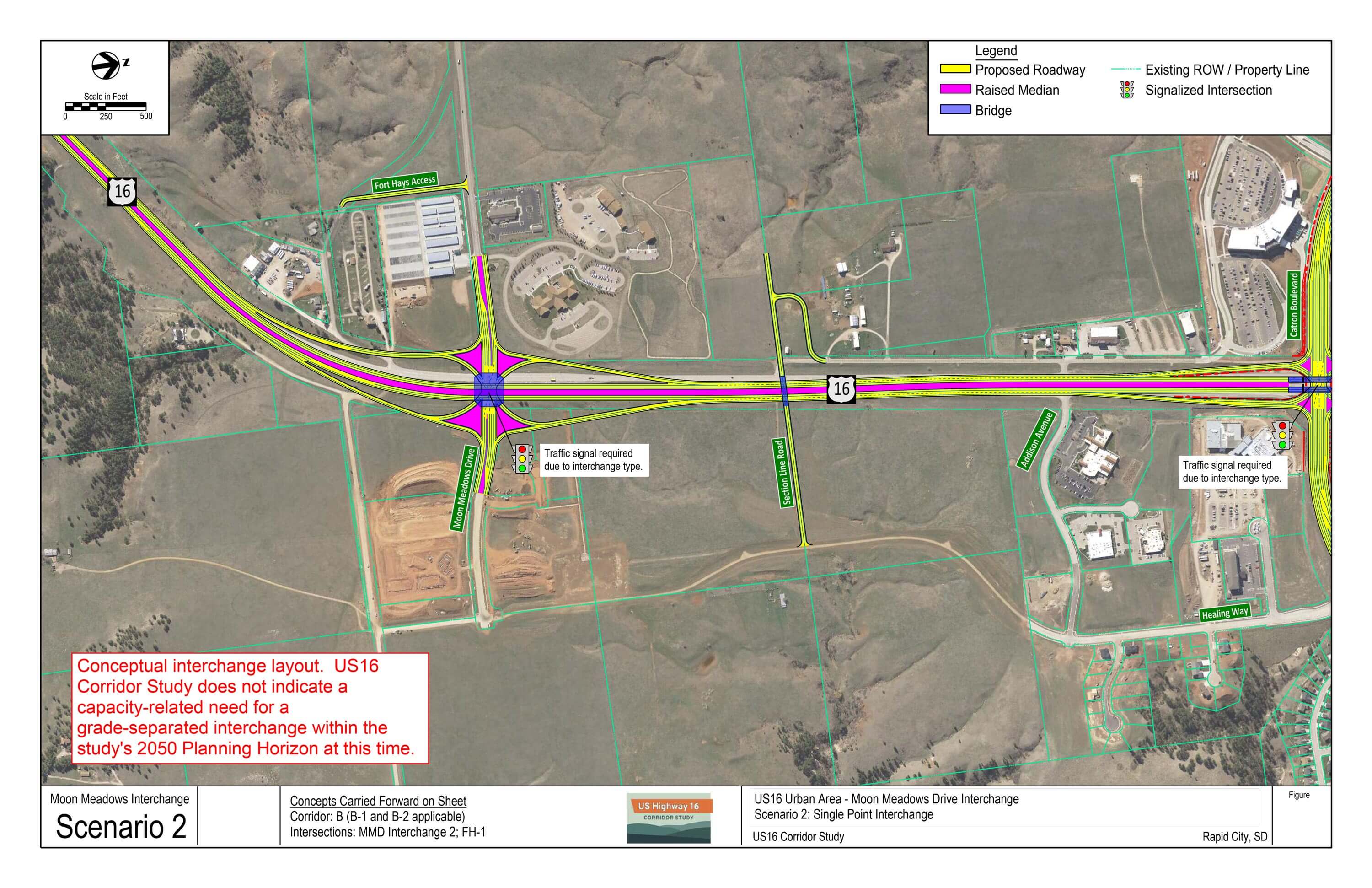
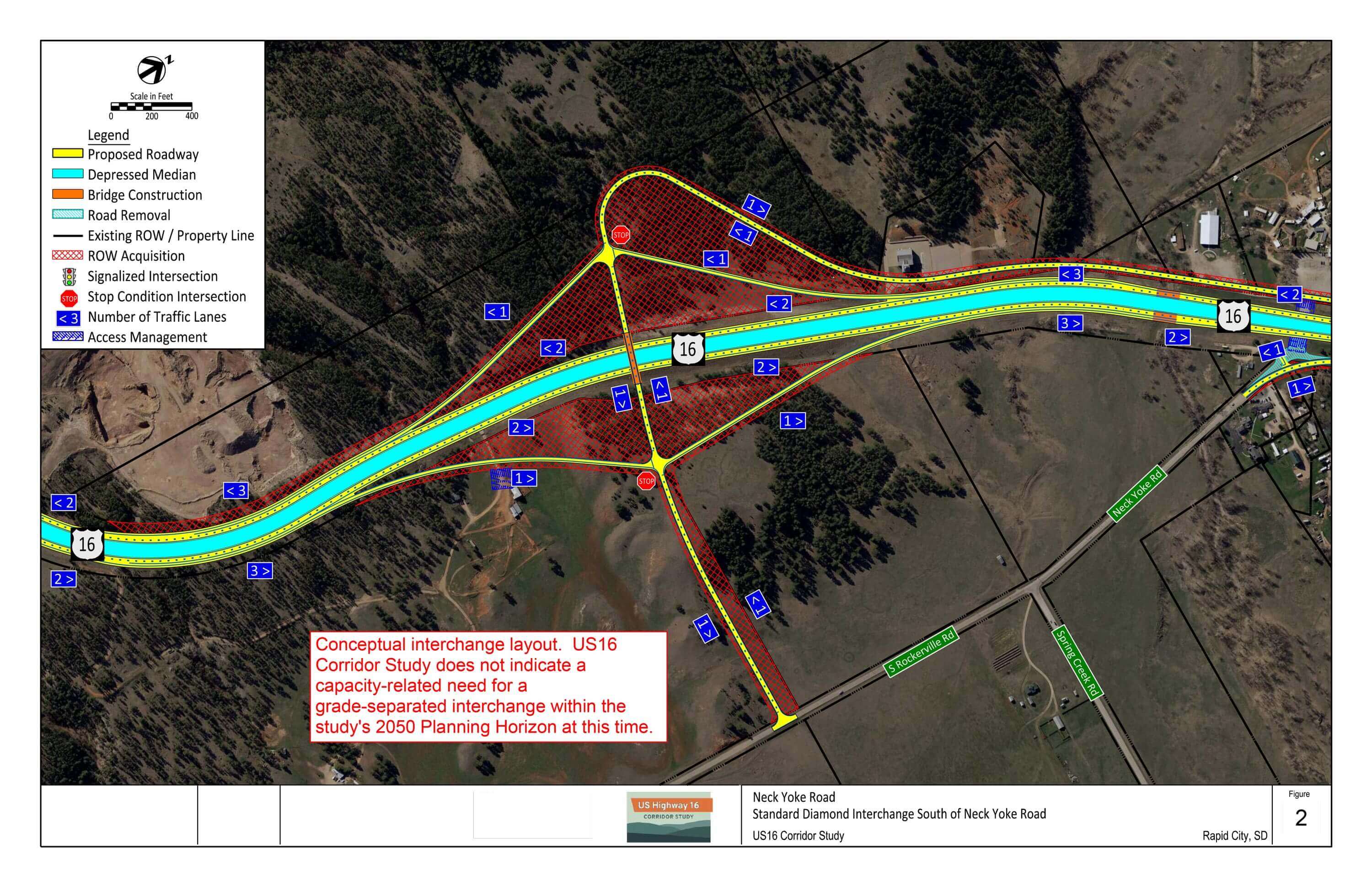
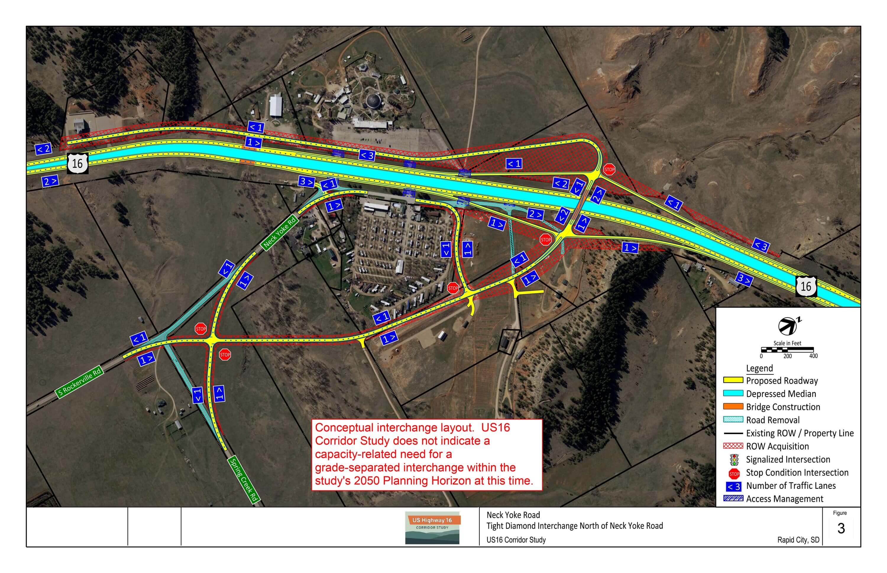
As part of the US16 Corridor Study, long-range interchange concepts were developed at US16/Moon Meadows Drive and US16/Neck Yoke Road areas to assess feasibility of illustrative interchange footprints in those locations. These concepts were not analyzed beyond developing an illustrative footprint.
Traffic operations analysis conducted at part of the corridor study does not identify any capacity-related need for grade-separated interchanges at either location within the study’s 2050 Planning Horizon. However, as volumes continue to grow along the US16 corridor and Rapid City development continues southward, there may be a time when it is desirable to separate east/west traffic conflicts from US16.
Conceptual interchange locations correlate to proposed arterial roadways identified in the City of Rapid City Major Street Plan.
- Moon Meadows Drive: proposed east/west Principal Arterial extension east to SD79
- Spring Creek Road: proposed Principal Arterial extension across US16 to the northwest
- Spring Creek Road currently connects to SD79
Interchange Concepts – Download PDF
US16/Moon Meadows Drive Interchange Concepts
Both scenarios reflect a SPI at US16/US16B/Catron Boulevard intersection and overpass at Section Line Road intersection.
Scenario 1: Diamond Interchange

Scenario 2: Single Point Interchange
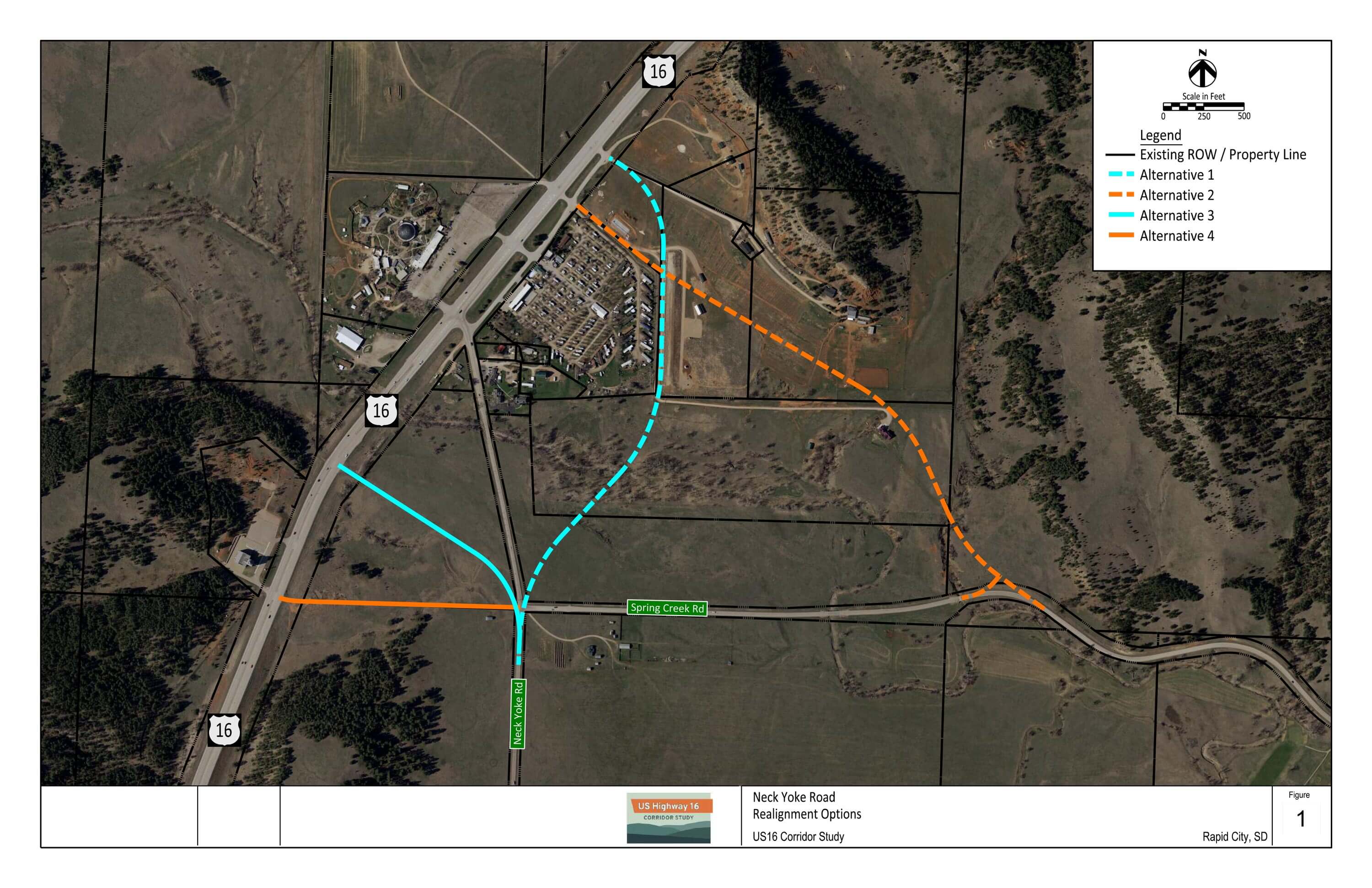
US16/Neck Yoke Road Area Interchange and Local Network Concepts
Local network alignment concepts
Standard diamond interchange south of Neck Yoke Road
Tight diamond interchange north of Neck Yoke Road
Click the image above to enlarge.
Schedule and Definitions
Additional Project Information
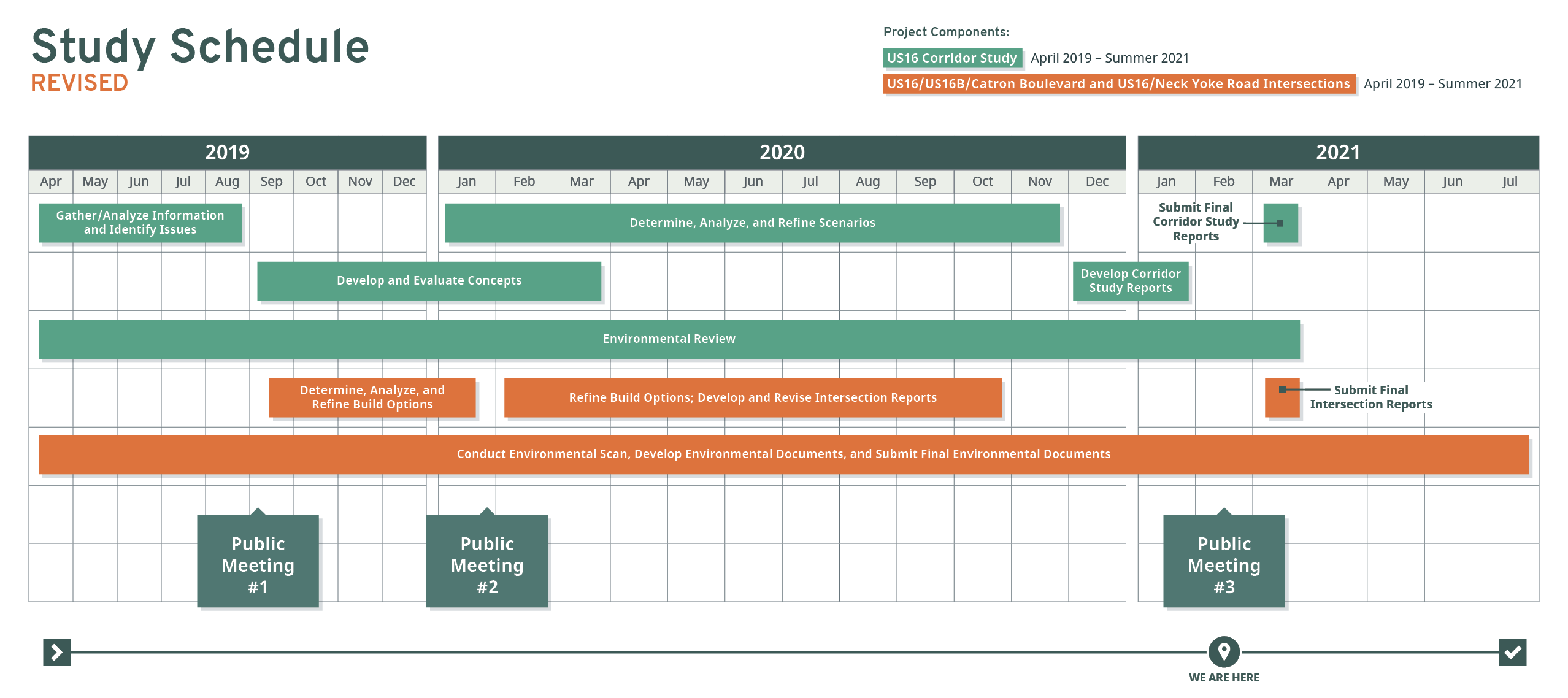
Project Schedule
Review the high-level schedule below to see how the project has progressed. Final reports are tentatively scheduled for delivery in late 2021.
Click the image above to enlarge.
Level of Service Definitions
Level of service (LOS) is a quantitative stratification of performance measures representing quality of service, or how well a transportation facility operates from a traveler’s perspective.
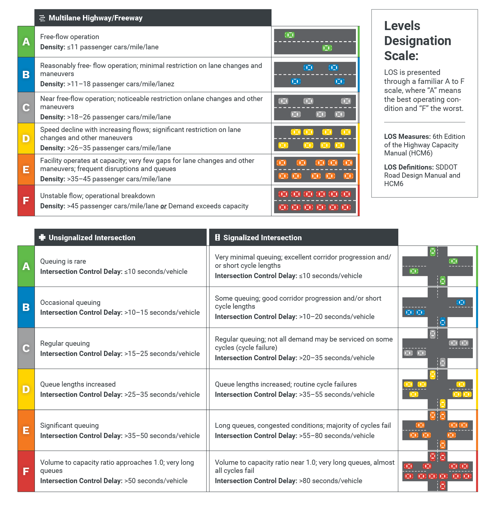
Click the image above to enlarge.
Stay Connected
Thank you for your participation!
Tell Us What You Think
Input collected will aid in the development of study recommendations and general timeline for implementation.
- Questions and comments will be accepted February 28, 2021 and may be submitted through the study website or by reaching out to one of the project representatives via email or phone.
Share This Information
Please pass along the link to this virtual open house to family, friends and coworkers who use this stretch of US 16 and these intersections.
Contact Information
To submit a general comment or question for the project team, click on the comment button in the top right corner of your screen.
Questions for the project team?
Jon Wiegand, P.E., PTOE, Consultant Project Manager (HDR)
jonathan.wiegand@hdrinc.com | 605-782-8105
Steve Gramm, P.E., SDDOT Project Manager
steve.gramm@state.sd.us | 605-773-6641